|
Policy Committee Komiti Kaupapa Here
PP20-3 Tuesday, 28 July 2020 Council Chambers Barkes Corner, Tauranga 9:30am
|

|
Policy Committee Komiti Kaupapa Here
PP20-3 Tuesday, 28 July 2020 Council Chambers Barkes Corner, Tauranga 9:30am
|
|
28 July 2020 |
Policy Committee
Membership
|
Chairperson |
Mayor Garry Webber |
|
Deputy Chairperson |
Cr Monique Lints |
|
Members |
Cr Grant Dally Cr Mark Dean Cr James Denyer Cr Murray Grainger Cr Anne Henry Cr Christina Humphreys Cr Kevin Marsh Cr Margaret Murray-Benge Cr John Scrimgeour Cr Don Thwaites |
|
Quorum |
6 |
|
Frequency |
Six weekly |
Role:
· To develop and review strategies, policies, plans and bylaws to advance the strategic direction of Council and its communities.
· To ensure an integrated approach to land development (including land for housing), land use and transportation to enable, support and shape sustainable, vibrant and safe communities.
· To ensure there is sufficient and appropriate housing supply and choice in existing and new urban areas to meet current and future needs.
Scope:
· Development and review of bylaws in accordance with legislation including determination of the nature and extent of community engagement approaches to be employed.
· Development, review and approval of strategies and plans in accordance with legislation including determination of the nature and extent of community engagement approaches to be employed.
· Subject to compliance with legislation and the Long Term Plan, to resolve all matters of strategic policy outside of the Long Term Plan process which does not require, under the Local Government Act 2002, a resolution of Council.
· Development of District Plan changes up to the point of public notification under the Resource Management Act 1991.
· Development of the Future Development Strategy and urban settlement plan.
· Consider and approve changes to service delivery arrangements arising from service delivery reviews required under the Local Government Act 2002 (provided that where a service delivery proposal requires an amendment to the Long Term Plan, it shall thereafter be progressed by the Annual Plan and Long Term Plan Committee).
· To report to Council on financial implications of policies and recommend any changes or variations to allocated budgets.
· Listen to and receive the presentation of views by people and engage in spoken interaction with people pursuant to section 83(1)(d) of the Local Government Act 2002 in relation to any processes Council undertakes to consult on under the special consultative procedure as required by the Local Government Act 2002 or any other Act.
· Oversee the development of strategies relating to sub-regional parks and sub-regional community facilities for the enhancement of the social and cultural wellbeing of the Western Bay of Plenty District communities, for recommendation to Tauranga City Council and Western Bay of Plenty District Council.
· Develop the draft Statement of Intent for any Council Council-Controlled organisation (CCO) and review, assess and make recommendations to Council on any modifications to CCO or other entities’ accountability documents (i.e. Letter of Expectation, Statement of Intent) or governance arrangements.
· Approve Council submissions to central government, councils and other organisations, including submissions on proposed plan changes or policy statements.
· Receive and make decisions and recommendations to Council and its Committees, as appropriate, on reports, recommendations and minutes of the following:
- SmartGrowth Leadership Group
- Regional Land Transport Committee
- Any other Joint Committee, Forum or Working Group, as directed by Council.
· Receive and make decisions on, as appropriate, any matters of a policy or planning nature from the following:
- Waihi Beach, Katikati, Ōmokoroa, Te Puke and Maketu Community Boards,
- Maketu-Te Puke Ward Forum
- Kaimai Community Ward Forum
- Katikati- Waihi Beach Ward Forum
Power to Act:
· To make all decisions necessary to fulfil the role and scope of the Committee subject to the limitations imposed.
Power to Recommend:
· To Council and/or any Committee as it deems appropriate.
Power to sub-delegate:
· The Committee may delegate any of its functions, duties or powers to a subcommittee, working group or other subordinate decision-making body subject to the restrictions within its delegations and provided that any such sub-delegation includes a statement of purpose and specification of task.
|
Policy Committee Meeting Agenda |
28 July 2020 |
Notice is hereby given that a Policy Committee Meeting
will be held in the Council Chambers,
Barkes Corner, Tauranga on:
Tuesday, 28 July 2020 at 9:30am
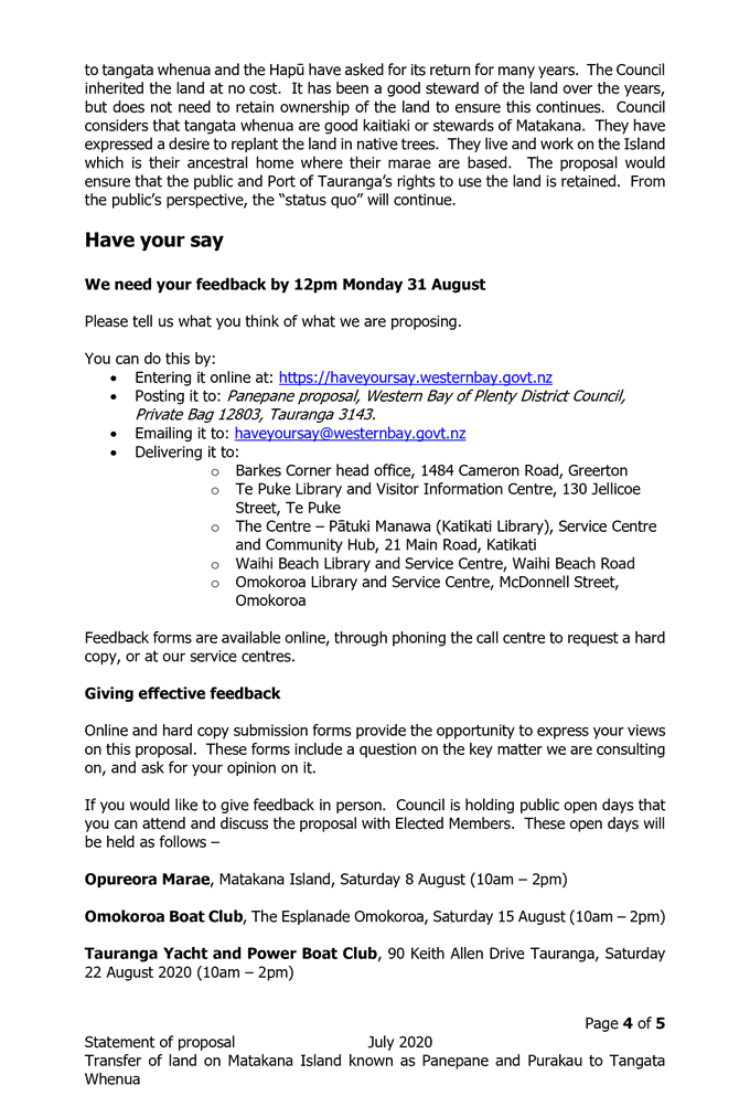
9.1 Panepane - Issues and Options
9.2 Adoption of the draft Speed Limits Bylaw 2020 for consultation
9.3 Island View Reserve - Playground And Bbq Draft Concept Plan
1 Present
Members are reminded of the need to be vigilant and to stand aside from decision making when a conflict arises between their role as an elected representative and any private or other external interest that they may have.
A period of up to 30 minutes is set aside for a public forum. Members of the public may attend to address the Board for up to five minutes on items that fall within the delegations of the Board provided the matters are not subject to legal proceedings, or to a process providing for the hearing of submissions. Speakers may be questioned through the Chairperson by members, but questions must be confined to obtaining information or clarification on matters raised by the speaker. The Chairperson has discretion in regard to time extensions.
Such presentations do not form part of the formal business of the meeting, a brief record will be kept of matters raised during any public forum section of the meeting with matters for action to be referred through the customer contact centre request system, while those requiring further investigation will be referred to the Chief Executive.
|
28 July 2020 |
9.1 Panepane - Issues and Options
File Number: A3688799
Author: Chris Nepia, Māori Relationships and Engagement Advisor
Authoriser: Rachael Davie, Group Manager Policy Planning And Regulatory Services
Executive Summary
1. Council has been approached to return the land at Panepane and Part Purakau also known as Lot 3 DP450007 PT Allot 13 SO 22298 BLKVI Tauranga SD (Panepane) to the hapū of Matakana Island.
2. A presentation on the matter was made by representatives of the five hapū of Matakana Island to a meeting of the Tauranga Moana and Te Arawa ki Takutai Partnership Forum on 10 February 2020. At that meeting it was resolved that the Tauranga Moana and Te Arawa ki Takutai Partnership Forum recommend to the Policy Committee that it commence the process to effect the transfer of Panepane/Purakau as broadly outlined in the resolution of Council dated 17 December 2015.
3. This report forms part of the decision making process of Council in deciding whether and if so how to give effect to that recommendation.
|
1. That the Māori Relationships and Engagement Advisor’s Report dated 28 July 2020 and titled “Panepane – Issues and Options” be received and the options identified in that Report be assessed in terms of their advantages and disadvantages before making a decision whether to adopt the Statement of Proposal prepared for recommended Option A; AND 2. That the report relates to an issue that is considered to be of high significance in terms of Council’s Significance and Engagement Policy; AND 3. That the Statement of Proposal prepared for Option A attached to this report is adopted for public consultation pursuant to sections 83 and 87 of the Local Government Act 2002 during the period from 29 July 2020 to 12:00pm, 31 August 2020; OR 4. That Option B1 of this report is preferred, which will require development of a separate statement of proposal which may then be adopted for public consultation pursuant to sections 83 and 87 of the Local Government Act 2002; OR 5. That Option B2 of this report is preferred, which will require development of a separate statement of proposal which may then be adopted for public consultation pursuant to sections 83 and 87 of the Local Government Act 2002; OR 6. That Option C of this report (the status quo) is preferred in which case no further steps are required. |
Background
Panepane land
4. Panepane consists of approximately 178 hectares of land at Matakana Island spread across two legal titles known as Panepane and Purakau. It is currently owned by Western Bay of Plenty District Council and is used for forestry purposes. The Port of Tauranga has navigational aids located on the land. The five hapū of Matakana Island have long desired for ownership of Panepane to be returned to them, which they reinforced at a presentation to a meeting of the Tauranga Moana and Te Arawa ki Takutai Partnership Forum on 10 February 2020.
Panepane history
5. Prior to the mid 1800s, Panepane was held by the hapū of Matakana Island in accordance with tikanga Māori (Māori custom). Māori custom had no concept of land ownership that could be equated to the western concept of legal title, instead land held by iwi or hapū was used and cared for to the exclusion of others. This created a relationship of kaitiakitanga (stewardship) that iwi and hapū had with land which encompassed rights and privileges but also obligations. Panepane is significant to the hapū of Matakana Island because of this history. Following the battles of Gate Pa and Te Ranga in 1864 the government of the time proclaimed Tauranga a confiscated district, Panepane was included in this proclamation which in effect meant that the hapū of Matakana Island no longer held Panepane in accordance with Māori custom even though they continue to uphold their kaitiakitanga obligations to this day.
6. Legislation that was passed around the same time that the area of Tauranga was proclaimed a confiscation district, required legal title of land there to be determined. This lead to the surveying and vesting of large parcels of land in Tauranga, including Panepane, to individuals. Title to Panepane was vested in the ownership of five Māori owners in 1877 and in 1912 ownership of Purakau was vested in twelve Māori owners. In effect, confiscation brought about the end to the customary way that the hapū of Matakana held Panepane which was further compounded by granting legal title to a handful of Māori owners.
Public Works Act
7. Following all of the historical land dealings involving Panepane, the land was compulsorily acquired in 1923 by the Tauranga Harbour Board for harbour purposes under the Public Works Act 1908. The land was acquired to provide navigational aids for ships entering the harbour and to prevent erosion at Matakana Island. Compensation of £1 per acre was paid for Panepane and 10 shillings per acre was paid for Purakau. The Public Works Act acquisitions of the time have been criticised by the Waitangi Tribunal in its Tauranga Moana report which observed that –
For successive New Zealand governments, the transformative power of public works was an article of faith. They energetically expanded their powers of compulsory acquisition across an increasingly diverse range of works, believing that central government should be the planner and undertaker of major infrastructure works. The same powers were extended to local government in order to provide local amenities. This changed after 1981. However, by this time substantial amounts of land had been taken from Tauranga Māori for public works, and some of their most iconic sites, urupā, marae, and food-gathering places were damaged or otherwise adversely affected. Often the acquisitions occurred without the consent of the owners, and sometimes even without their knowledge.
8. The Tauranga Harbour Board continued to own Panepane until local government reform in 1989 saw harbour boards disestablished. As a result, ownership of Panepane was vested in the Western Bay of Plenty District Council (Council).
9. Council inherited the land at no cost and has been a good steward of the land over the years. It considers that Tangata Whenua will be good kaitiaki (guardians/stewards) of the land with the hapū representatives expressing a desire to replant the land in native trees. They live and work on Matakana Island, their ancestral home where their Marae are based.
10. Council acknowledges that Panepane is historically significant to the hapū of Matakana Island and since 2015 has progressed the development of options for the return of the land to the hapū of Matakana Island.
2015 Council resolution
11. In June 2015 a discussion paper was presented to a workshop of Council’s Policy and Strategy Committee with some options for Council to consider around the return of Panepane to the hapū of Matakana Island. Subsequent to this workshop, Council considered the issue again in December 2015 and resolved as follows –
1. That the Group Manager Policy, Planning & Regulatory Services’ report dated 4 December 2015 and titled Panepane/Purakau be received.
2. That the report relates to an issue, being the transfer of land (Panepane/Purakau), that is considered to be of medium to high significance in terms of Council’s Significance and Engagement Policy.
3. That the transfer of Panepane/Purakau involves a process of engagement and decision making and at this stage Council is not making a decision to transfer the land.
4. That Council initiate work towards promoting a Local Act of Parliament that would provide for the transfer of ownership of Panepane/Purakau to an entity representative of relevant tangata whenua subject to certain principles including the ability of Council to administer the land as a local purpose reserve, in partnership with tangata whenua, and retention of access to harbour navigational aids and certain identified parts of the land.
5. That the resolution only be transferred into the open section of the meeting and that the Matakana Island Hapū be advised of the decision forthwith.
6. That following the Development of a Comprehensive Community Engagement Plan this decision be communicated to the wider public.
Post 2015 discussions
12. In early 2016 the parties (Council staff and representatives of each of the five hapū of Matakana Island) came together as the Panepane Project Group to begin the work of progressing Council’s December 2015 resolution. The project group have met a number of times and as a result of those meetings some changes have been made to the proposed approach of returning Panepane.
13. Option A below provides detail on what is being recommended by staff with the support of the Hapū as a result of the work of the Panepane Project Group.
Engagement, Consultation and Communication
|
Interested/Affected Parties |
Completed/Planned
|
|
|
Tangata Whenua |
This issue has been presented to the Tauranga Moana and Te Arawa ki Takutai Partnership Forum where support from iwi and hapū members was provided unanimously. Work on this issue has involved the hapū of Matakana Island as members of the Panepane Project Group and all matters of importance to Tangata Whenua have been discussed within the meetings of that group and more widely within the hapū at various hui in accordance with their tikanga. While Council is aware that some differences of views have been expressed, including from descendants of the individual Māori owners of Panepane prior to the land being taken under the Public Works Act (who are also members of the Hapū), Council understands that those differences are being resolved between the Hapū directly. Council staff have also met directly with the descendant group to understand their perspective on the transfer of Panepane to the Hapū. Staff understand that they are supportive of the general kaupapa of returning the whenua back to Māori ownership and would prefer to work with the Hapū rather than assert a private claim to the land. Any outstanding issues are expected to be resolved through the public consultation process and further engagement with stakeholders. |
Completed |
|
General Public |
If Council endorses the recommendation in this report it will be a decision considered to be of high significance which means Council will be required to use the special consultative procedure under the Local Government Act. |
Planned |
Issues and Options Assessment
14. The following reasonably practicable options have been identified in order to achieve the objective of transferring ownership of Panepane to the Hapū. While the status quo does not achieve this objective, it is included as the obvious counterfactual to assist in testing the options. The advantages and disadvantages of the options are assessed below. Because the transfer of Panepane involves a significant decision in relation to land of undisputed significance to tangata whenua, the relationship of Māori and their culture and traditions with their ancestral land has necessarily been taken into account as required under s77 of the Local Government Act 2002.
|
Option A Proposal developed by the Panepane Project Group
Council would transfer ownership of approximately 167 hectares of land at Panepane as shown in the map in Attachment One, to a Trust that has been established to represent the hapū of Matakana Island being Ngai Tuwhiwhia, Te Ngare, Ngai Tamawhariua, Te Whānau a Tauwhao and Ngati Tauaiti (the hapū trust). The transfer of the land would be conditional on the following –
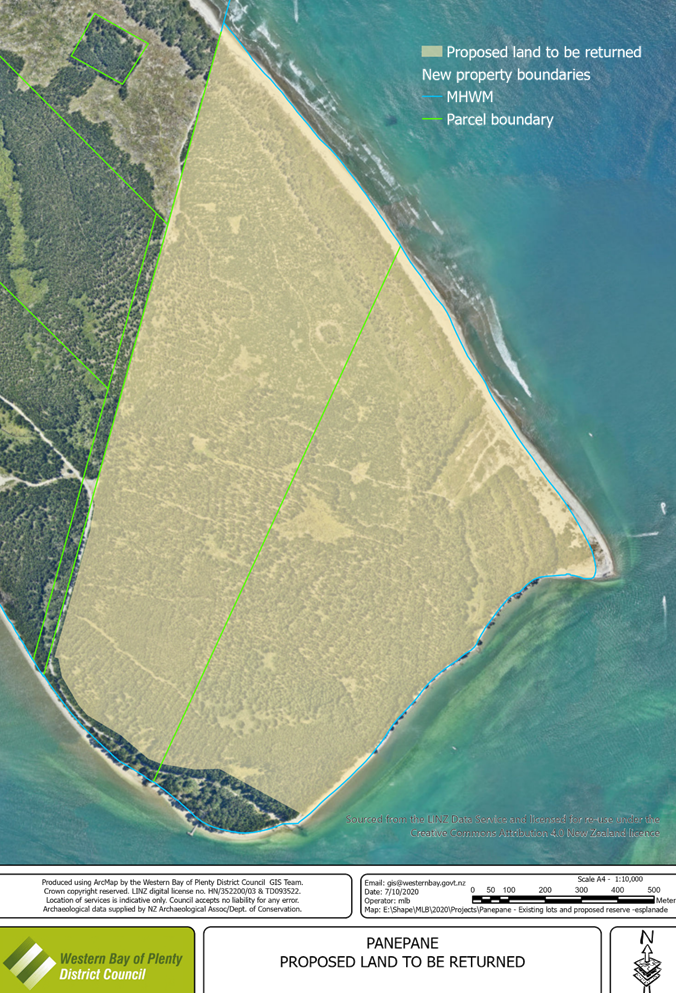
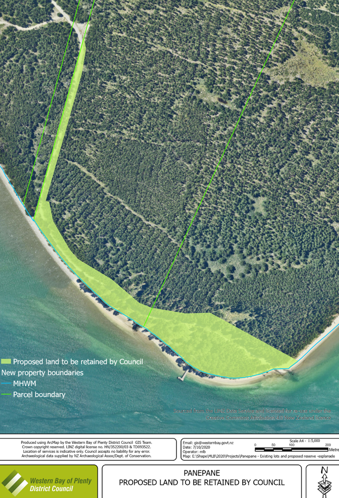
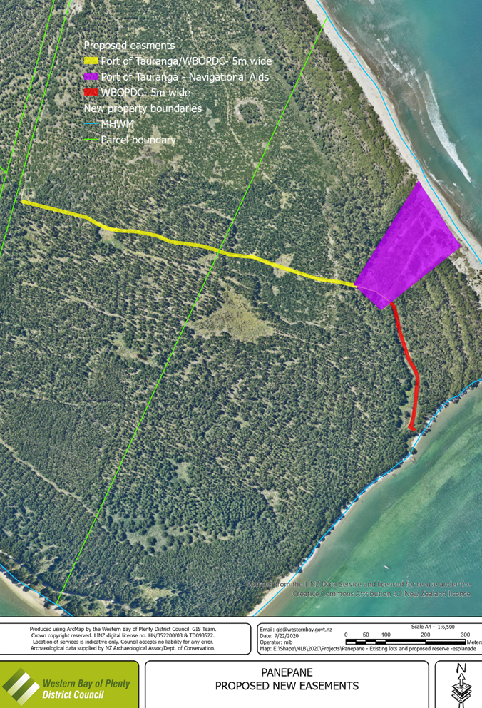
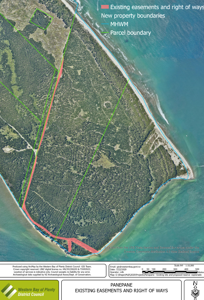
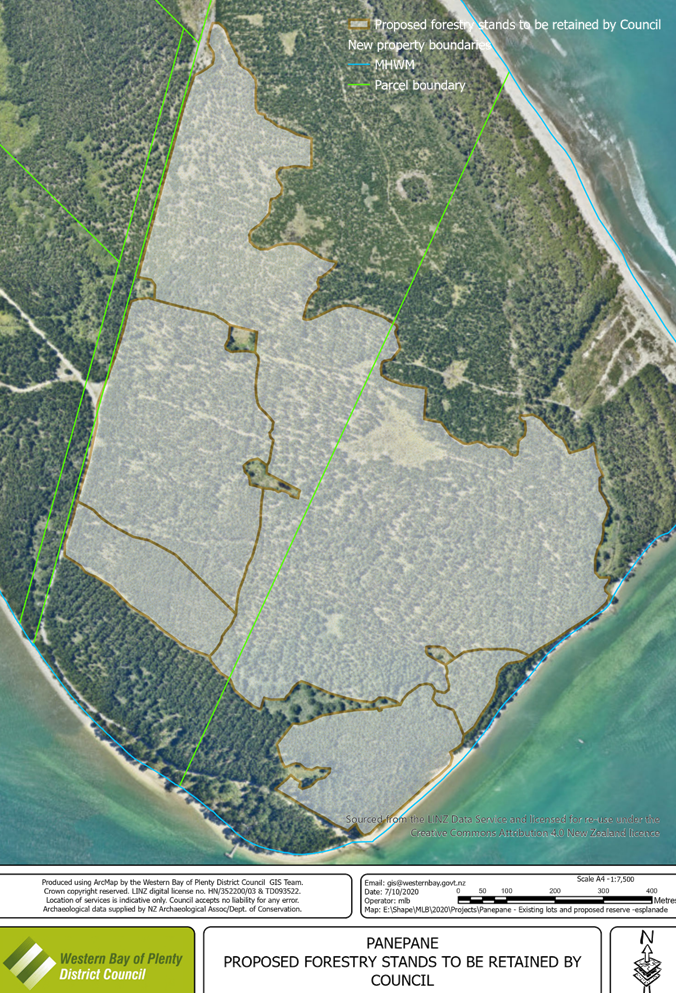
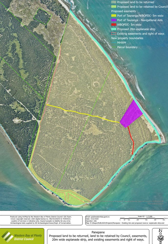
- That Council would retain ownership of 7.8099 hectares of land at Panepane as shown in the map in Attachment Two, with this land to be administered as a public (local purpose) reserve under the Reserves Act; - That a 20 metre wide public esplanade strip (the esplanade strip) would be created around the coastal boundary of Panepane as outlined in Attachment Three. The esplanade strip is measured from the line of mean high water springs and would always remain 20 metres wide regardless of natural processes altering the physical landform such as erosion or accretion. The land underlying the esplanade strip would be owned by the hapū trust but the public would have access rights over it; - That an easement be established in favour of the Port of Tauranga and Council to provide for the continued access to, location and operation of the harbour navigational aids as outlined in the map at Attachment Four. - That all other existing easements over Panepane as outlined in the map at Attachment Five would remain in place; - That Council would retain the pine trees on the land at Panepane which are ready for harvest. These trees cover approximately 82.1 hectares of land at Panepane as shown in the map in Attachment Six and once harvested would be replanted by Council. The balance of trees on the land will transfer to the hapū trust. - That Council retains the Emissions Trading Scheme credits that were allocated in relation to Council’s land holdings on Matakana Island and the Hapū would be responsible for ETS liabilities once the land is transferred and the trees from Council’s harvest replanted.
|
|
|
Advantages
- Significantly strengthens and improves the relationship between Council and the hapū of Matakana Island as the proposal addresses their long held desire to have a significant piece of land returned to them and mitigate the impacts of confiscation and land acquisition under the Public Works Act; - Would enable tangata whenua to collectively own the land and exercise collective responsibility over it (fulfilling concepts of kaitiakitanga, rangatiratanga and manaakitanga). - Improves Council’s relationships with Tangata Whenua across the Western Bay of Plenty district who support the proposal; - Public access to the wharf and barge landing and the coastline of Panepane will continue to be permitted; - Allows for the ongoing use and maintenance of the navigational aids of the Port of Tauranga; - Council retains the income from harvesting a significant portion of the trees on the land at Panepane. |
Disadvantages
- Council no longer owns a significant strategic asset (apart from the wharf area); - If the descendants of the owners of Panepane from whom the land was acquired under the Public Works Act, do not agree with this approach, they are likely to feel aggrieved affecting Council’s relationship with them and may seek to have the land offered back to them under the Public Works Act.
|
|
Costs (including present and future costs, direct, indirect and contingent costs). |
- Legal costs to give effect to the transfer of land to the hapū of Matakana Island; - Ongoing costs associated with the joint management arrangements of the reserve area to be retained and the esplanade strip |
|
Option B 1 Return to descendants of original owners as approved by Māori Land Court
Council would transfer ownership of approximately 167 hectares of land at Panepane as shown in the map in Attachment One to the descendants of the individual owners who the land was taken from under the Public Works Act either at no cost or a cost to be determined by the Māori Land Court. If it adopts this option Council would seek direction from the Māori Land Court as to the most appropriate entity to own the land (which may represent those owners or the wider Hapū as proposed under Option A), and then transfer it to the entity approved by the Māori Land Court. Council would prepare the application to the Court on the basis of the following conditions, recognising that the Court would need to approve the conditions and could substitute its own different conditions –
- That Council would retain ownership of 7.8099 hectares of land at Panepane as shown in the map in Attachment Two, with this land to be administered as a public (local purpose) reserve under the Reserves Act; - That a 20 metre wide public esplanade strip (the esplanade strip) would be created around the coastal boundary of Panepane as outlined in Attachment Three. The esplanade strip is measured from the line of mean high water springs and would always remain 20 metres wide regardless of natural processes altering the physical land form such as erosion or accretion. The land underlying the esplanade strip would be owned by the entity approved by the Māori Land Court but the public would have access rights over it; - That an easement be established in favour of the Port of Tauranga and Council to provide for the continued access to, location and operation of the harbour navigational aids as outlined in the map at Attachment Four. This easement would be created prior to the transfer and would not form part of the application to the Court. - That all other existing easements over Panepane as outlined in the map at Attachment Five would remain in place. These existing easements would not be part of the proposal before the Court; - That Council would retain the pine trees on the land at Panepane which are ready for harvest. These trees cover approximately 82.1 hectares of land at Panepane as shown in the map in Attachment Six and once harvested will be replanted by Council. The balance of trees on the land would transfer to the entity approved by the Māori Land Court. - That Council retains the Emissions Trading Scheme credits that were allocated in relation to Council’s land holdings on Matakana Island and the new owners would be responsible for ETS liabilities once the land is transferred and the trees from Council’s harvest replanted. |
|
|
Advantages
- Provides the descendants of the former individual owners of Panepane with the opportunity to have the land returned to them on similar conditions to that proposed under Option A involving return to the Hapu; - Public access to the coastline of Panepane would continue to be permitted; - Allows for the ongoing use and maintenance of the navigational aids of the Port of Tauranga; - Council retains the income from harvesting a significant portion of the trees on the land at Panepane; - Depending on the consideration approved by the Māori Land Court, Council may have revenue from the sale of the land under those provisions. |
Disadvantages
- Broader hapū members of the five hapū of Matakana Island will not benefit from the return of this land. This is expected to impact negatively on Council’s relationship with those five hapū who Council have worked closely with on a number of issues in the past including having Matakana Island declared an Outstanding Natural Feature and Landscape by the Environment Court; - Council no longer owns a significant strategic asset (apart from the wharf area). |
|
Costs (including present and future costs, direct, indirect and contingent costs). |
- Legal costs in seeking a Māori Land Court determination on the correct ownership entity and subsequently effecting the transfer of ownership of the land to that entity. - Potential ongoing costs associated with any joint management arrangements associated with the reserve area to be retained and the esplanade strip |
|
Option B2 Offer land back to descendants of original owners If a valid claim to be offered the land back under the Public Works Act is established and pursued by the descendants of the original owners, under this option Council would offer the land back to those descendants at market value in accordance with the legislative requirements. All the land would need to be offered back, so this option does not involve the public reserve or the esplanade strip, unless agreed to with the new owners. |
|
|
Advantages - Provides the descendants of the former individual owners of Panepane with the opportunity to purchase the land back at market value - Council will receive revenue from the sale of the land |
Disadvantages - Broader hapū members of the five hapū of Matakana Island will not benefit from the return of this land. This is expected to impact negatively on Council’s relationship with those five hapū who Council have worked closely with on a number of issues in the past including having Matakana Island declared an Outstanding Natural Feature and Landscape by the Environment Court;
- Council no longer owns a significant strategic asset (apart from the wharf area). |
|
Costs (including present and future costs, direct, indirect and contingent costs). |
- Legal costs associated with offer back process and effecting the transfer of ownership of the land to the individual owners. |
|
Option C Status Quo Council will retain ownership of Panepane and will continue to use the land as it currently does. |
|
|
Advantages - Public access to the coastline of Panepane will continue to be permitted; - Allows for the ongoing use and maintenance of the navigational aids of the Port of Tauranga; - Council retains the income from harvesting the trees on the land at Panepane; - Council retains a significant strategic asset which can be used for future purposes provided they remain consistent with the “harbour works” purpose which the land is held for under the Public Works Act |
Disadvantages - Neither the five hapū of Matakana Island, nor the descendant owners, will have the land returned for their own use and benefit. This will likely impact negatively on Council’s relationship with both parties and with tangata whenua more generally who support the transfer back to tangata whenua. |
|
Costs (including present and future costs, direct, indirect and contingent costs). |
- No new costs arising from retaining the status quo rather than selecting another option. However, existing costs associated with managing Panepane will continue, as well as existing revenue streams. |
Statutory Compliance
15. The recommendations of this report are consistent with the Local Government Act 2002 requirements for consultation on significant matters
Funding/Budget Implications
|
Budget Funding Information |
Relevant Detail |
|
Legal costs
|
All associated legal costs can be met from the existing budgets related to the use and maintenance of the land at Panepane. |
1. Panepane
- Attachment 1 - Proposed land to be returned ⇩ ![]()
2. Panepane
- Attachment 2 - Proposed land to be retained by Council ⇩ ![]()
3. Panepane
- Attachment 3 - Proposed 20m wide esplanade strip ⇩ ![]()
4. Panepane
- Attachment 4 - Proposed new easements ⇩ ![]()
5. Panepane
- Attachment 5 - Existing easements and right of ways ⇩ ![]()
6. Panepane
- Attachment 6 - Proposed forestry stands to be retained ⇩ ![]()
7. Panepane
- All of proposal map ⇩ ![]()
8. Panepane
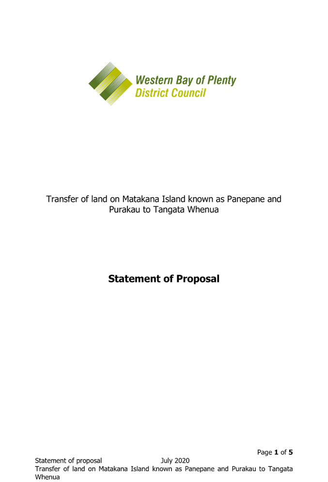
- Statement of proposal ⇩ ![]()
|
28 July 2020 |
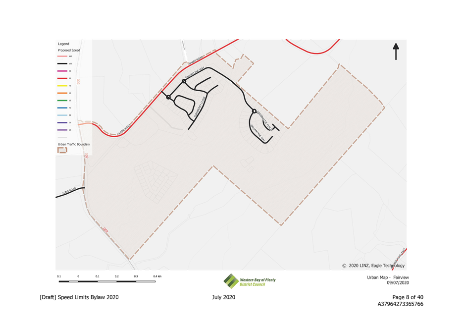
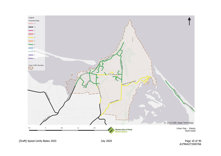
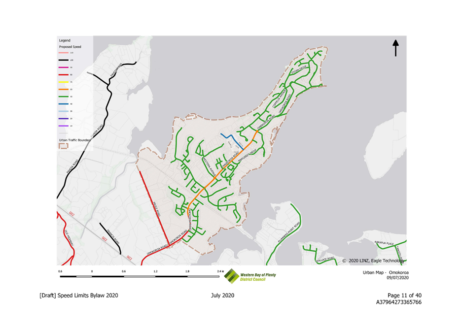
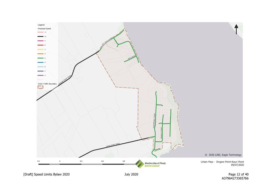
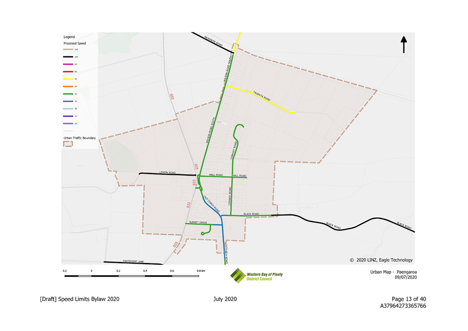
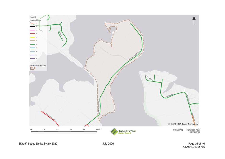
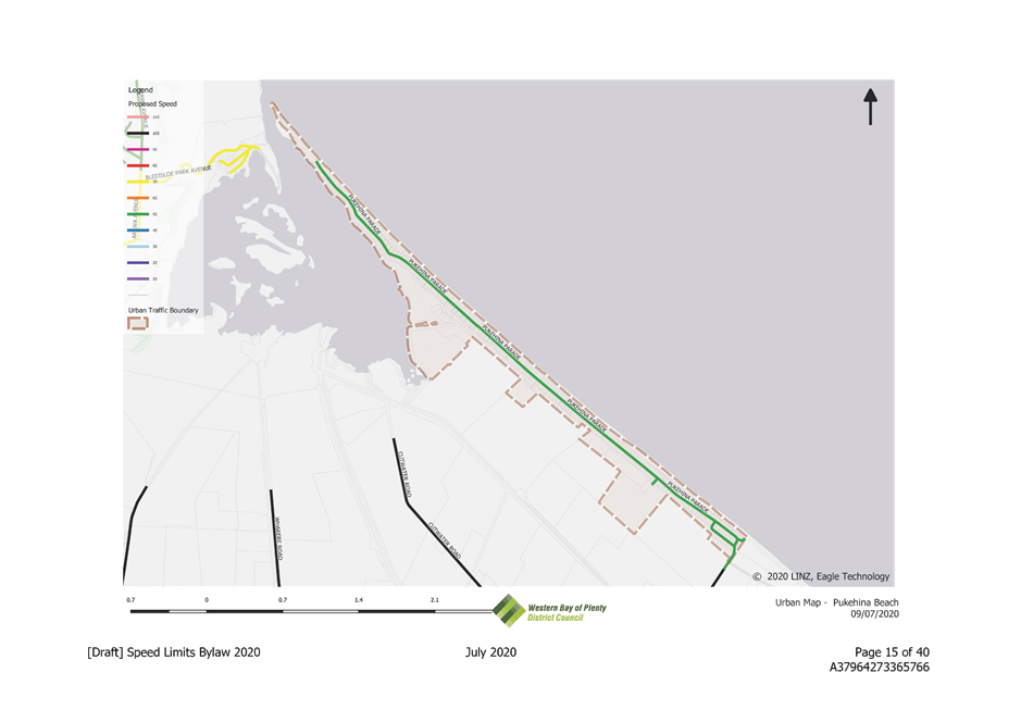
9.2 Adoption of the draft Speed Limits Bylaw 2020 for consultation
File Number: A3796028
Author: Emily Watton, Policy and Planning Manager
Authoriser: Rachael Davie, Group Manager Policy Planning And Regulatory Services
Executive Summary
1. This report presents the draft Speed Limits Bylaw 2020 and the associated draft documentation required to undertake consultation. The Committee is asked to consider adopting these in order to initiate a consultation process with the community.
|
1. That the Policy and Planning Manager’s report dated 28 July 2020 and titled ‘Adoption of the Draft Speed Limits Bylaw 2020 for consultation’ be received. 2. That the report relates to an issue that is considered to be of medium significance in terms of the Council’s Significance and Engagement Policy. 3. That the draft Speed Limits Bylaw 2020, the accompanying draft statement of proposal and feedback form as appended to this report are adopted for consultation, pursuant to section 22AD of the Land Transport Act 1998 and section 156 of the Local Government Act 2002, from 3 August 2020 to 4 September 2020. OR 4. That the draft Speed Limits Bylaw 2020 and associated documentation is not adopted for consultation. |
Background
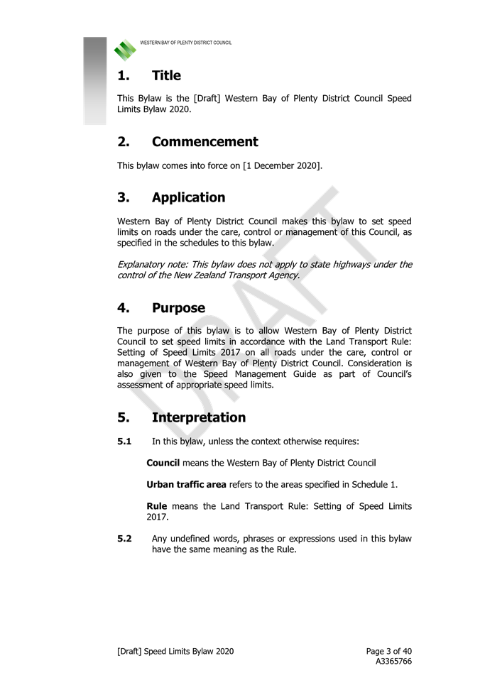
1. Section 22AB of the Land Transport Act 1998 empowers Council to set speed limits on roads under its care, control or management through a bylaw.
2. The last comprehensive review of the bylaw was in 2012, with some specific changes made to speed limits up until 2015. New legislation in 2015 directed Councils to follow a more rigorous process to set speed limits.
3. Council is not the Road Controlling Authority for state highways within our District – this responsibility sits with the New Zealand Transport Agency (NZTA). There are signage cost implications for Council if our local roads are not set to the same limit as the State Highway. Consequently, Council is seeking consistency with speed limit reviews initiated by the New Zealand Transport Agency on state highways through the Western Bay of Plenty District.
4. At the end of 2019, Government signalled it would be changing legislation to amend the way that Councils set speed limits. Councils will no longer use bylaws to set speed limits, but must develop a speed management plan that takes a wider view of the roading network, including safety upgrades and engineering solutions. At this time the legislative change is progressing, but there is no certainty as to when it will take effect
5. Since 2015, Council has received requests for speed limit changes from members of the community, Community Boards and through submissions to other consultation processes. These requests have all been subject to technical assessment by Council’s Roading team and contractor Westlink, to determine suitability of the request against the Land Transport Rule: Setting of Speed Limits 2003, the Speed Management Guide and other guidelines from NZTA.
6. Council considered this information through a workshop and directed staff to prepare a draft bylaw, to enable a partial review of speed limits to respond to community requests and address speed environments around our District’s schools. The changes to speed limits arising from this direction are set out in the following section of this report. It does not represent a whole of network speed limit review.
7. It is anticipated that a whole of network, District-wide speed limits review will be undertaken when the new legislation comes into effect. This will enable the development of a speed management plan, which is intended to have the broader focus on the roading network (beyond just speed limit changes).
8. It should be noted that the New Zealand Road Code recommends driving to the conditions irrespective of any set speed limit. Speed limits cannot be assumed to change driver behaviour without effective enforcement, the responsibility of which sits with the New Zealand Police.
Draft speed limit bylaw 2020 – proposed changes
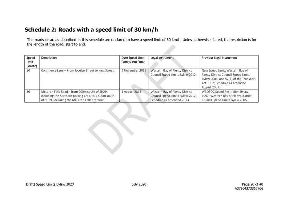
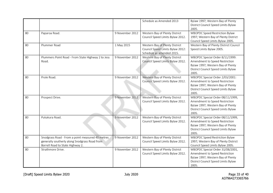
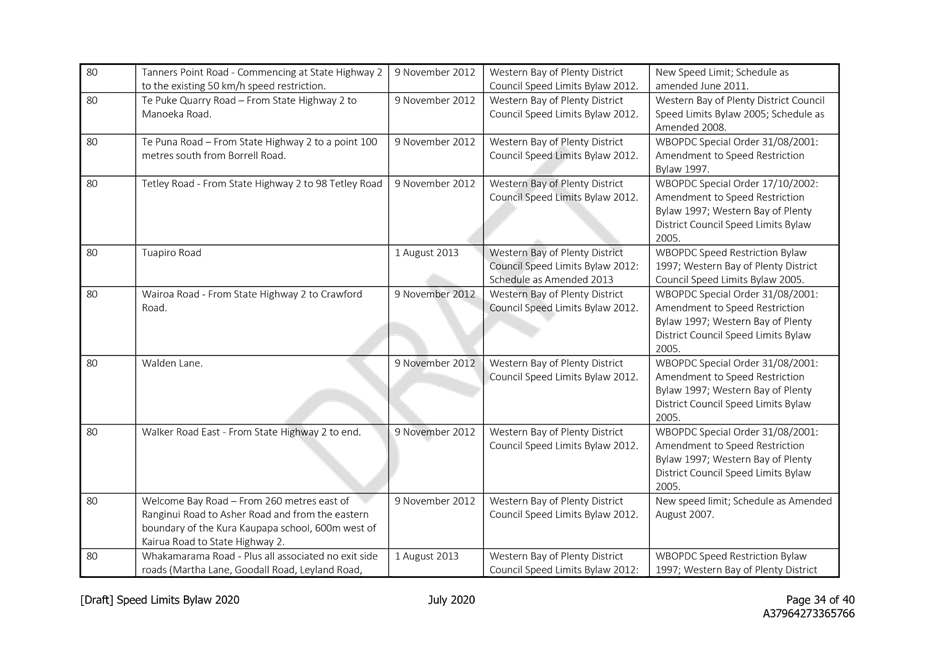
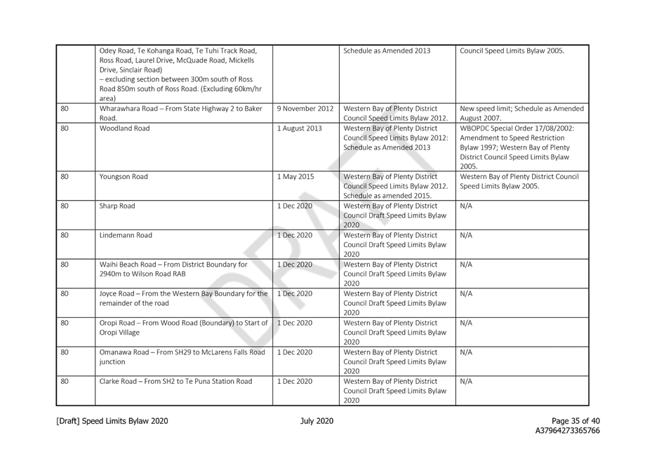
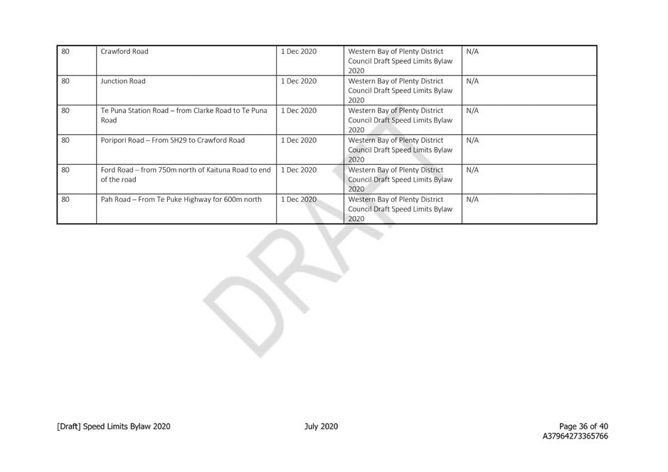
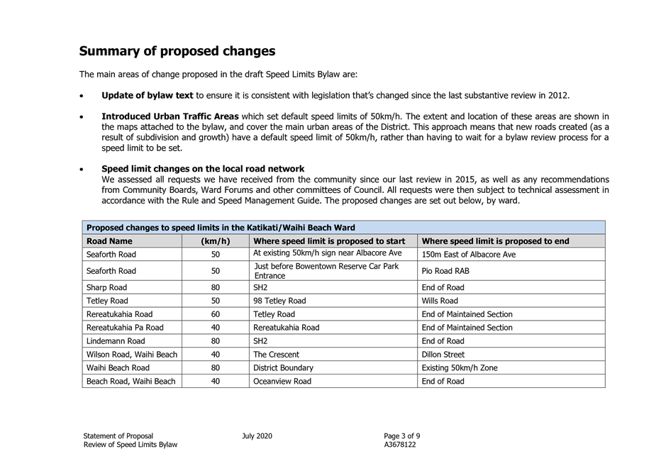
1. The key areas of proposed change:
· Update of bylaw text to ensure it is consistent with legislation that’s changed since the last substantive review in 2012.
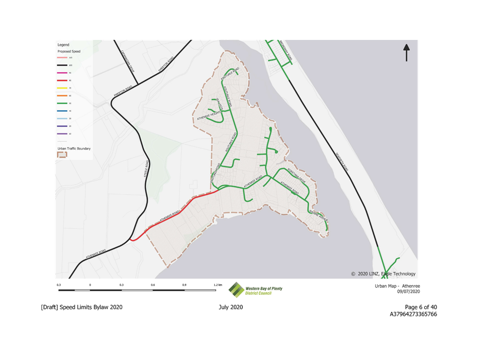
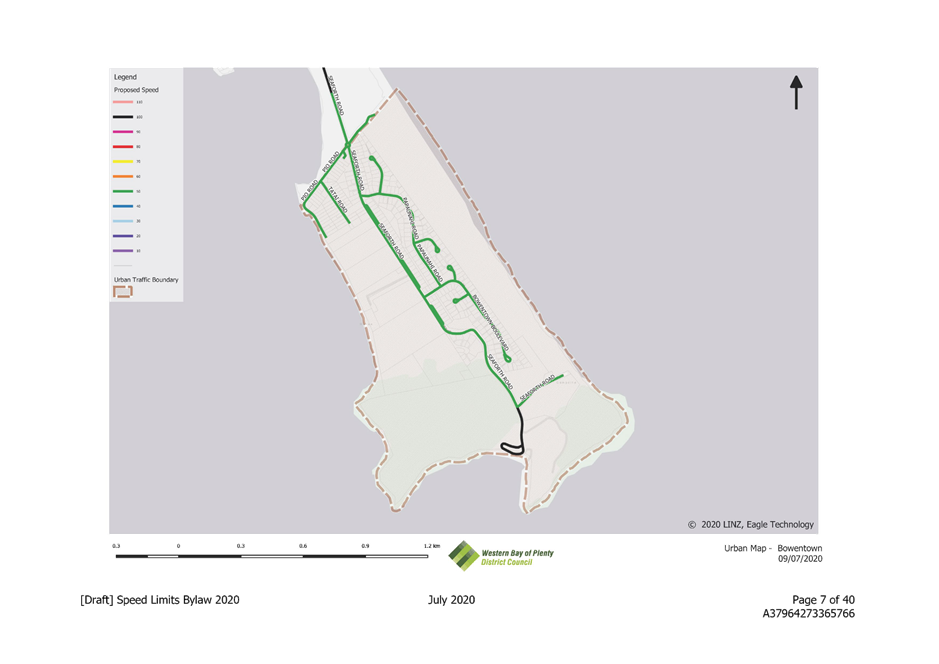
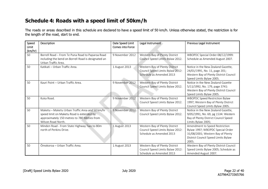
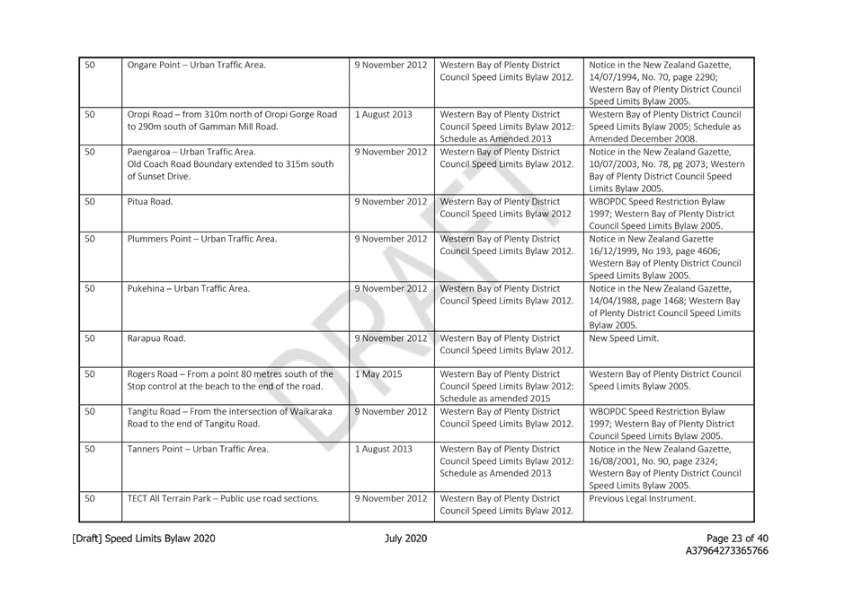
· Introduced Designated Urban Areas which set default speed limits of 50km/h. The extent and location of these areas are shown in the maps attached to the bylaw, and cover the main urban areas of the District. This approach means that new roads created (as a result of subdivision and growth) have a default speed limit of 50km/h, rather than having to wait for a bylaw review process for a speed limit to be set.
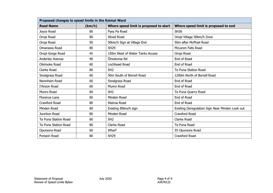
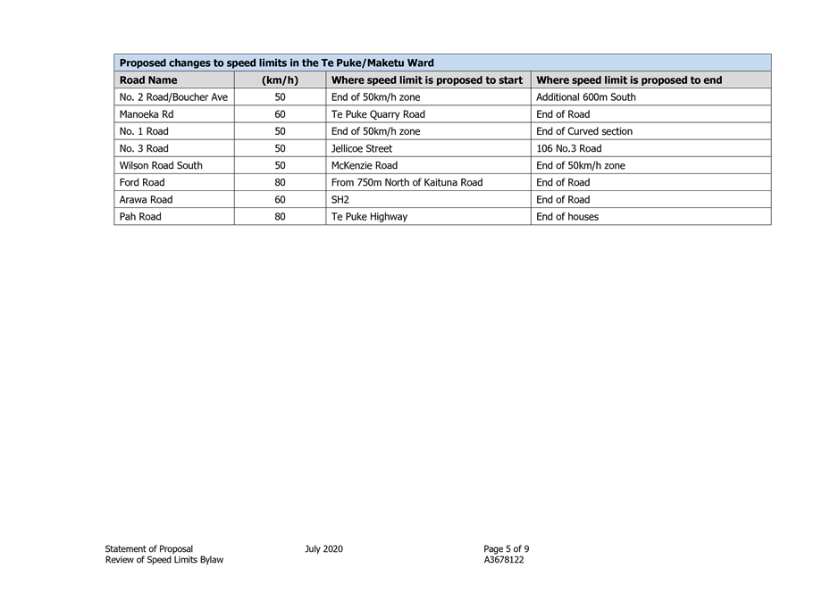
· Speed limit changes on the local road network
|
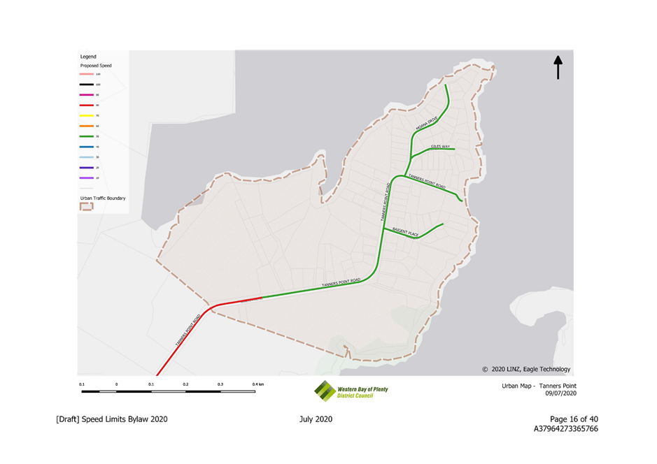
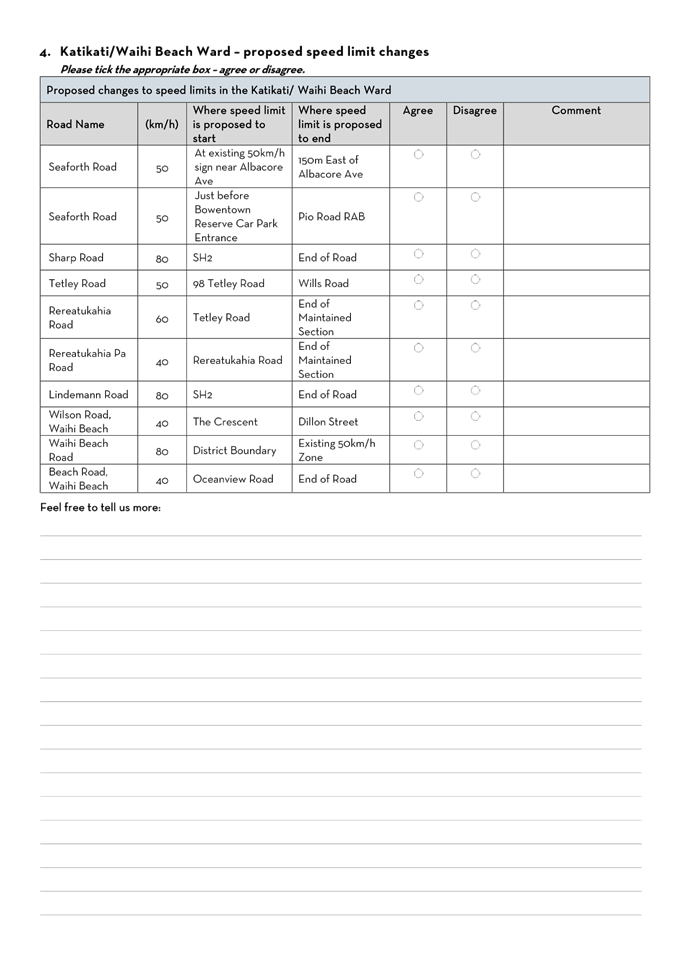
Proposed changes to speed limits in the Katikati/Waihi Beach Ward |
|||
|
Road Name |
(km/h) |
Where speed limit is proposed to start |
Where speed limit is proposed to end |
|
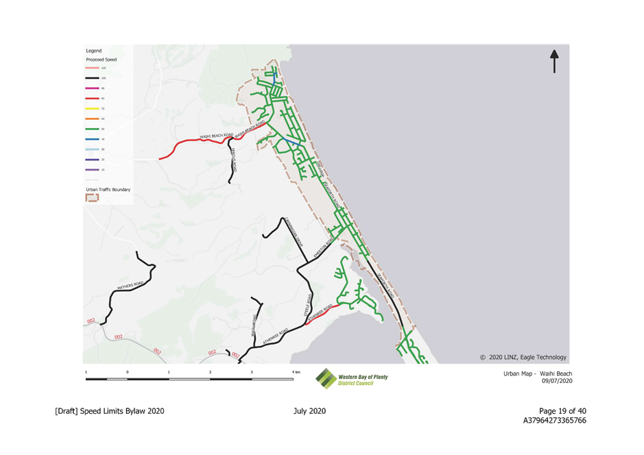
Seaforth Road |
50 |
At existing 50km/h sign near Albacore Ave |
150m East of Albacore Ave |
|
Seaforth Road |
50 |
Just before Bowentown Reserve Car Park Entrance |
Pio Road Roundabout |
|
Sharp Road |
80 |
SH2 |
End of Road |
|
Tetley Road |
50 |
98 Tetley Road |
Wills Road |
|
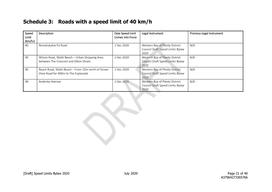
Rereatukahia Road |
60 |
Tetley Road |
End of Maintained Section |
|
Rereatukahia Pa Road |
40 |
Rereatukahia Road |
End of Maintained Section |
|
Lindemann Road |
80 |
SH2 |
End of Road |
|
Wilson Road, Waihi Beach |
40 |
The Crescent |
Dillon Street |
|
Waihi Beach Road |
80 |
District Boundary |
Existing 50km/h Zone |
|
Beach Road, Waihi Beach |
40 |
Oceanview Road |
End of Road |
We assessed all requests we have received from the community since our last review in 2015, as well as any recommendations from Community Boards, Ward Forums and other committees of Council. All requests were then subject to technical assessment in accordance with the Rule and Speed Management Guide. The proposed changes are set out below, by ward.
|
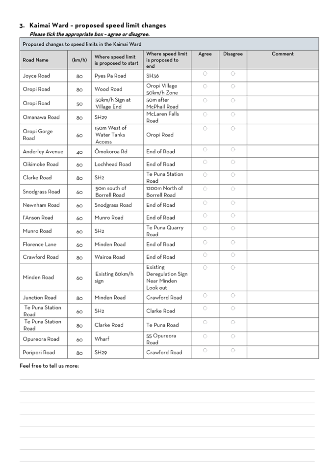
Proposed changes to speed limits in the Kaimai Ward |
|||
|
Road Name |
(km/h) |
Where speed limit is proposed to start |
Where speed limit is proposed to end |
|
Joyce Road |
80 |
Pyes Pa Road |
SH36 |
|
Oropi Road |
80 |
Wood Road |
Oropi Village 50km/h Zone |
|
Oropi Road |
50 |
50km/h Sign at Village End |
50m after McPhail Road |
|
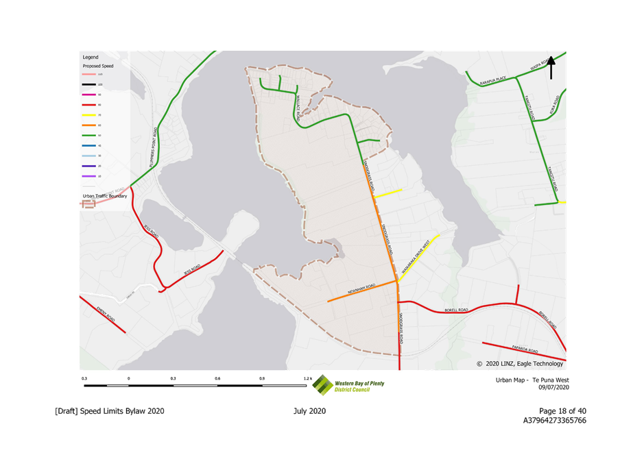
Omanawa Road |
80 |
SH29 |
McLaren Falls Road |
|
Oropi Gorge Road |
60 |
150m West of Water Tanks Access |
Oropi Road |
|
Anderley Avenue |
40 |
Ōmokoroa Rd |
End of Road |
|
Oikimoke Road |
60 |
Lochhead Road |
End of Road |
|
Clarke Road |
80 |
SH2 |
Te Puna Station Road |
|
Snodgrass Road |
60 |
50m south of Borrell Road |
1200m North of Borrell Road |
|
Newnham Road |
60 |
Snodgrass Road |
End of Road |
|
I'Anson Road |
60 |
Munro Road |
End of Road |
|
Munro Road |
60 |
SH2 |
Te Puna Quarry Road |
|
Florence Lane |
60 |
Minden Road |
End of Road |
|
Crawford Road |
80 |
Wairoa Road |
End of Road |
|
Minden Road |
60 |
Existing 80km/h sign |
Existing Deregulation Sign Near Minden Look out |
|
Junction Road |
80 |
Minden Road |
Crawford Road |
|
Te Puna Station Road |
60 |
SH2 |
Clarke Road |
|
Te Puna Station Road |
80 |
Clarke Road |
Te Puna Road |
|
Opureora Road |
60 |
Wharf |
55 Opureora Road |
|
Poripori Road |
80 |
SH29 |
Crawford Road |
|
Proposed changes to speed limits in the Te Puke/Maketu Ward |
|||
|
Road Name |
(km/h) |
Where speed limit is proposed to start |
Where speed limit is proposed to end |
|
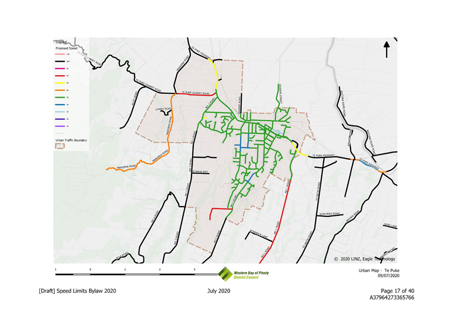
No. 2 Road/Boucher Ave |
50 |
End of 50km/h zone |
Additional 600m South |
|
Manoeka Rd |
60 |
Te Puke Quarry Road |
End of Road |
|
No. 1 Road |
50 |
End of 50km/h zone |
End of Curved section |
|
No. 3 Road |
50 |
Jellicoe Street |
106 No.3 Road |
|
Wilson Road South |
50 |
McKenzie Road |
End of 50km/h zone |
|
Ford Road |
80 |
From 750m north of Kaituna Road |
End of Road |
|
Arawa Road |
60 |
SH2 |
End of Road |
|
Pah Road |
80 |
Te Puke Highway |
End of houses |
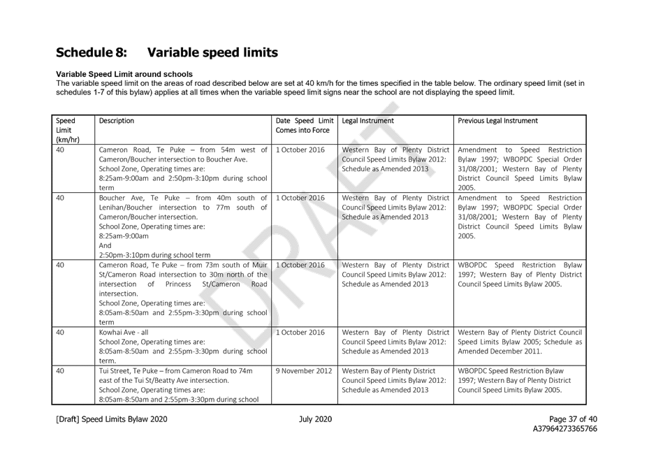
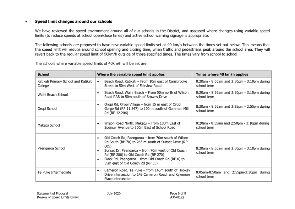
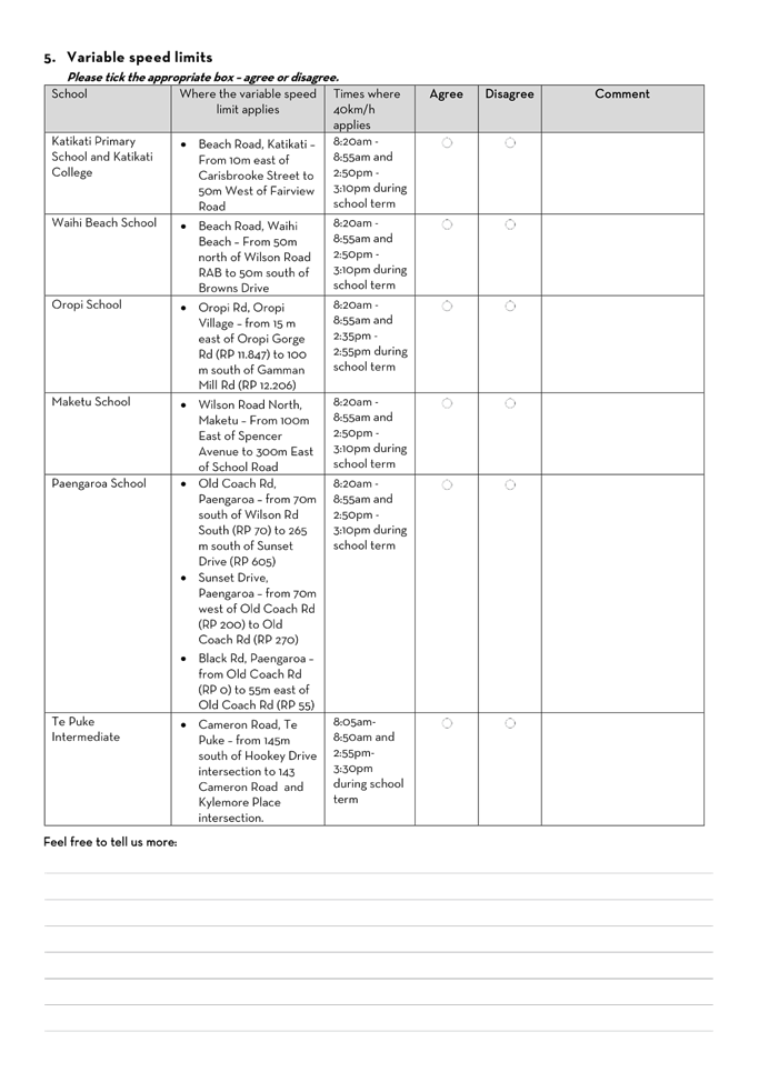
· Speed limit changes around our schools
We have reviewed the speed environment around all of our schools in the District, and assessed where changes using variable speed limits (to reduce speeds at school open/close times) and active school warning signage is appropriate.
The following schools are proposed to have new variable speed limits set at 40 km/h between the times set out below. This means that the speed limit will reduce around school opening and closing time, when traffic and pedestrians peak around the school area. They will revert back to the regular speed limit of 50km/h outside of those specified times. The times vary from school to school.
The schools where variable speed limits of 40km/h are proposed are:
|
School |
Where the variable speed limit applies |
Times where 40 km/h applies |
|
Katikati Primary School and Katikati College |
· Beach Road, Katikati – From 10m east of Carisbrooke Street to 50m West of Fairview Road |
8:20am - 8:55am and 2:50pm - 3:10pm during school term |
|
Waihi Beach School |
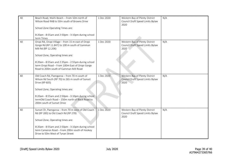
· Beach Road, Waihi Beach – From 50m north of Wilson Road RAB to 50m south of Browns Drive |
8:20am - 8:55am and 2:50pm - 3:10pm during school term |
|
Oropi School |
· Oropi Rd, Oropi Village – from 15 m east of Oropi Gorge Rd (RP 11.847) to 100 m south of Gamman Mill Rd (RP 12.206) |
8:20am - 8:55am and 2:35pm - 2:55pm during school term |
|
Maketu School |
· Wilson Road North, Maketu – From 100m East of Spencer Avenue to 300m East of School Road |
8:20am - 8:55am and 2:50pm - 3:10pm during school term |
|
Paengaroa School
|
· Old Coach Rd, Paengaroa – from 70m south of Wilson Rd South (RP 70) to 265 m south of Sunset Drive (RP 605) · Sunset Dr, Paengaroa – from 70m west of Old Coach Rd (RP 200) to Old Coach Rd (RP 270) · Black Rd, Paengaroa – from Old Coach Rd (RP 0) to 55m east of Old Coach Rd (RP 55) |
8:20am - 8:55am and 2:50pm - 3:10pm during school term |
|
Te Puke Intermediate
|
· Cameron Road, Te Puke – from 145m south of Hookey Drive intersection to 143 Cameron Road and Kylemore Place intersection. |
8:05am-8:50am and 2:55pm-3:30pm during school term |
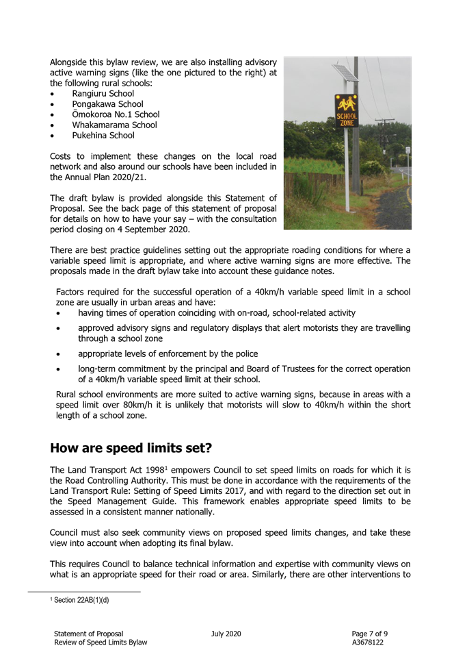
Alongside the bylaw review, it is proposed to install active warning signs at the following schools. These are advisory only and do not set a variable speed limit.
o Rangiuru School
o Pongakawa School
o Ōmokoroa No.1 School
o Whakamarama School
o Pukehina School
There are best practice guidelines setting out the appropriate roading conditions for where a variable speed limit is appropriate, and where active warning signs are more effective. The proposals made in the draft bylaw take into account these guidance notes.
Factors required for the successful operation of a 40km/h variable speed limit in a school zone are usually in urban areas and have:
· having times of operation coinciding with on-road, school-related activity
· approved advisory signs and regulatory displays that alert motorists they are travelling through a school zone
· appropriate levels of enforcement by the police
· long-term commitment by the principal and Board of Trustees for the correct operation of a 40km/h variable speed limit at their school.
Rural school environments are more suited to active warning signs, because in areas with a speed limit over 80km/h it is unlikely that motorists will slow to 40km/h within the short length of a school zone.
Significance and Engagement
1. The Local Government Act 2002 requires a formal assessment of the significance of matters and decision in this report against Council’s Significance and Engagement Policy in order to guide decisions on approaches to engagement and the degree of options analysis. In making this formal assessment it is acknowledged that all reports have a high degree of importance to those affected by Council decisions.
In terms of the Significance and Engagement Policy this decision is considered to be of medium significance because of the requirement to undertake consultation on the draft bylaw, the number of residents affected by the proposals, the spread of proposed speed limit changes across the District and the likely level of community interest in this review process.
Engagement, Consultation and Communication
1. Consultation on the draft Speed Limits Bylaw 2020 is required by section 22AD of the Land Transport Act 1998 and section 156 of the Local Government Act 2002. Council will be undertaking a special consultative procedure pursuant to section 83 of the Local Government Act 2002 to ensure there are appropriate opportunities for the community and key stakeholders to have their say on the proposed speed limit changes.
|
Interested/Affected Parties |
Planned Consultation
|
|
Name of interested parties/groups |
Direct email/letter to notify the following parties of the consultation period and how to provide feedback: · School principals where variable speed limits and active warning signs are proposed. · NZTA, Westlink, Tauranga City Council, NZ Police. |
|
General Public |
Media release, public notice in Bay of Plenty Times and Weekend Sun, WBOPDC website information, online feedback through Have Your Say site (including story map), opportunity to register to speak to feedback, hardcopy forms available at Council libraries and service centres (and available posted on request). |
Issues and Options Assessment
|
Option A Adopt draft bylaw and associated documentation for consultation |
|
|
Assessment of advantages and disadvantages including impact on each of the four well-beings · Economic · Social · Cultural · Environmental |
Advantages: · Bylaw amendments should promote better road safety outcomes, particularly around the schools in our District. · Partial review enables Council to respond to speed limit requests where these are supported by technical assessment. · Consultation is through a special consultative procedure, which means people have a range of opportunities to share their views. Disadvantages · Does not progress a whole of road network review, which means there may be some inconsistencies of speed environments. · Further work on reviewing speed limits is signalled by legislative change, through the requirement to develop a speed management plan – although the timing for this is currently uncertain. · Outcome of NZTA speed limit review on State Highway 2 are still unknown, so may give rise to some level of inconsistency. |
|
Costs (including present and future costs, direct, indirect and contingent costs). |
Bylaw review costs can be met within existing budgets. Implementation costs for signage have been included in the Annual Plan 2020/21. |
|
Option B Do not adopt the draft bylaw and associated documentation for consultation |
|
|
Assessment of advantages and disadvantages including impact on each of the four well-beings · Economic · Social · Cultural · Environmental |
Advantages · Other work can be progressed in lieu of this bylaw review. · Speed limit changes can be referred to the future speed management plan review. · Outcomes of NZTA’s State Highway Two speed limit review can be incorporated, depending on timing. · A whole of network review can be progressed, potentially enabling more consistent speed environments. Disadvantages · No response to community speed limit change requests in the near future. · Could be perceived as a missed opportunity to promote better road safety outcomes, particularly around the schools in our District. |
|
Costs (including present and future costs, direct, indirect and contingent costs). |
Costs to progress the review and implement the signage required to legitimise speed limit changes will not be incurred. |
Statutory Compliance
1. The recommendations of this report are consistent with the Land Transport Act 1998 and Local Government Act 2002 requirements for bylaw reviews.
Funding/Budget Implications
1. There are no unbudgeted financial implications arising from the recommendations of this report.
|
Budget Funding Information |
Relevant Detail |
|
Bylaw review |
Costs associated with the consultation process can be met within existing policy and planning budgets. |
|
Implementation funding |
Implementation funding has been included in the Annual Plan 2020/21. |
1. Attachment
1 - Draft Speed Limits Bylaw 2020 ⇩ ![]()
2. Attachment
2 - Statement of Proposal - Draft Speed Limits Bylaw 2020 ⇩ ![]()
3. Attachment
3 - Submission Form - Draft Speed Limits Bylaw 2020 ⇩ ![]()
|
28 July 2020 |
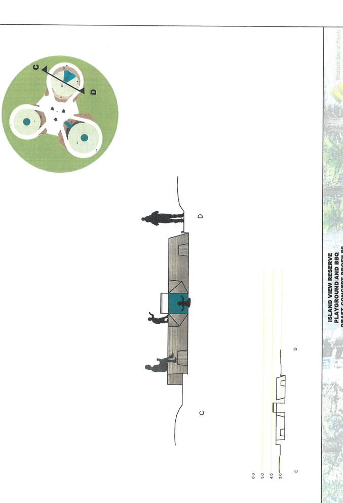
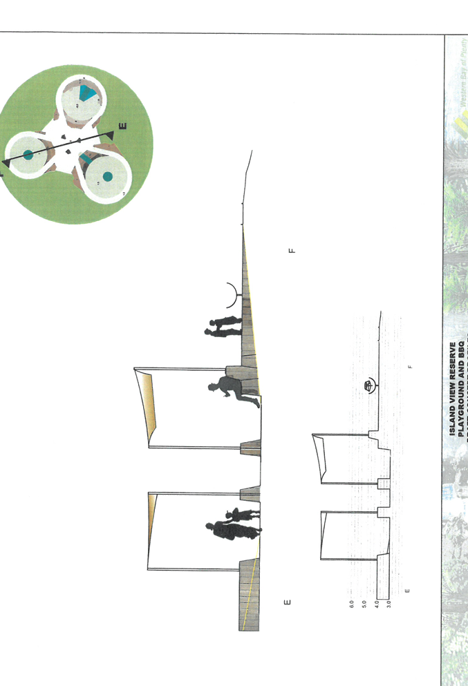
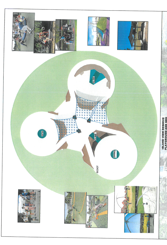
9.3 ISLAND VIEW RESERVE - PLAYGROUND AND BBQ DRAFT CONCEPT PLAN
File Number: A3796320
Author: Scott Parker, Reserves and Facilities Projects Assets Manager
Authoriser: Gary Allis, Deputy Chief Executive
Executive Summary
Council staff presented the draft Island View Reserve - Playground and BBQ Concept Plan to the Waihi Beach Community Board meeting on 8 June 2020.
The Board resolved, “that the Waihi Beach Community Board recommend to the Policy Committee that approval be given to publicly consult on the draft Island View Reserve - Playground and BBQ Concept Plan”. Attachment 2
Approval is now sought to publicly consult the draft Island View Reserve Playground and BBQ Concept Plan.
|
1. That the ISLAND VIEW RESERVE - PLAYGROUND AND BBQ DRAFT CONCEPT PLAN report by the Reserves & Facilities Projects and Assets Manager be received. 2. That the Policy Committee approves the “draft” Island View Reserve - Playground and BBQ Concept Plan for public consultation.
Or
3. That the Policy Committee approves the “draft” Island View Reserve - Playground and BBQ Concept Plan for public consultation with the following amendments……
|
Background
The Island View Reserve Playground and BBQ project is an approved Annual Plan project over the 2019/20 and 2020/21 financial years. In the 2019/20 financial year (Stage 1) the aim is to complete the concept design and obtain an Archaeological Authority or any other statutory consents associated with the project. Stage 2 in the 2020/21 financial year will conclude the design, procurement and construction.
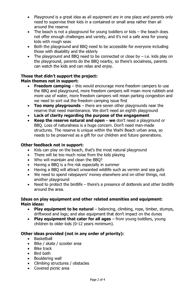
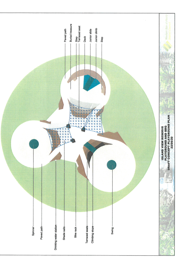
Council staff attended the Waihi Beach Community Board workshop held on 18 May 2020 to present and discuss the draft Island View Reserve Playground and BBQ Concept Plan, which was developed from the community pre-engagement feedback received between January and February 2020 Attachment 1 - Island View community engagement summary report.
Given both the positive and negative community and key stakeholder feedback received, the Board was supportive and complimentary of the draft design but wanted clarity on some of the design elements before recommending the draft concept design for release for public consultation. The matters needing clarification were addressed at the 8 June 2020 Board meeting and the Board was satisfied with the revised draft concept plan, resulting in their recommendation to publicly consult.
The points of clarity sought by the Board were responded to in the following table:
|
Board suggestion or clarification item |
Staff Response |
|
Concern about potential effects of storm-water at the proposed location |
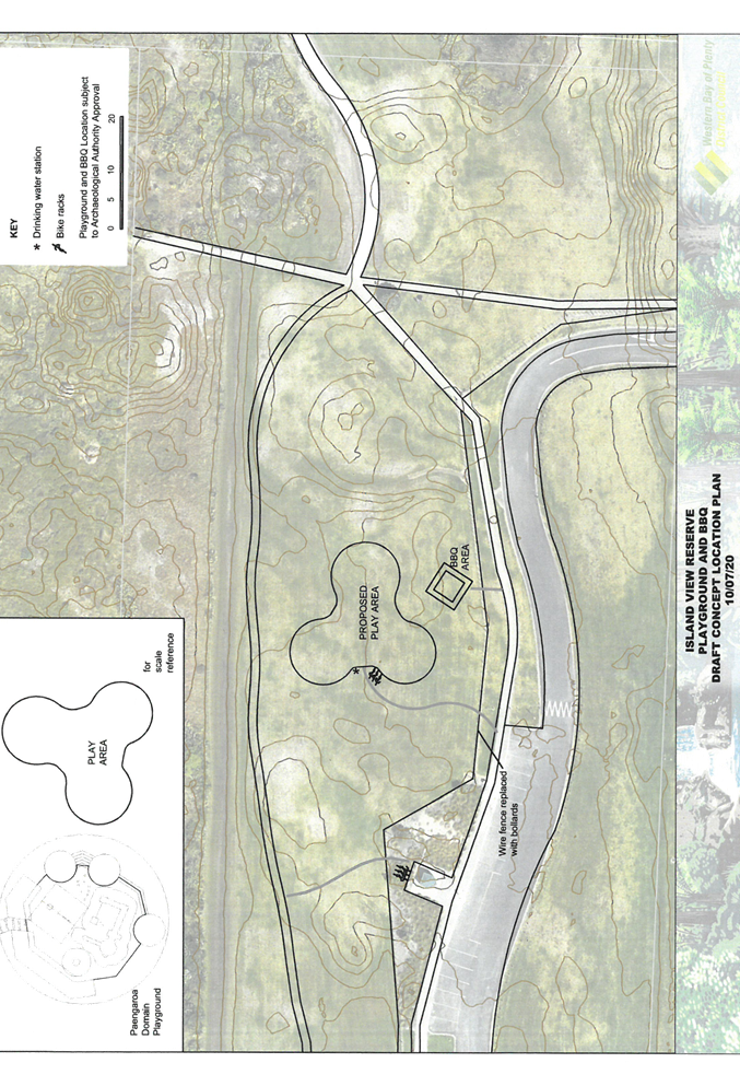
Revised plan shows contour and flood level in relation to the play zone, which is now included in the drawing set. The playground will be constructed above the flood level of Rl 2.5 m. The playground safety surface will be sand or artificial surface e.g. complying solid rubber/synthetic surface as opposed to bark, which can wash away. |
|
Concern about the shade umbrella design being strong enough for windy conditions |
Staff agree and have replaced the umbrellas with fixed shade sails |
|
Want to know more about the BBQ shade canopy |
The indicative footprint (5m x 5m) of the BBQ including shade/weather canopy is now included in the drawing set |
|
Cycleway paths & connections - concerned about potential conflict between cyclists and children playing |
Path connections and playground location relationship is now shown in the latest drawings. Staff are of the view that there is adequate separation and clear sightlines to sufficiently reduce the risk of collision. |
|
The Board wants a bike stand and a drinking fountain |
Bike stands and a drinking fountain are now shown in the draft concept (location) plan |
|
Concern about Freedom Campers using the BBQ and the cleaning and maintenance of it |
The BBQ is located deliberately away from the freedom camping area. The cleaning and maintenance of the BBQ will be added to the reserves maintenance contract. A water tap at the BBQ will assist users with cleaning the BBQ before and after use. |
Note: The final location of the playground and BBQ will be determined by the outcome of the Archaeological Authority application, which is to be considered by Heritage NZ.
Significance and Engagement
The Local Government Act 2002 requires a formal assessment of the significance of matters and decision in this report against Council’s Significance and Engagement Policy in order to guide decision on approaches of engagement and degree of options analysis. In making this formal assessment it is acknowledged that all reports have a high degree of importance to those affected by Council decisions.
In terms of the Significance and Engagement Policy this decision is considered to be of low significance because of the relatively low capital cost of the project and the robust community engagement process (which is yet to conclude).
Engagement, Consultation and Communication
Refer to the Summary community pre-engagement report. Attachment 2
|
Interested/Affected Parties |
Completed/Planned For the community engagement summary report refer Attachment 2 |
||
|
Name of interested parties/groups |
Waihi Beach School and Kohunga Reo - ongoing Waihi Beach Community Board - ongoing Department of Conservation – as landowner Note: Council has Control and Management of the reserve vested in it under a formal Gazette Notice. Heritage NZ - ongoing |
Planned |
Completed |
|
Tangata Whenua |
Te Whanau a Tauwhao Ki Otawhiwhi Contact Persons: Shaan Kingi and John Mutlow - ongoing |
||
|
General Public |
Pre-engagement completed. Further consultation on the approved draft plan required. |
||
It is proposed to undertake a one-month period of public consultation following which, the outcome of the consultation will be reported back to the Policy Committee for consideration, and where appropriate incorporation into the final design before adopting a final concept plan.
Given the extensive amount of pre-engagement, it is not intended to have a “drop in day” during the consultation period. People involved in the pre-engagement process will be provided with the “draft” concept design for final comment.
Notification of the “draft” concept design will be advertised through Council’s normal channels e.g. Council’s website.
Issues and Options Assessment
There are two options:
Option A – That the Policy Committee approves the “draft” Island View Reserve - Playground and BBQ Concept Plan for public consultation, or
Option B - That the Policy Committee approves the “draft” Island View Reserve - Playground and BBQ Concept Plan for public consultation with the following amendments……
|
Option A That the Policy Committee approves the “draft” Island View Reserve - Playground and BBQ Concept Plan for public consultation.
|
||
|
Assessment of advantages and disadvantages including impact on each of the four well-beings · Economic · Social · Cultural · Environmental |
Advantages: · The draft concept design is supported by the Community Board · Workshop clarifications have been provided in the most recent version of the draft concept plan (Attachment 2). · Avoids delay · The next round of community consultation will identify any issues without needing further changes at this early stage. · Economic sustainable design · Design in fitting with naturalness of the site · Cultural feedback remains ongoing to inform the final draft plan · Aligns with initial public engagement feedback Disadvantages: · None identified |
|
|
Costs (including present and future costs, direct, indirect and contingent costs). |
Will be maintained within forecast budgets |
|
|
Other implications and any assumptions that relate to this option (Optional – if you want to include any information not covered above). |
None identified |
|
|
Option B That the Policy Committee approves the “draft” Island View Reserve - Playground and BBQ Concept Plan for public consultation with the following amendments……
|
|
|
Assessment of advantages and disadvantages including impact on each of the four well-beings · Economic · Social · Cultural · Environmental |
Advantages: · May improve wider community acceptance of the draft design Disadvantages: · At draft concept stage, this option unnecessarily extends concept development period. |
|
Costs (including present and future costs, direct, indirect and contingent costs). |
Will be maintained within forecast budgets |
|
Other implications and any assumptions that relate to this option (Optional – if you want to include any information not covered above). |
None identified |
Statutory Compliance
This project will meet all legislative/legal requirements. It is consistent with the Katikati Waihi Beach Ward Reserve Management Plan. An Archaeological Authority is required (and currently being applied for) before any site works can commence.
Funding/Budget Implications
|
Budget Funding Information |
Relevant Detail |
|
LTP Project 237109 |
$25k for 2019/20 and $200k for 2020/21. Expenditure is on track for the current year. Achievement of the project within the allocated budget will be subject to tendered proposals received in stage 2. |
1. Island
View Reserve Playground and BBQ Project - Engagement Summary report ⇩ ![]()
2. Island
View Reserve Playground and BBQ DRAFT Concept Plans ⇩ ![]()