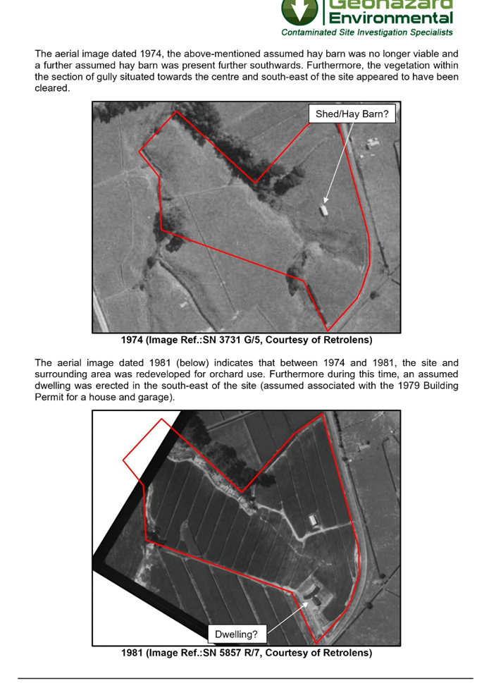
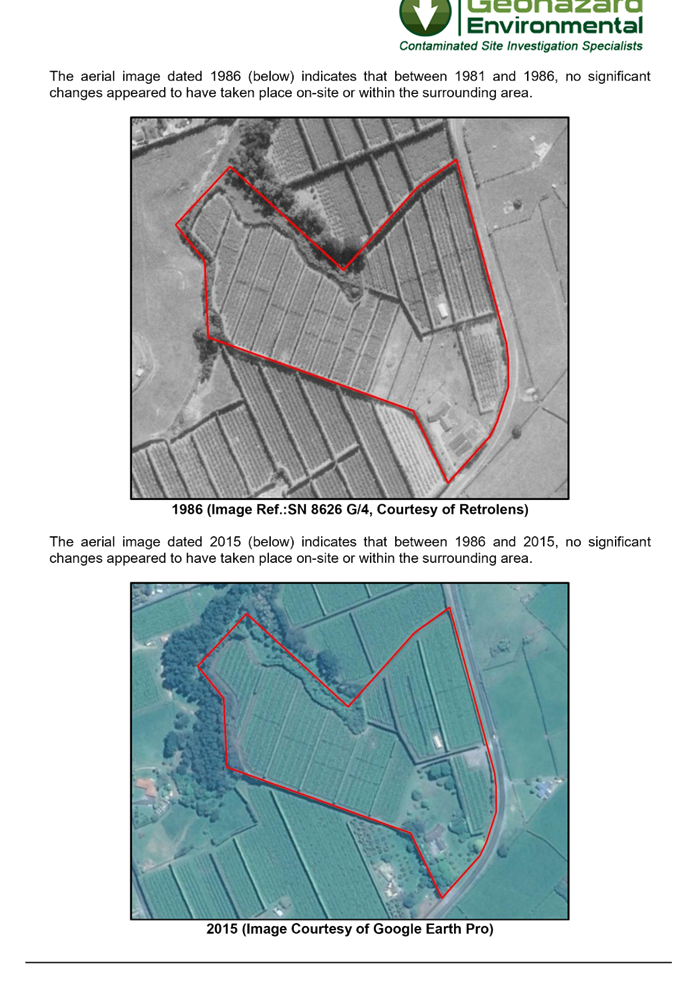
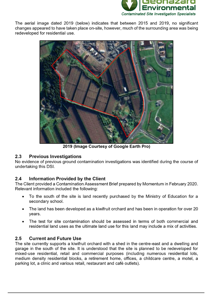
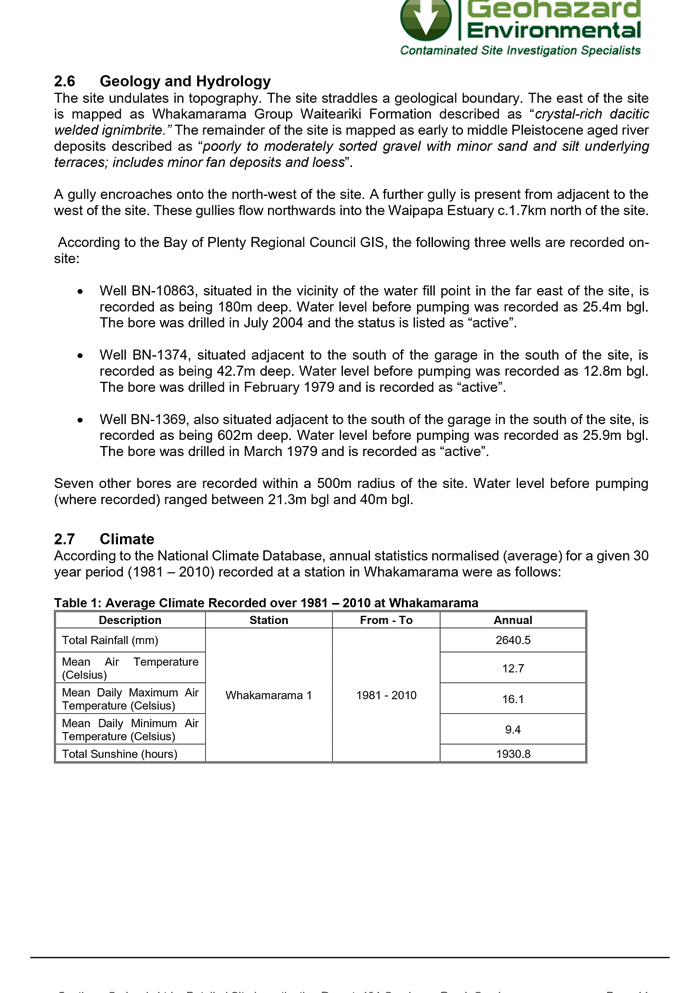
|
Independent Commissioner Hearing Komiti Whakariterite Kōrero
CH21-1 Monday, 8 March 2021 Council Chambers Barkes Corner, Tauranga 9.30am
|

|
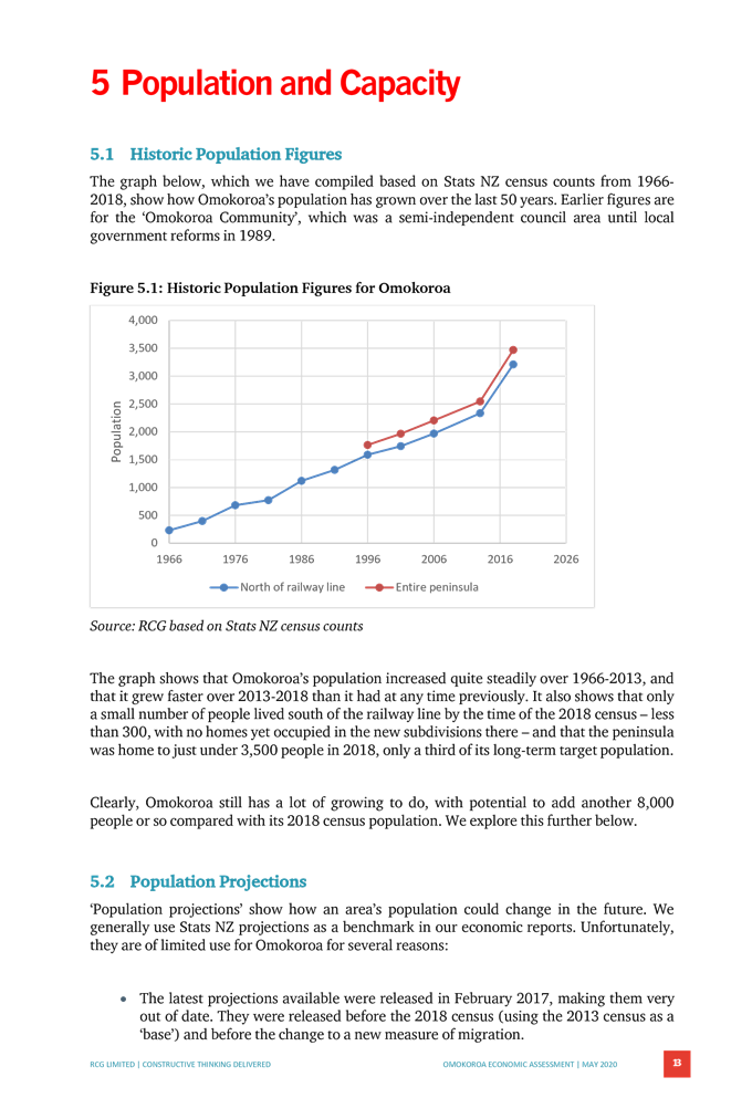
Independent Commissioner Hearing Komiti Whakariterite Kōrero
CH21-1 Monday, 8 March 2021 Council Chambers Barkes Corner, Tauranga 9.30am
|
|
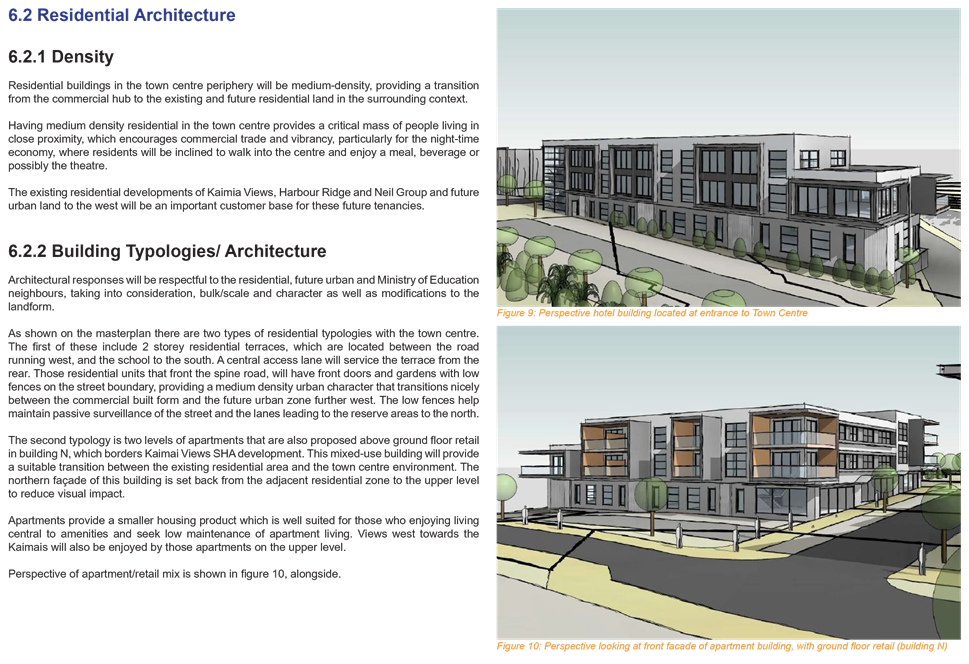
Independent Commissioner Hearing Meeting Agenda |
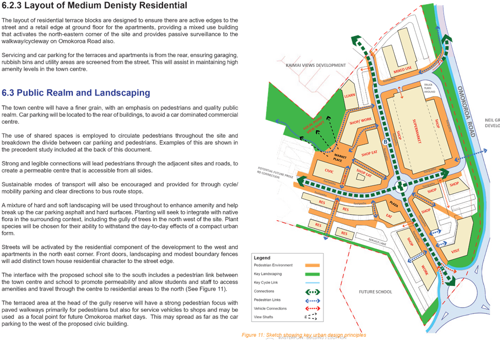
8 March 2021 |
APPOINTMENT OF COMMISSIONERS
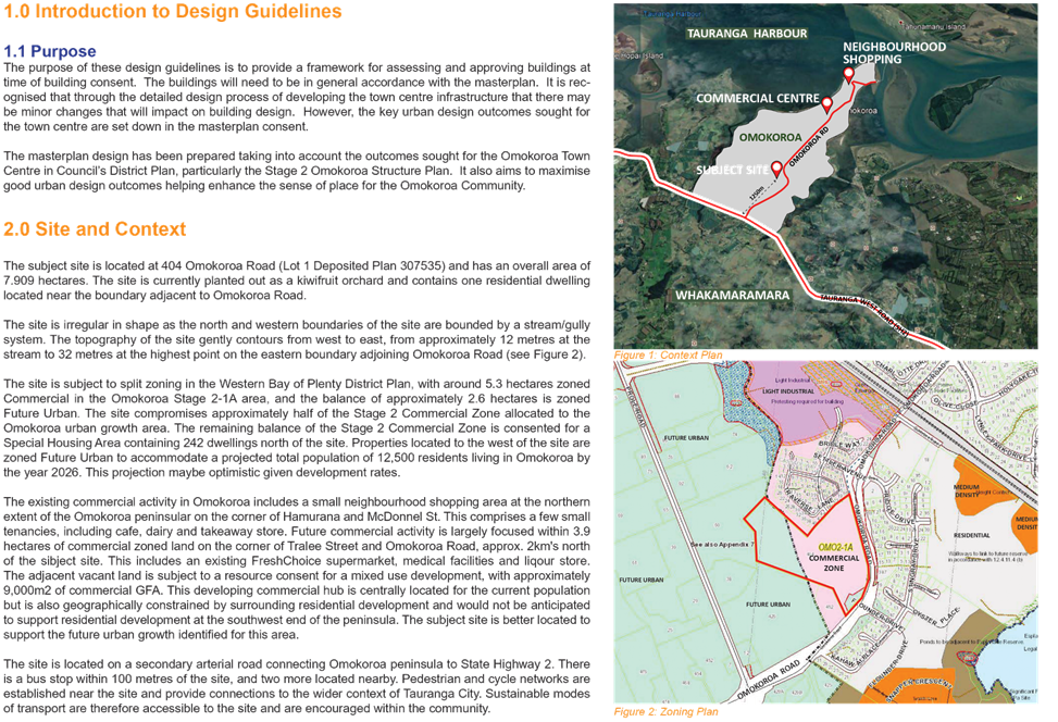
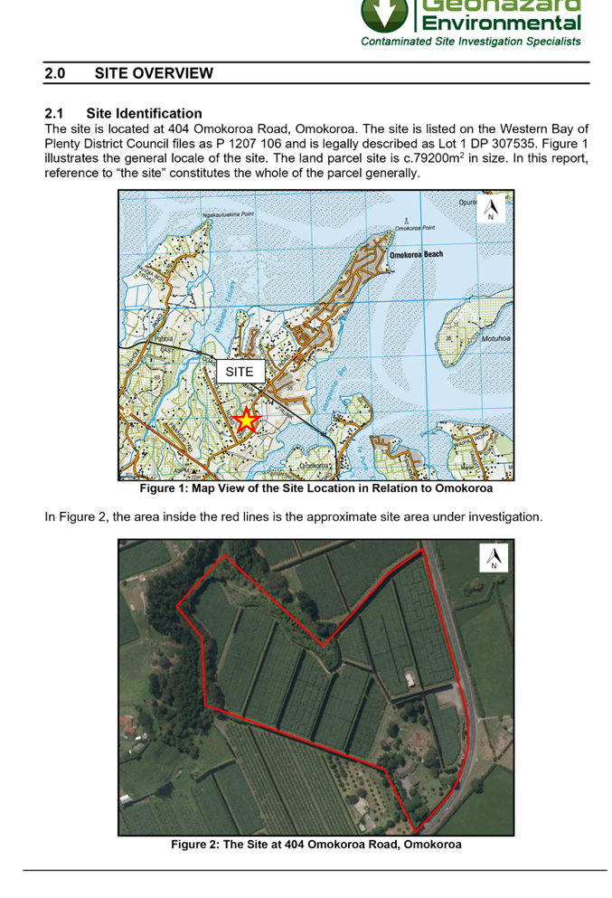
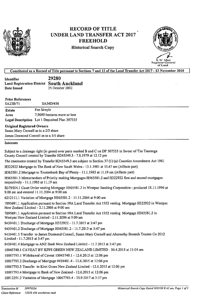
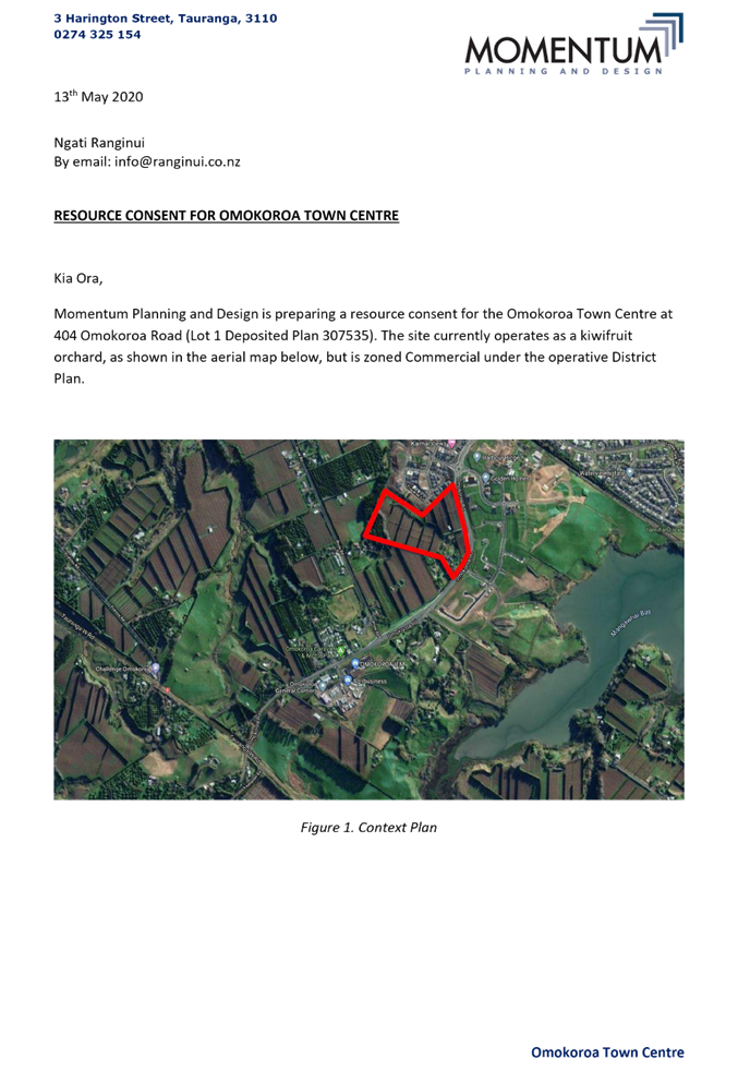
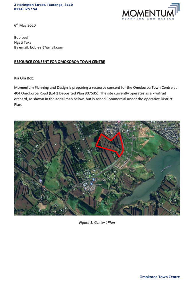
Western Bay of Plenty District Council has appointed the following Independent Hearing Commissioners to consider and determine a Resource Consent Application made by JACE investments Limited for Land Use Consent RC11997L and Subdivision Consent RC12296S to establish a Mixed-Use Commercial Town Centre at 404 Omokoroa Road, Omokoroa.
· Commissioner Jan Caunter (Chairperson)
· Commissioner David Hill
· Commissioner David Mead.
|
Independent Commissioner Hearing Meeting Agenda |
8 March 2021 |
Notice is hereby given that an Independent
Commissioner Hearing Meeting will be held in the Council Chambers, Barkes Corner, Tauranga on:
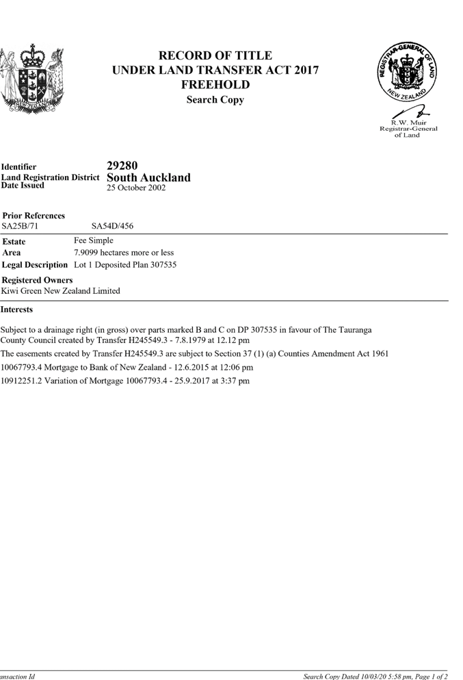
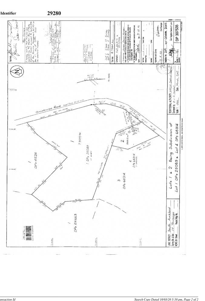
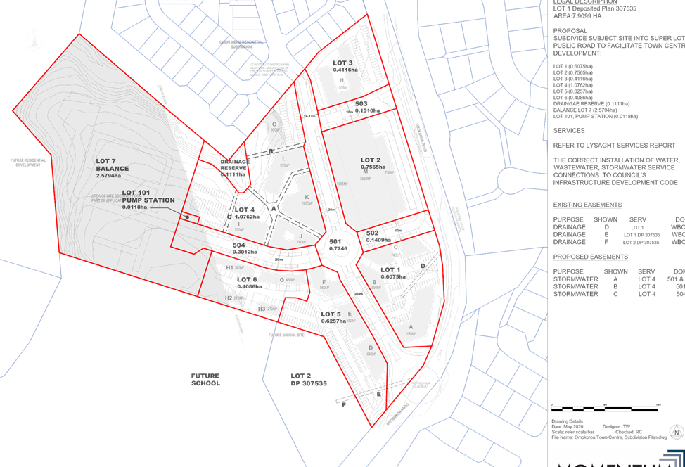
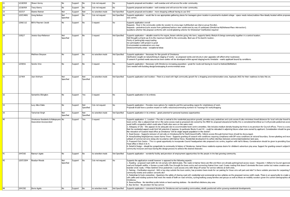
Monday, 8 March 2021 at 9.30am
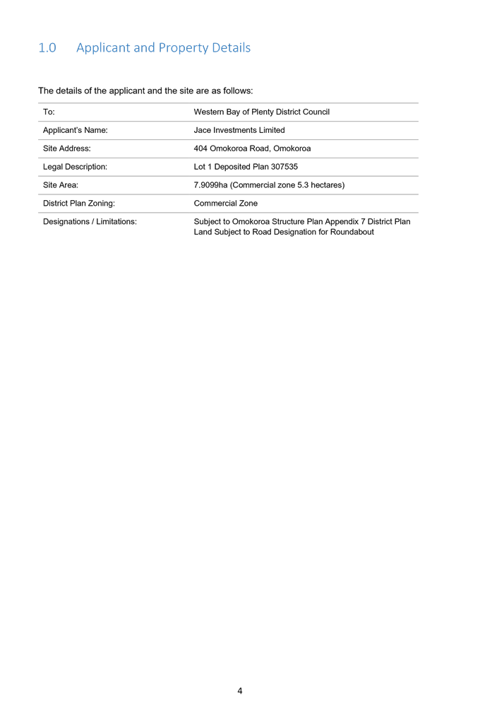
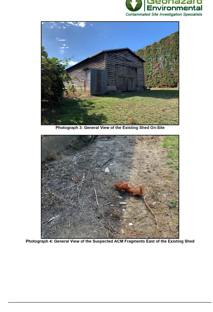
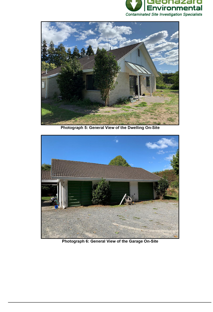
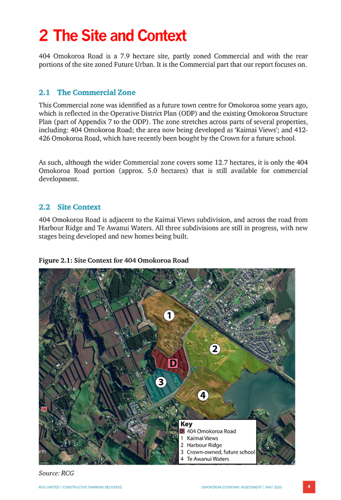
7.1 Full Application - JACE Investments Ltd - 404 Omokoroa Road, Omokoroa - RC11997L & RC2996S
|
8 March 2021 |
7.1 Full Application - JACE Investments Ltd - 404 Omokoroa Road, Omokoroa - RC11997L & RC2996S
File Number: A3995331
Author: Barbara Clarke, Senior Governance Advisor
Authoriser: Jan Pedersen, Group Manager People And Customer Services
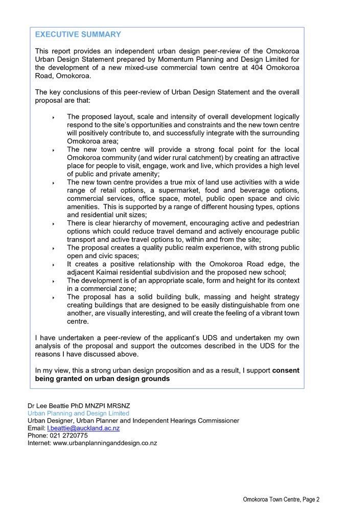
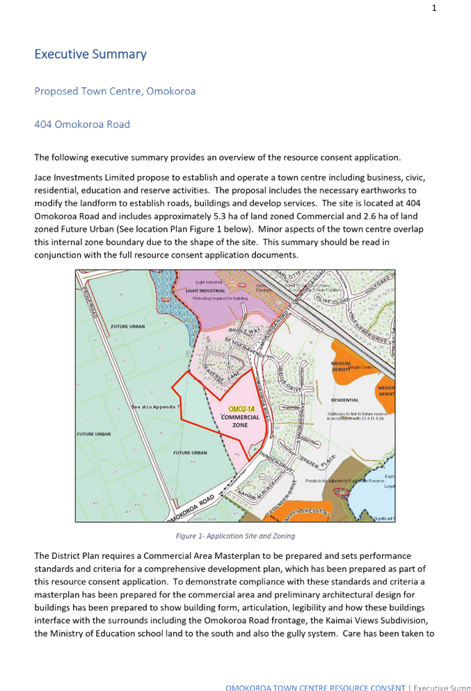
Executive Summary
This report attaches the full Application made by JACE Investments Ltd (the Applicant), for a Land Use and Subdivision Consent to establish a non-complying, Commercial zoned ‘Mixed-Use’ Commercial ‘Town Centre’ development. This development would include office, retail/commercial precinct, medium density residential units and apartments, and visitor accommodation.
1. Application
Cover letter to WBOPDC ⇩ ![]()
2. Application
Form ⇩ ![]()
3. Assessment
of Environmental Effects - Application Report ⇩ ![]()
4. Appendix
1 - Record of Title ⇩ ![]()
5. Appendix
2 - Omokoroa Town Centre Master Plan ⇩ ![]()
6. Appendix
3 - Architectural Plans (full set) ⇩ ![]()
7. Appendix
4 - Urban Design Statement ⇩ ![]()
8. Appendix
5 - Urban Design Peer Review ⇩ ![]()
9. Appendix
6 - Services Report ⇩ ![]()
10. Appendix
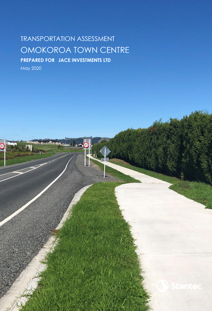
7 - Transportation Assessment ⇩ ![]()
11. Appendix
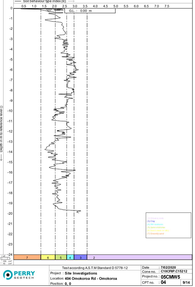
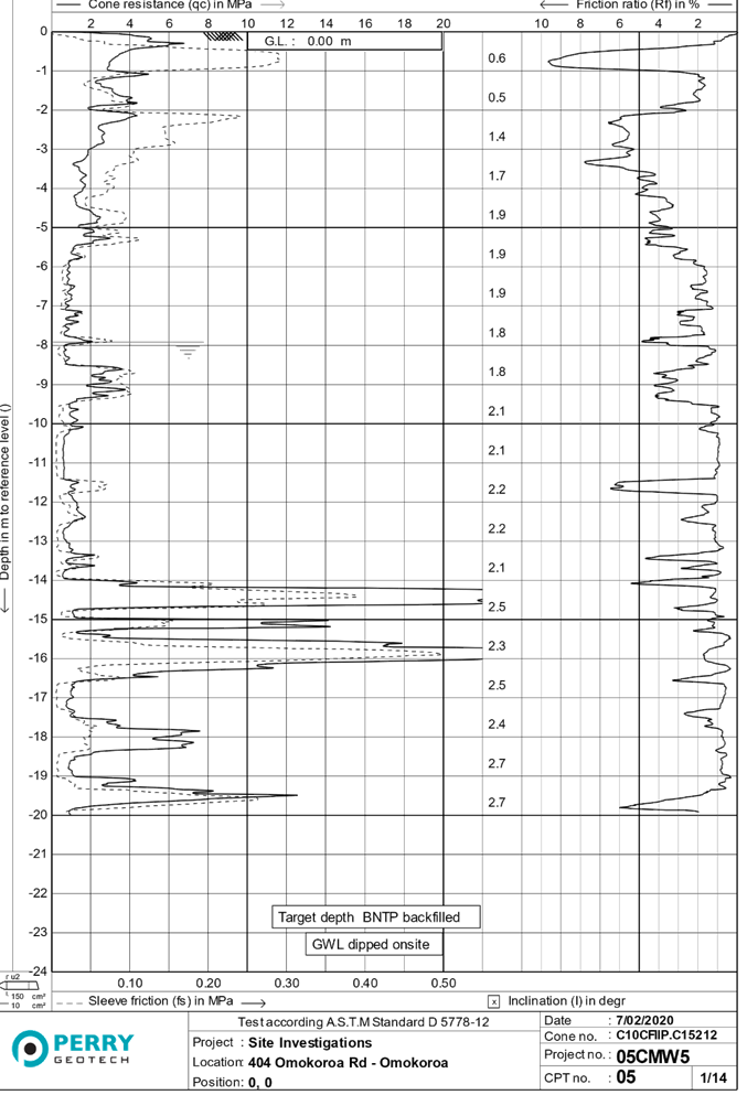
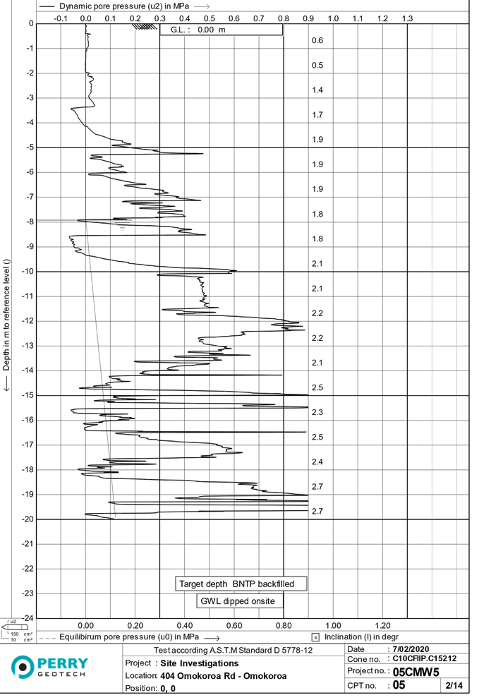
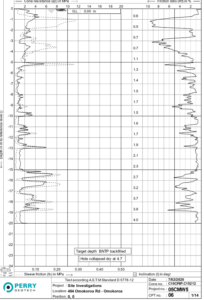
8 - Geotechnical Report ⇩ ![]()
12. Appendix
9 - Detail Site Investigation (revised) ⇩ ![]()
13. Appendix
10 - Economic Report ⇩ ![]()
14. Appendix
11 - Archaeological Report ⇩ ![]()
15. Appendix
12 - Consulation with Utility Provider ⇩ ![]()
16. Appendix
13 - Iwi & Hapu Consultation Letters ⇩ ![]()
17. Appendix
14 - Subdivision Scheme Plan ⇩ ![]()
18. Notification
Executive Summary ⇩ ![]()
|
8 March 2021 |
7.2 RC11997L & RC2996S - JACE Investments Ltd - 404 Ōmokoroa Road, Ōmokoroa - Land Use and Subdivision Consent to Establish a Mixed-Use Commercial Town Centre
File Number: A3981334
Author: Anna Price, Senior Consents Planner
Authoriser: Rachael Davie, Group Manager Policy Planning And Regulatory Services
Applicant: JACE Investments Ltd
Owner: Kiwi Green New Zealand Ltd
Executive Summary
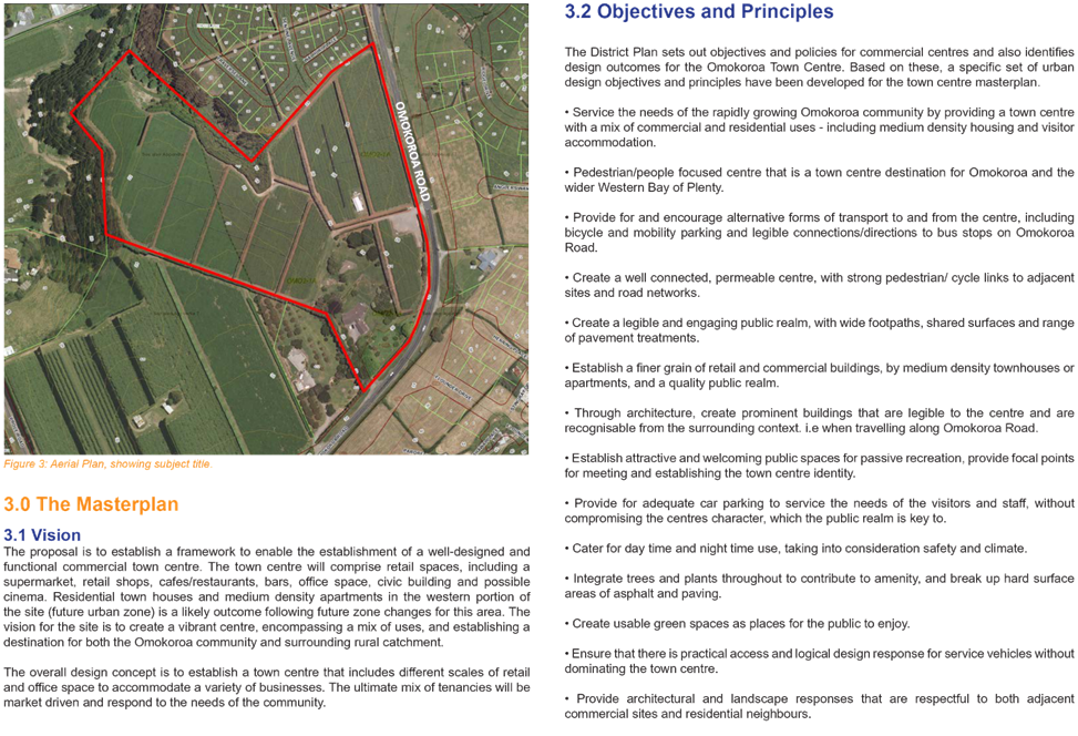
1. This report provides an assessment of the resource management issues with respect to a comprehensive land use and subdivision consent application to establish a large mixed-use commercial town centre on commercial zoned land at Ōmokoroa. The vision is to create a vibrant Town Centre including business, civic, mixed-density residential, education and recreational/reserve activities. The proposal includes significant earthworks to modify the landform and establish roads, buildings and services. The proposal is a non-complying activity.
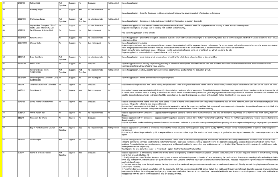
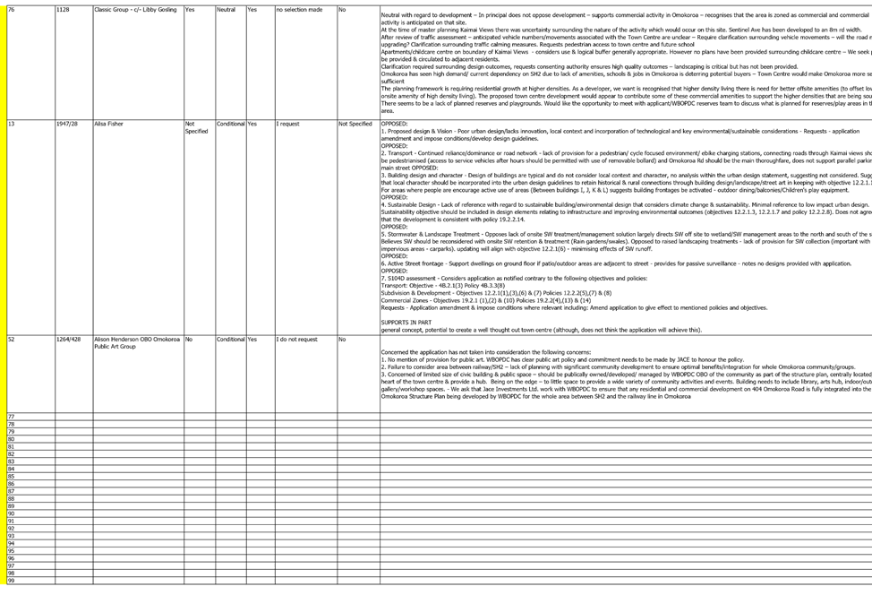
2. The application was received by Council on 21 June 2020 and has been processed on a publicly notified basis at the request of the applicant. In total 76 submissions were received within the statutory time period (20 working days), 46 submissions in support, 19 in opposition, 7 neutral, 6 conditional and 2 not specified.
3. Further information was requested at the time of public notification and a further s92 request following the close of the submission period.
4. In having regard to the submissions and the proposal, the key issues considered relate to traffic and road design, earthworks, urban design and character and amenity.
5. Having considered the proposal this report makes the recommendation to grant consent to the application.
|
1. That the Senior Consents Planner’s report dated 12 February 2021, titled ‘RC11997L & RC2996S - JACE Investments Ltd - 404 Ōmokoroa Road, Ōmokoroa - Land Use and Subdivision Consent to Establish a Mixed-Use Commercial Town Centre’, be received. 2. That pursuant to Sections 34A, 104, 104B, 104D of the Resource Management Act 1991 and Regulation 11 of the National Environmental Standard for Assessing and Managing Contaminants in Soil to Protect Human Health Regulations 2011, the Independent Hearings Commissioners, on behalf of the Western Bay of Plenty District Council, grant consent to the application by JACE Investments Limited to established a mixed-use commercial town centre, being a non-complying activity, located at 404 Ōmokoroa Road, Ōmokoroa , legally described as Lot 1 DP 307535, SA54D/456, subject to appropriate conditions. |
Introduction
6. Although I am the Reporting Officer employed by the Council I have read the Code of Conduct for Expert Witnesses contained in the Environment Court Practice Note 2014 and have complied with that practice note in preparation of this report. I agree to comply with it in presenting this report at the hearing. The opinions and assessment within this report are within my area of expertise, except where I have stated my reliance on other identified information. I have considered all material facts that are known to me that might alter or detract from the opinions that I express in this evidence.
7. This report has been prepared by Anna Price. I am a Senior Consents Planner with Western Bay of Plenty District Council (WBOPDC), a position I have held for the last five years. I have a Bachelor and Master of Earth Sciences Degrees from the University of Waikato (2005, 2007), and I am an associate member of New Zealand Planning Institute (NZPI). I have 15 years of professional experience in the resource management field, both in Local Government and private consultancy.
8. This report is a section 42A Report prepared under the Resource Management Act 1991 (RMA) which provides my advice and recommendations as an officer of the Council. The report has been prepared on the basis of the application and s92 response information available on 9 October 2020. It does not represent any decision on the applications and the conclusions and recommendations reached in the report are not binding on the Hearing Commissioners. The report will be considered by the Commissioners in conjunction with all other technical evidence and submissions to the applications to form and make a decision under delegated authority on behalf of Western Bay of Plenty District Council as the consenting authority.
9. In this report, I will outline the statutory planning framework insofar as it relates to the proposal. I will provide my assessment under section 104 of the RMA, and in doing so I will identify the issues raised through the notification process and will assess the effects of the proposal (both adverse and positive) and the effectiveness of mitigation measures proposed by the applicant. The report draws on specialist advice concerning traffic, visual and landscape and urban design which the consent authority has sought to assist the reporting officer and the Hearing Commissioners. Throughout this report I have relied on these technical experts’ reviews and assessments. The specialists’ technical assessments are attached as numbered appendices as follows:
|
Processing Team |
Personnel |
Technical Expertise |
Reference |
|
WBOPDC Senior Planner |
Anna Price |
Resource Management Act |
This Report |
|
Aurecon |
Ann Fosberry |
Transportation |
Attachment 7 |
|
Boffa Miskell |
Rebecca Ryder |
Landscape/Visual |
Attachment 7 |
|
Boffa Miskell |
Morné Hugo |
Urban Design |
Attachment 7 |
|
WBOPDC |
Ken Lawton |
Development Engineering |
Within this report |
|
WBOPDC |
Bryan Norton |
Reserves |
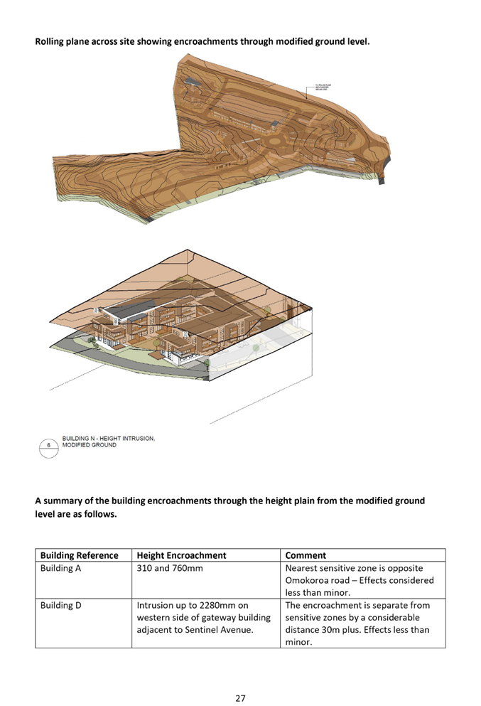
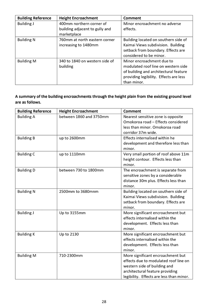
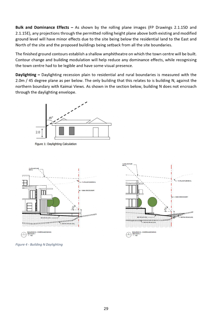
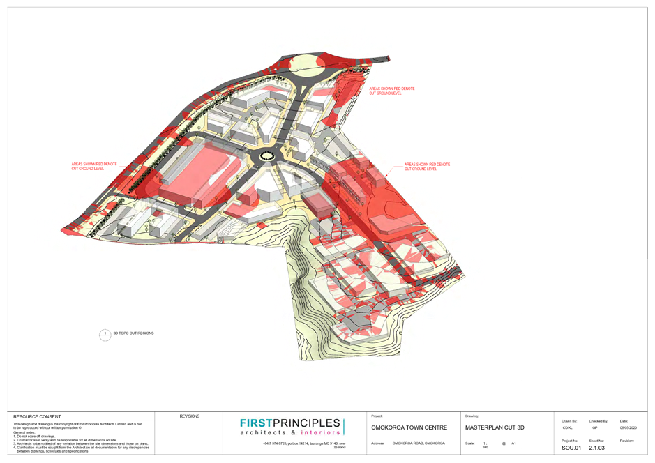
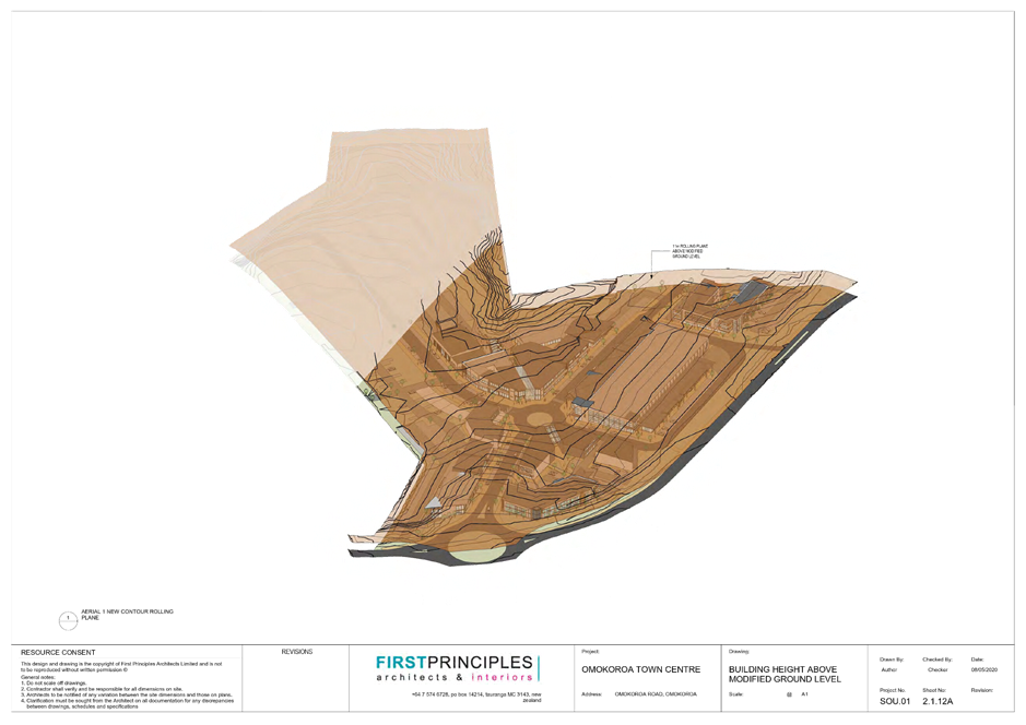
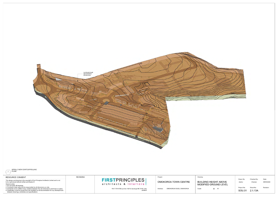
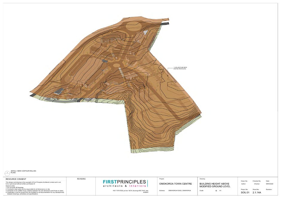
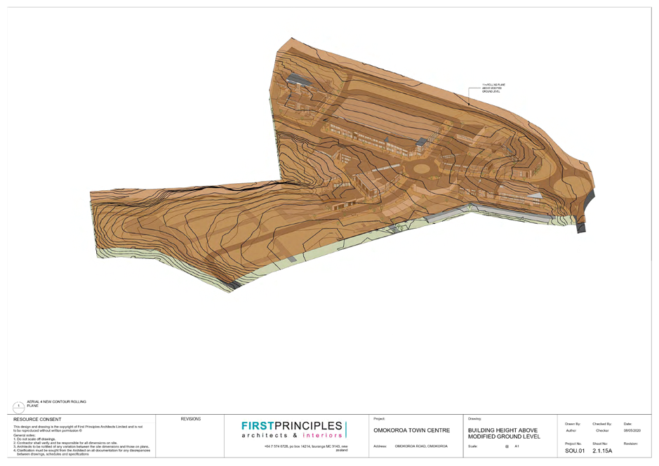
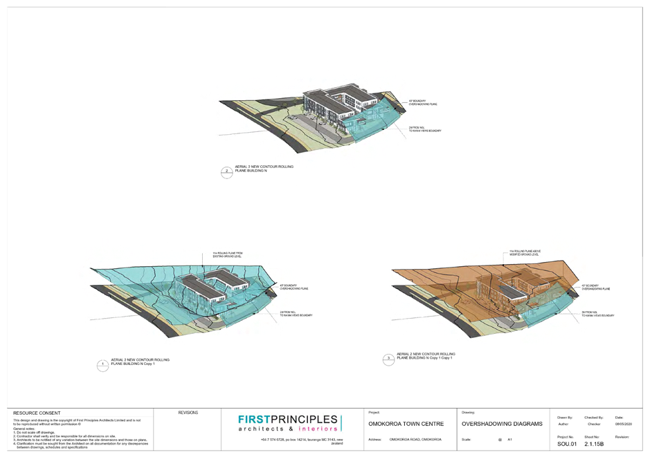
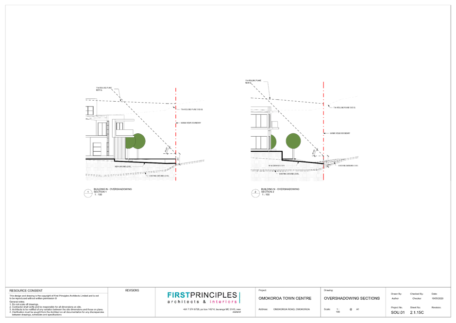
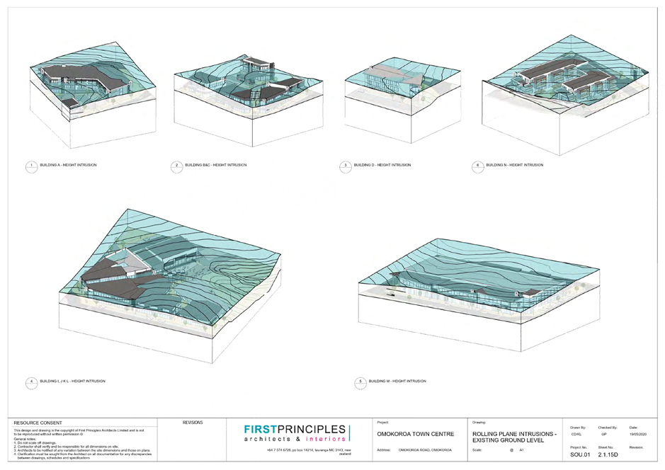
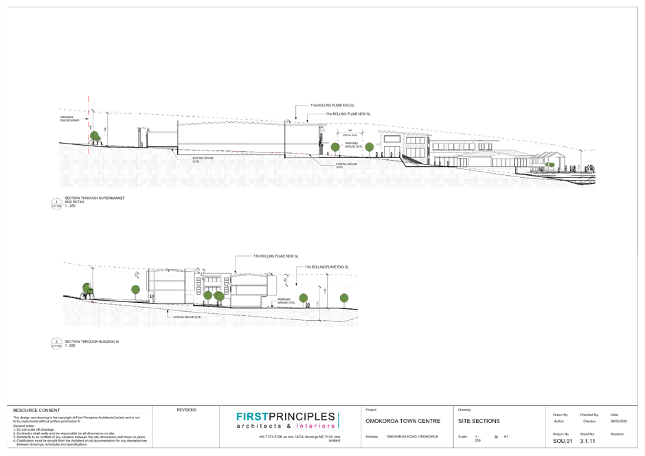
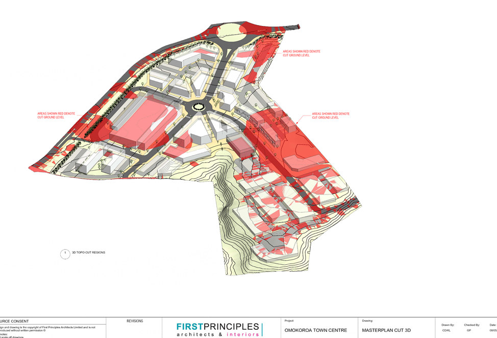
Within this report |
|
WBOPDC |
Andries Cloete |
Urban Design |
Within this report |
|
WBOPDC |
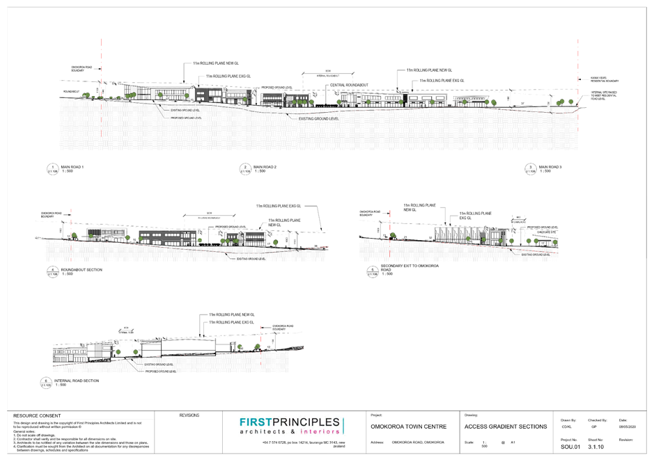
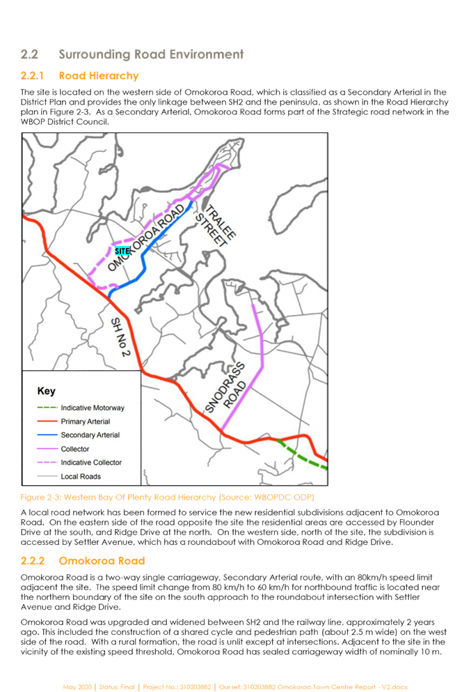
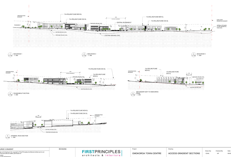
Alison Curtis |
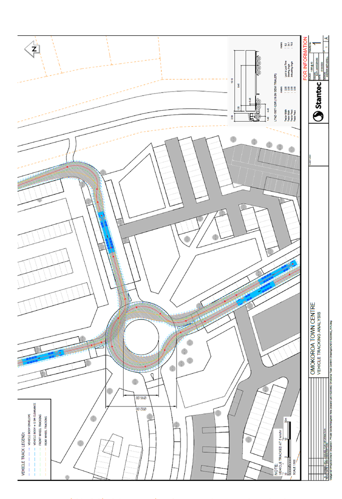
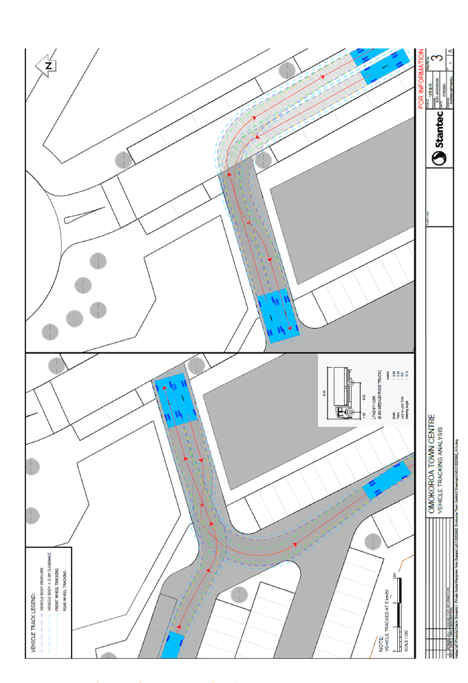
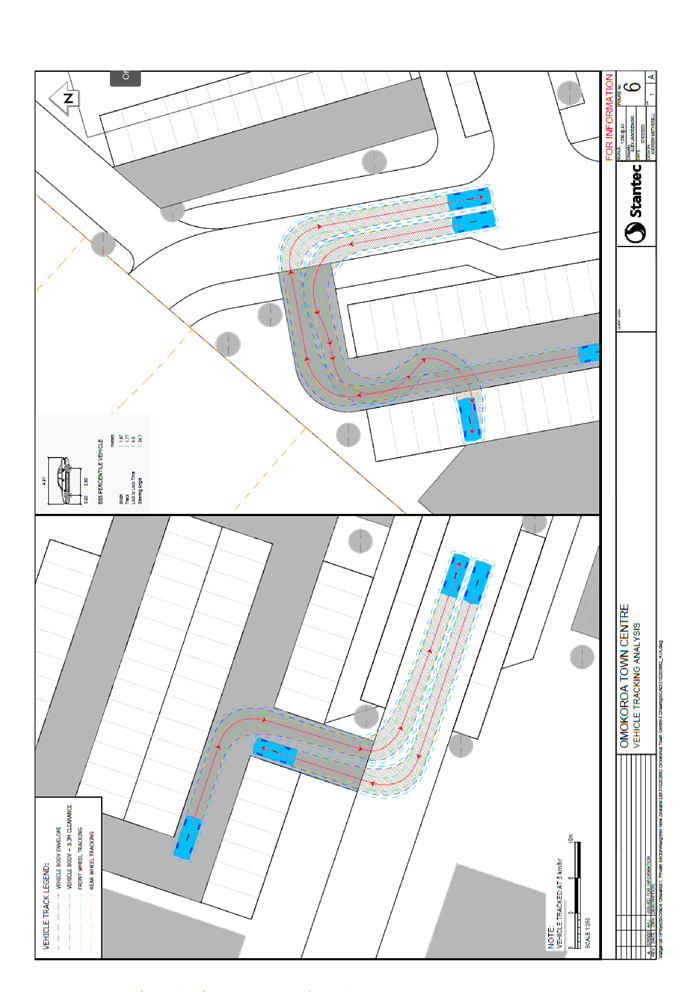
Noise |
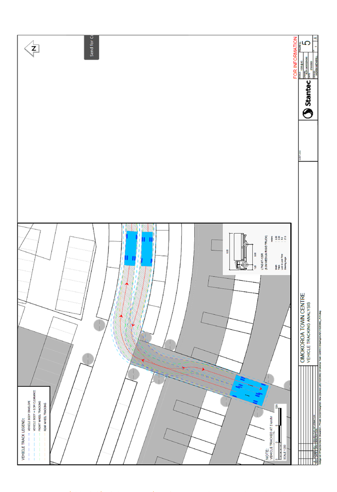
Attachment 7 |
Proposal
10. An application was received by the Western Bay of Plenty District Council (‘Council’) on 21 May 2020 to establish a mixed use commercial town centre including offices, visitor accommodation, childcare, retail, mixed-density residential, supermarket, civic, recreation and hospitality. A copy of the application is included as Attachment 1.
11. The applicant requested Public Notification. This application was publicly notified on 19 June 2020.
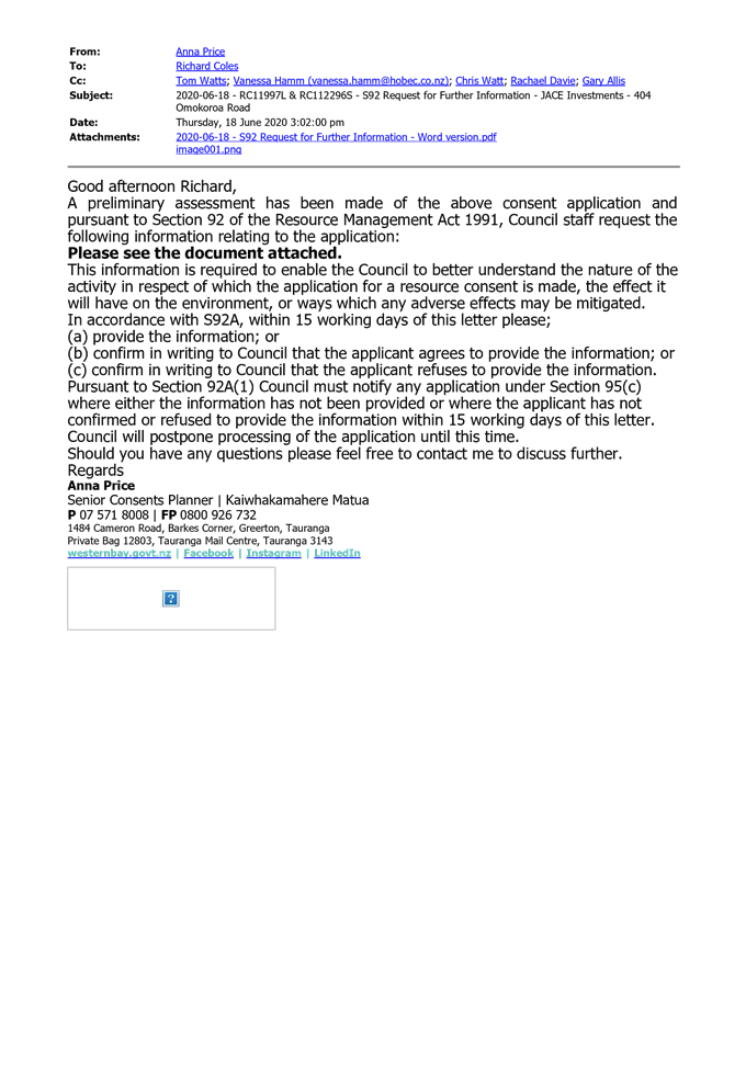
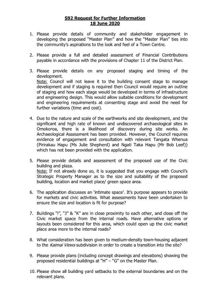
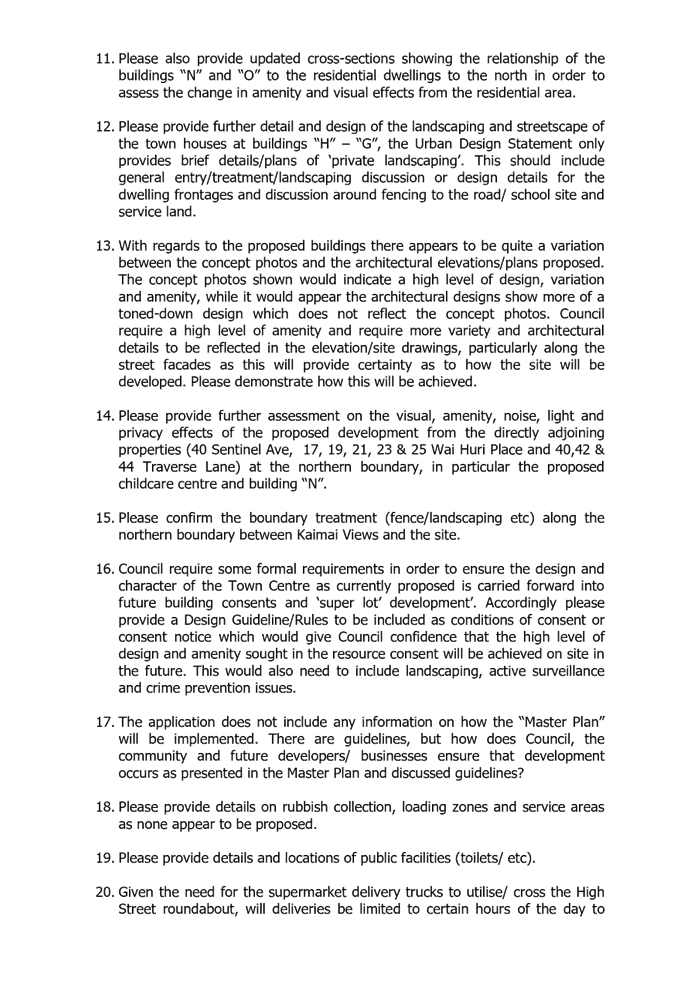
12. Further information was requested 18 June 2020, and this request is included as Attachment 3.
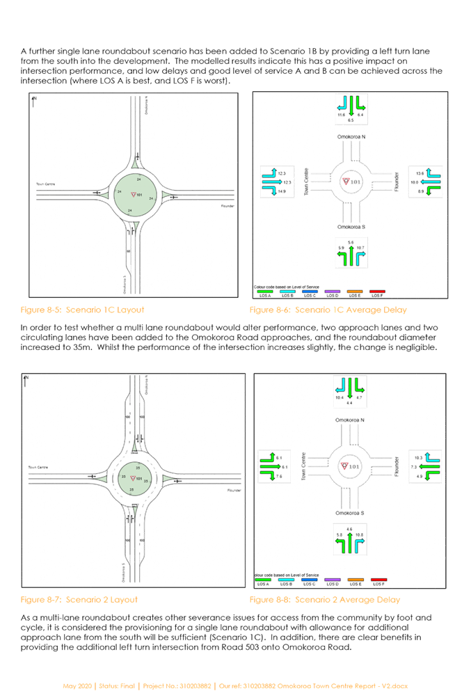
13. The applicant proposes:
· The creation of a mixed use “Town Centre” development on 5.3ha of commercial zoned land on the site with a balance area of 2.6ha zoned future urban. The site is lower than Ōmokoroa Road and drops away towards the gully in the north-west of the site;
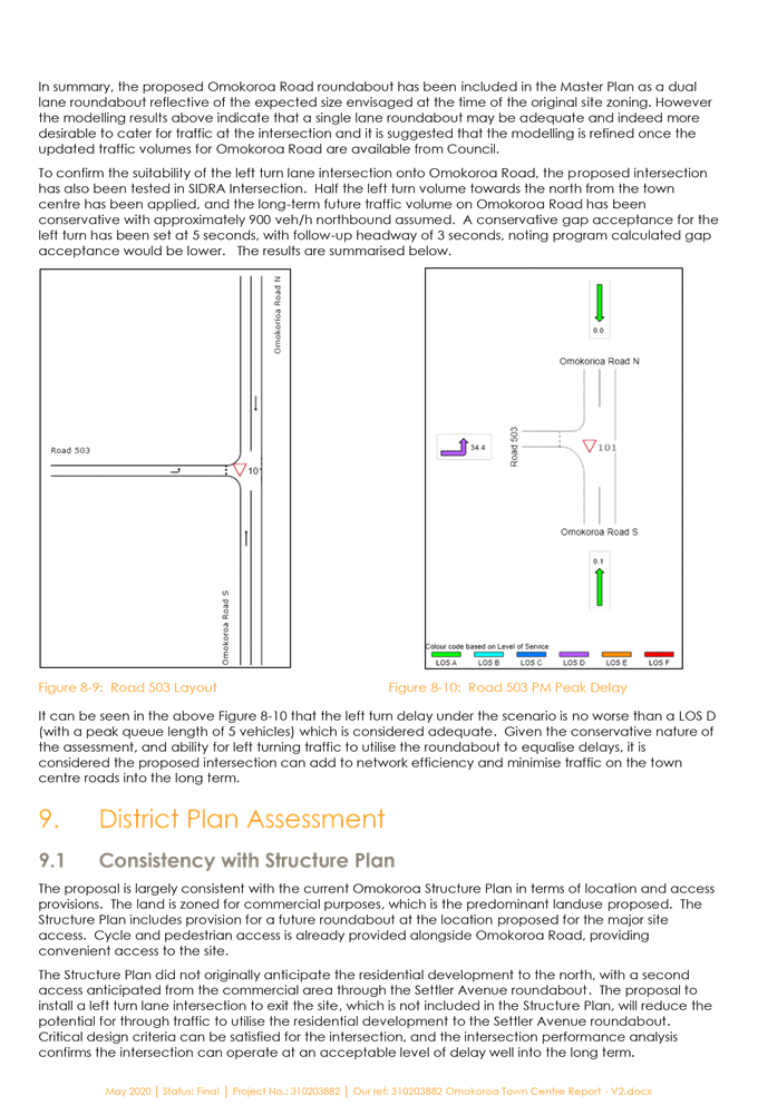
· The application includes development of a Master Plan for the commercial zoned land to allow for the mixed use development.
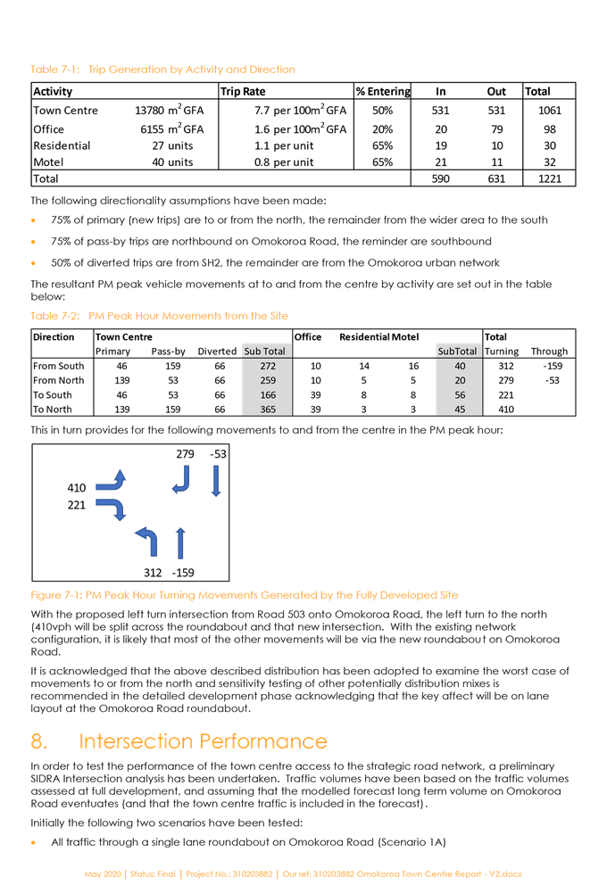
· The development includes approximately 50,000m3 of earthworks to modify the landform
· The development is proposed to proceed over 4 stages
· Stage one includes all bulk earthworks, establishment of super lots 1, 2 & 3 and roads to vest in Council. The proposed pump station will be established and the intersection will be created at Ōmokoroa Road. This includes the motel/ hotel, retail/ office, proposed supermarket, ribbon retail and apartment building;
· Stage Two involves the establishment of Lot 5 and associated infrastructure. This includes two storey retail/office buildings and café/restaurant;
· Stage Three involves the establishment of Lot 4 and associated infrastructure and development and vesting of drainage reserve (Lot 102). This includes a childcare centre, civic building, plaza/market area and retail/office space;
· Stage Four establishes Lot 6 and associated infrastructure being medium density residential;
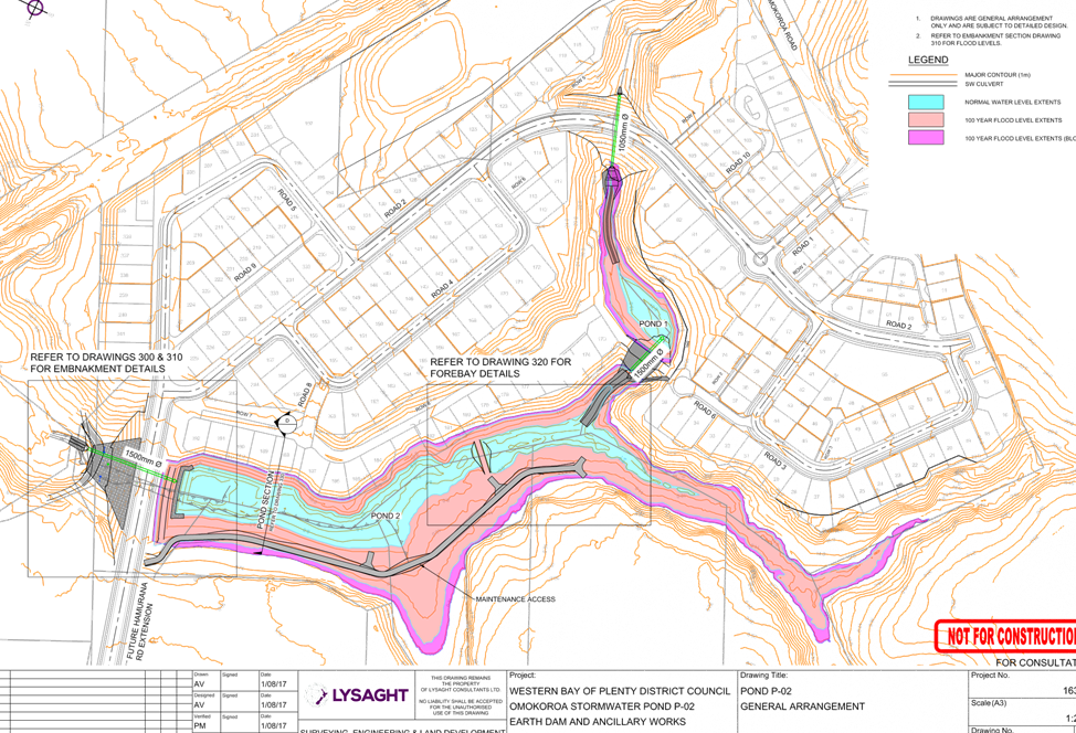
· Stormwater will be managed via reticulation and by maintaining the general contour for overland flow path. This will discharge to the gully system that drains towards the off site stormwater ponds recently established for the sub-catchment.
· Access to the proposed town centre will be via a new roundabout with Ōmokoroa Road and Flounder Ave. A through road is proposed to connect to the existing Sentinel Avenue in the Kaimai Views residential development.
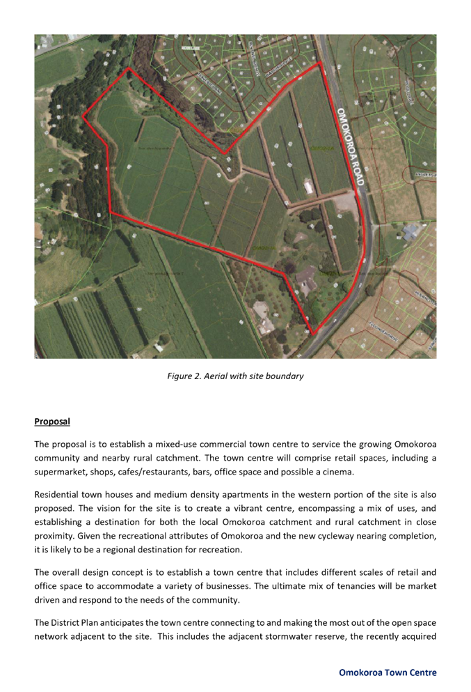
· Currently the site is utilised for a kiwifruit orchard and historically the site was utilised for farming (grazing) purposes with a large gully (now infilled) that crossed the property from the South East to the North West.
14. The site is included in the Ōmokoroa Stage 2 Structure Plan (Stage 2 Structure Plan), and is also part of the proposed Stage 3 Structure Plan currently under development by the Council.
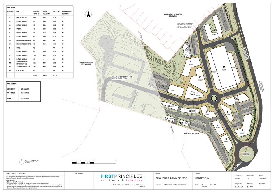
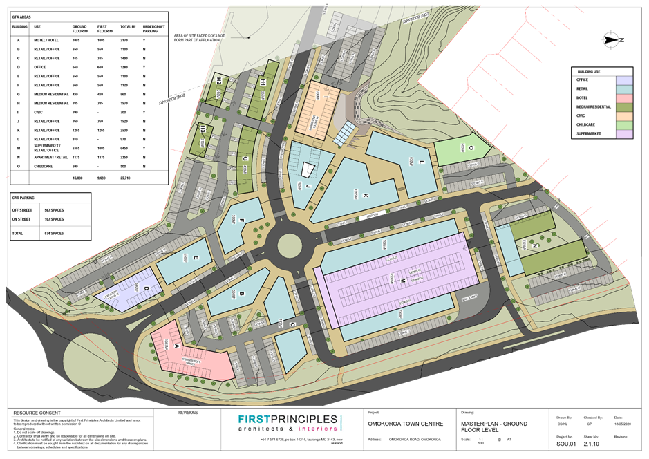
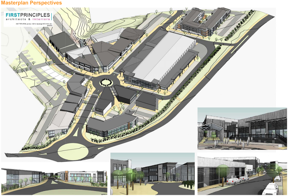
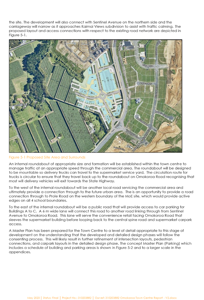
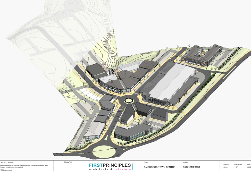
Masterplan
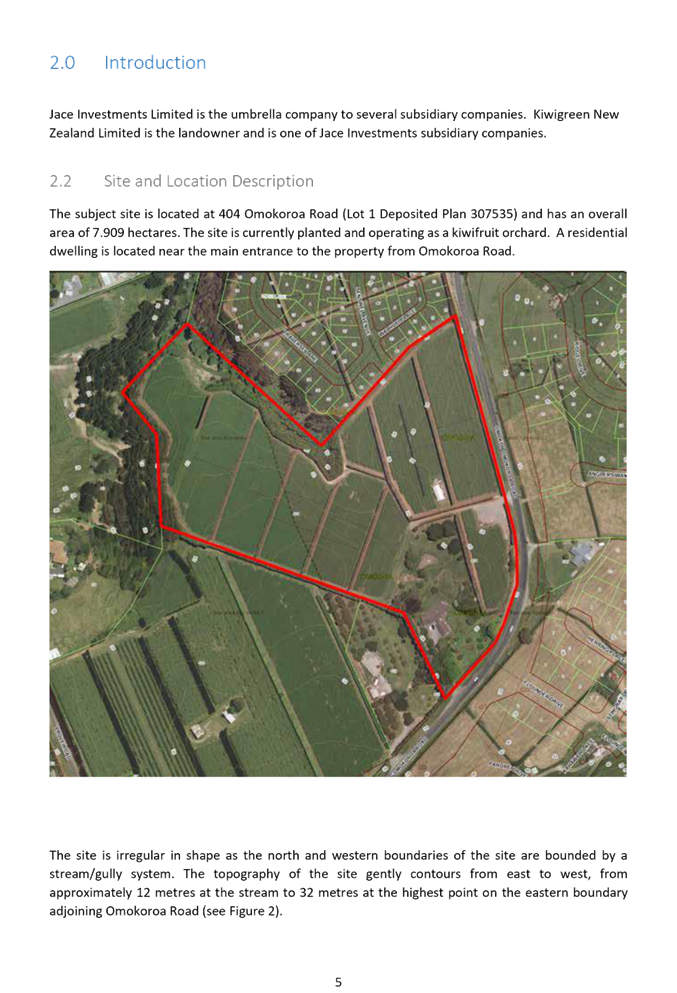
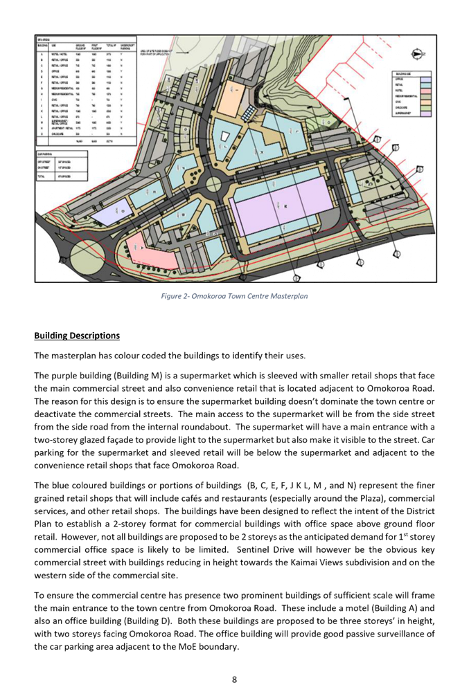
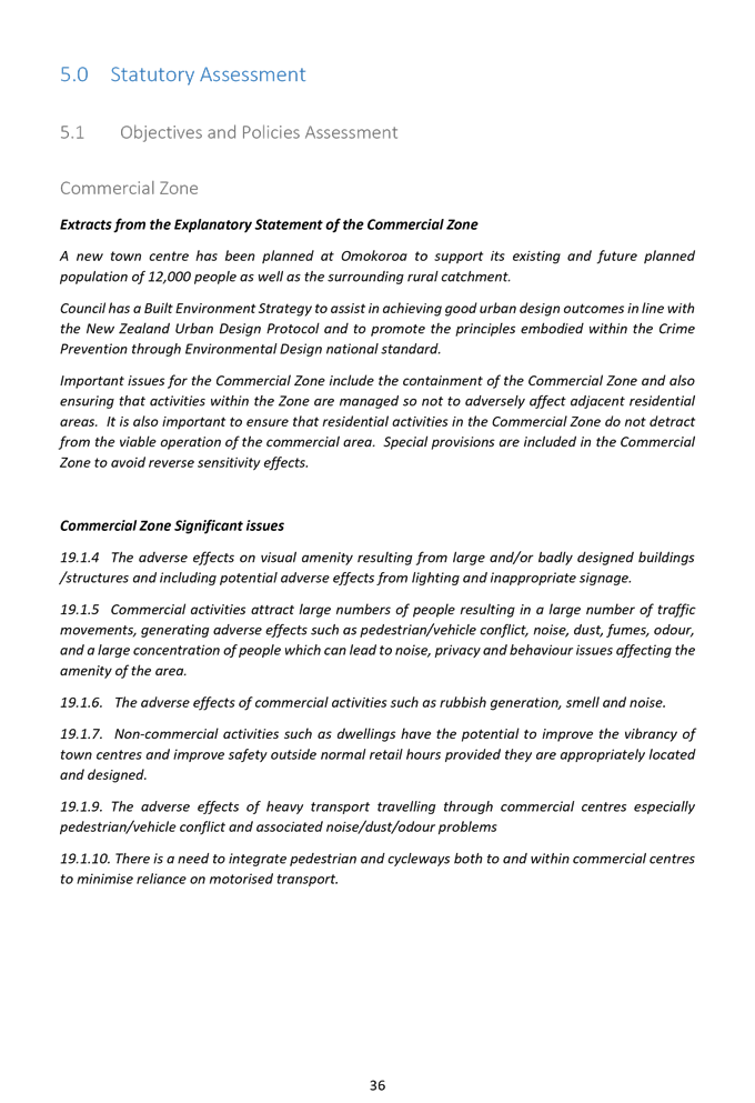
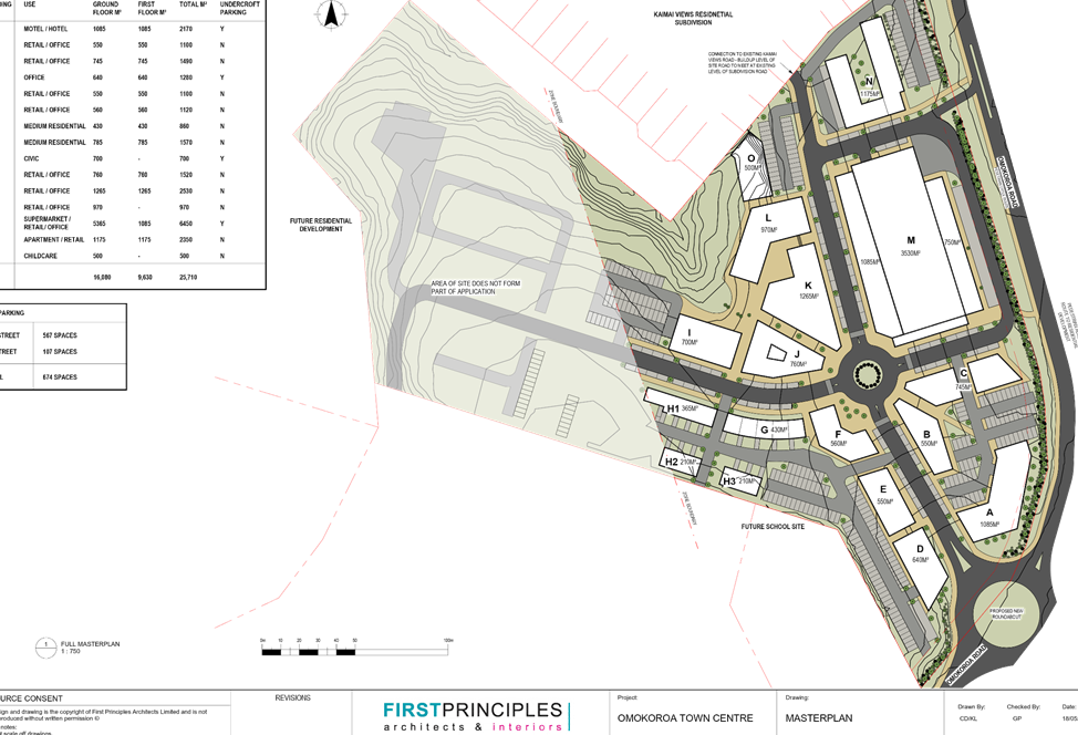
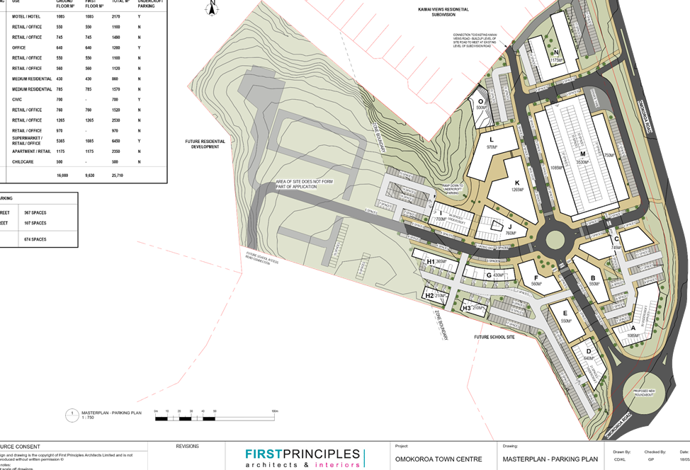
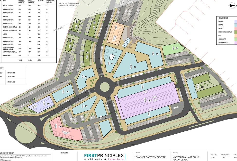
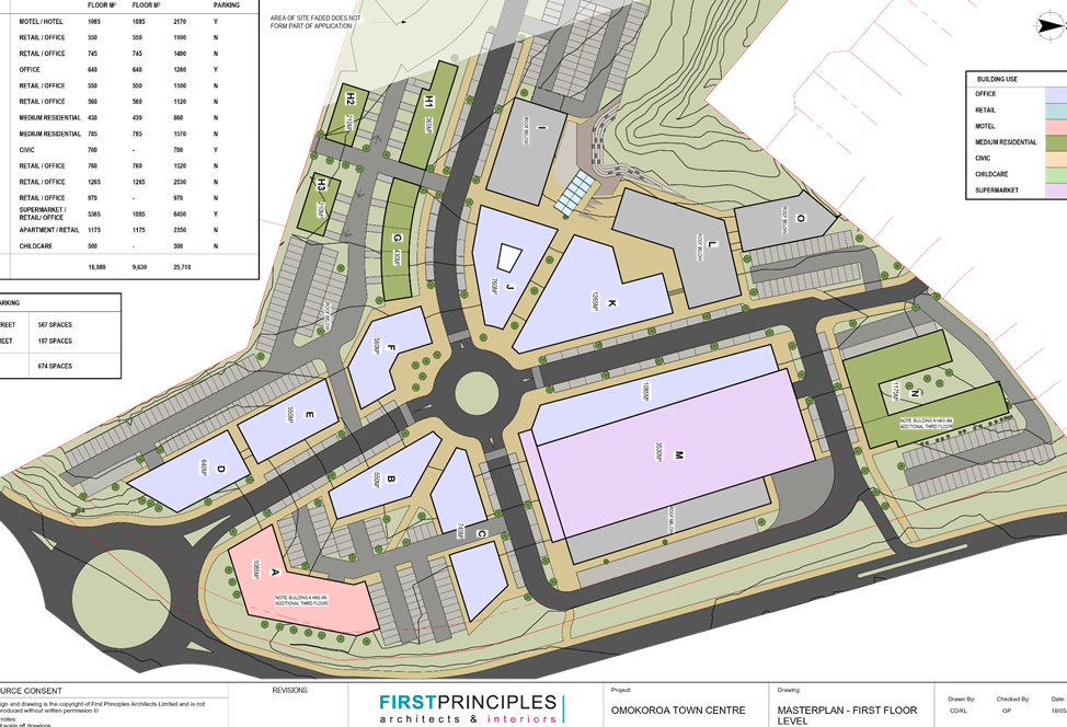
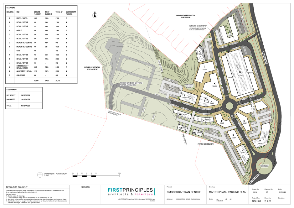
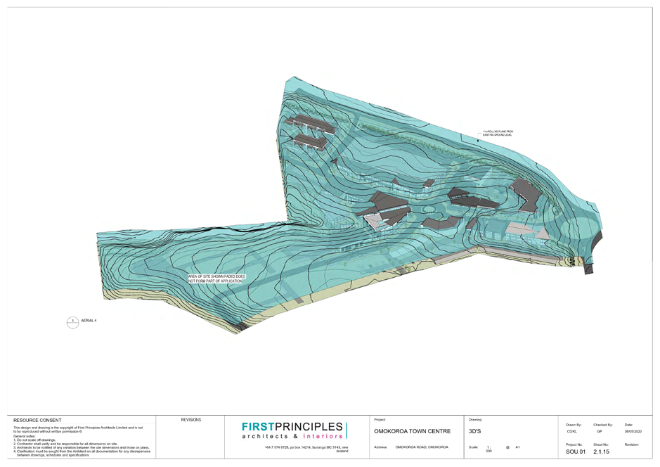
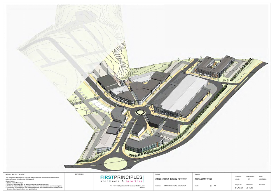
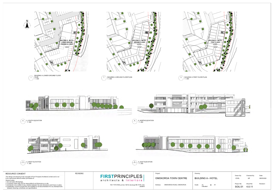
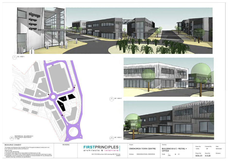
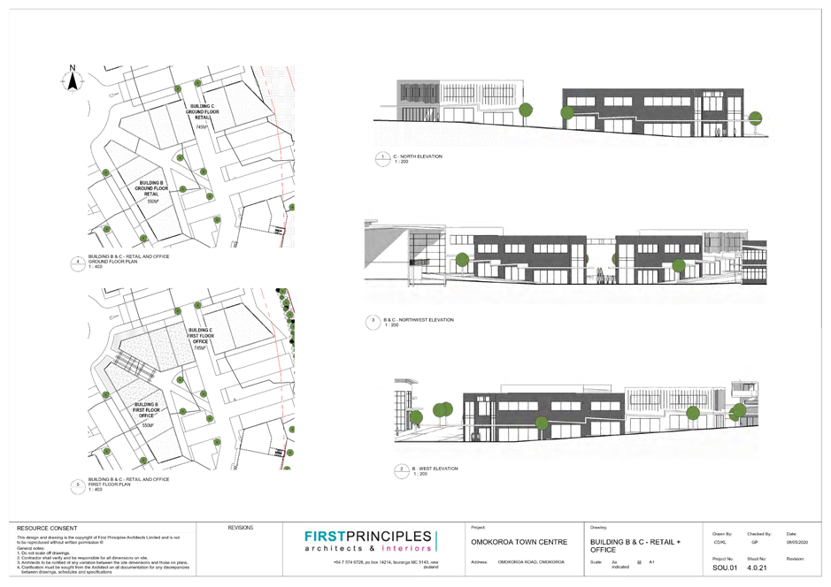
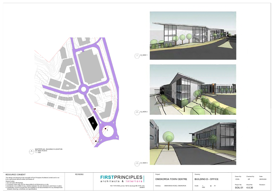
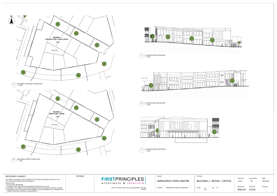
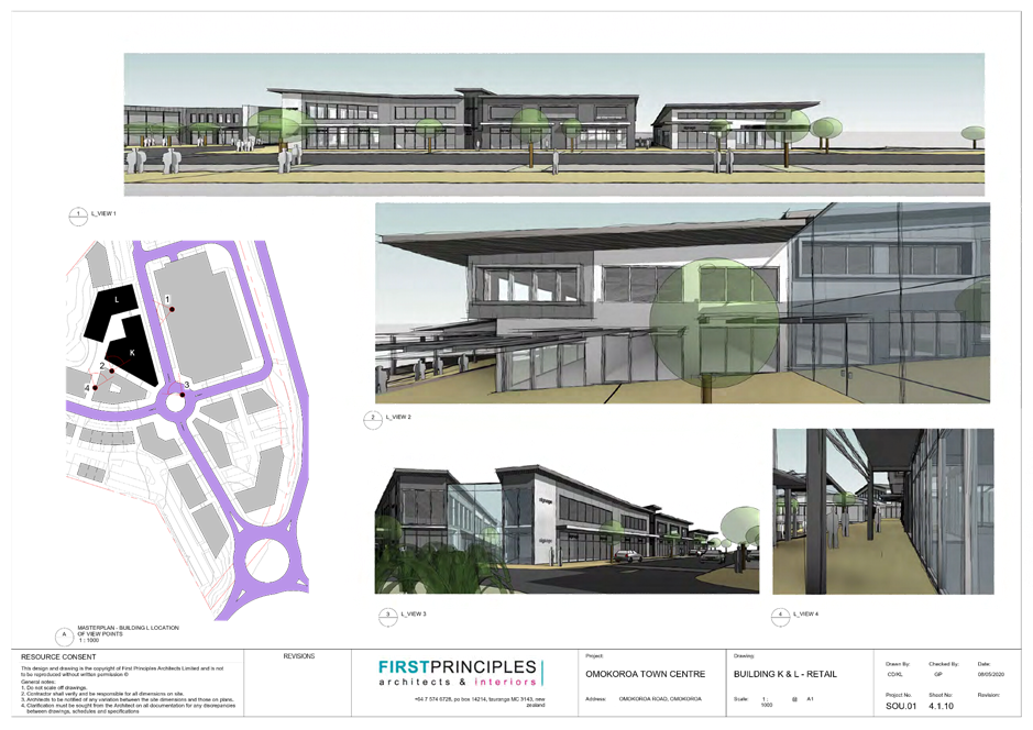
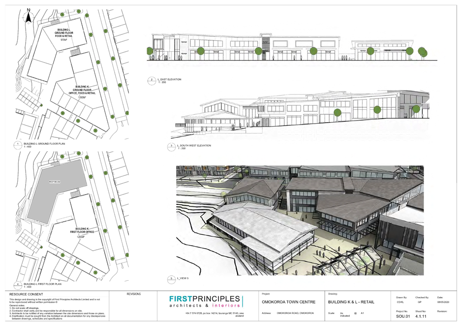
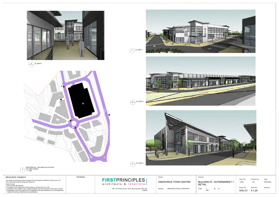
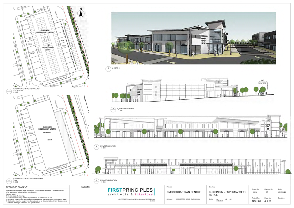
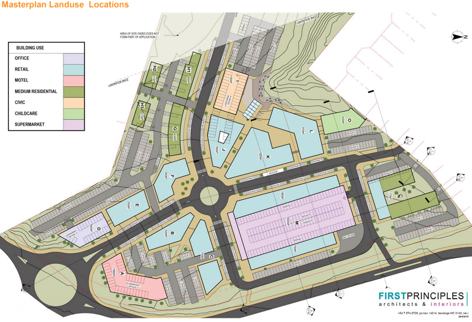
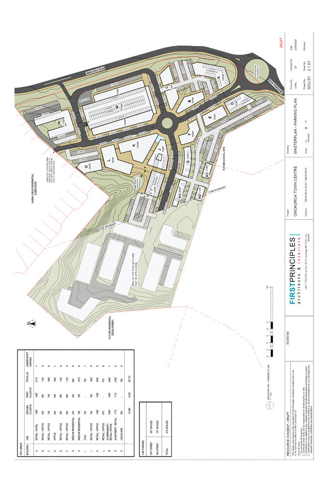
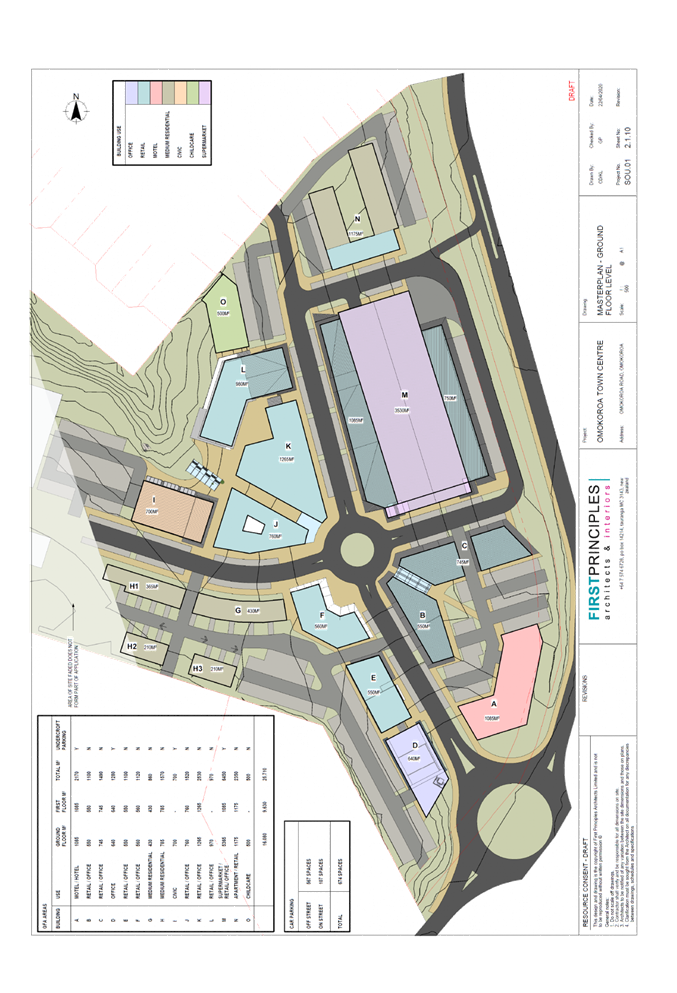
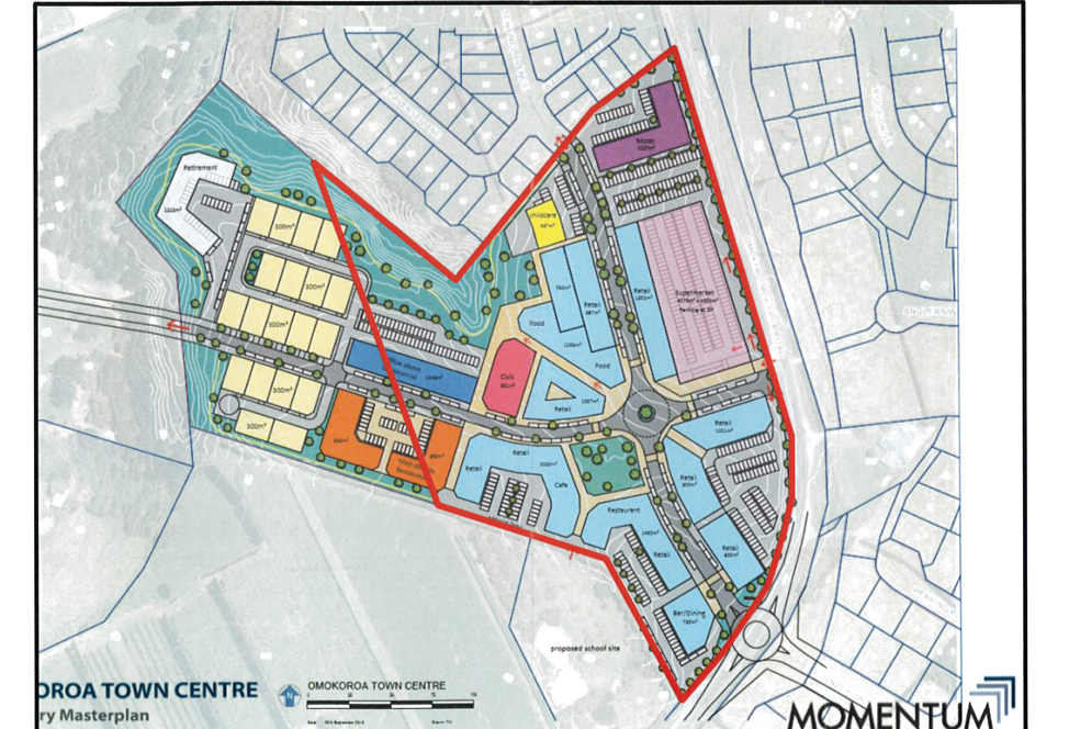
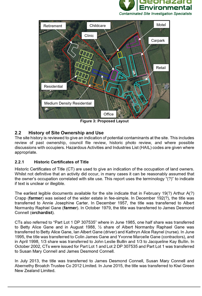
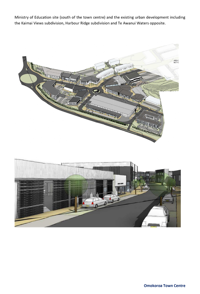
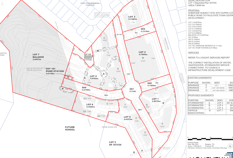
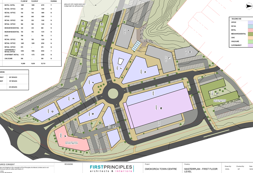
15. An overall Masterplan (Figure 1 below) has been developed for the proposed development which identifies the extent of the proposed Town Centre.
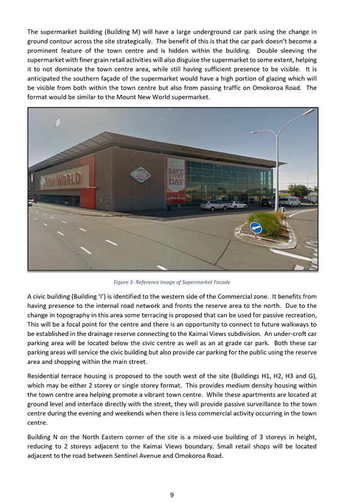
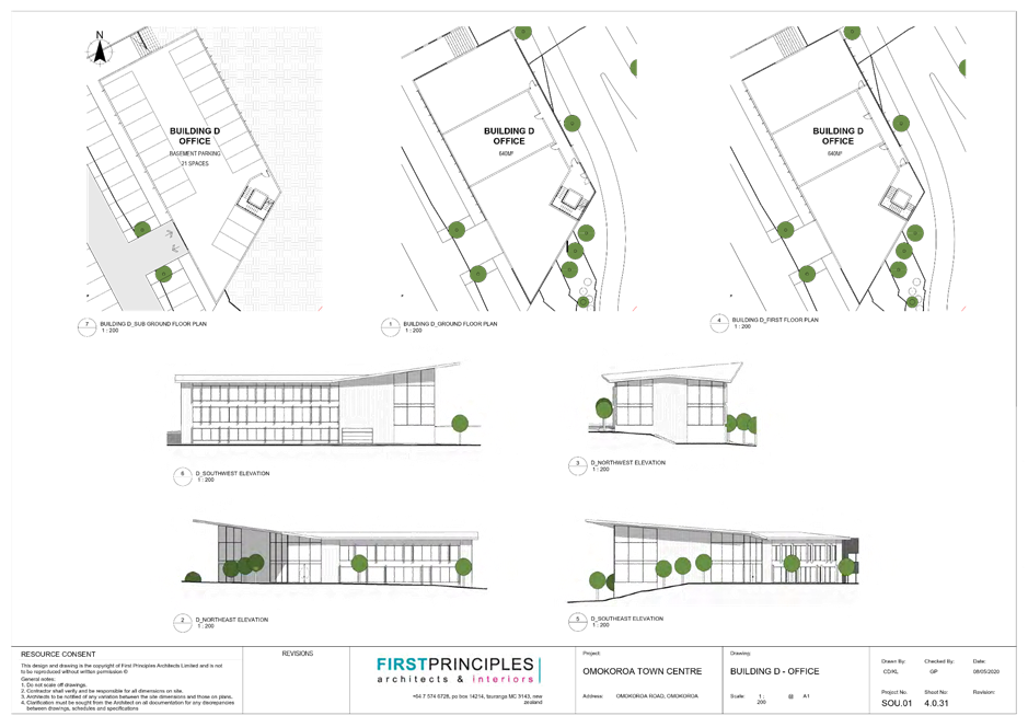
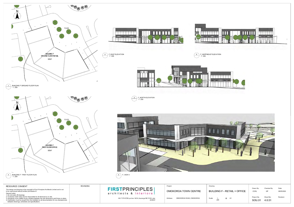
Building M Supermarket – sleeved by smaller retail and convenience retail adjacent to Ōmokoroa Road. The supermarket will have a large underground carpark
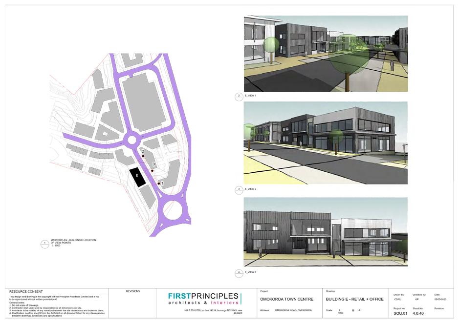
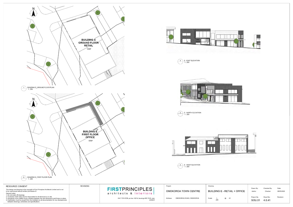
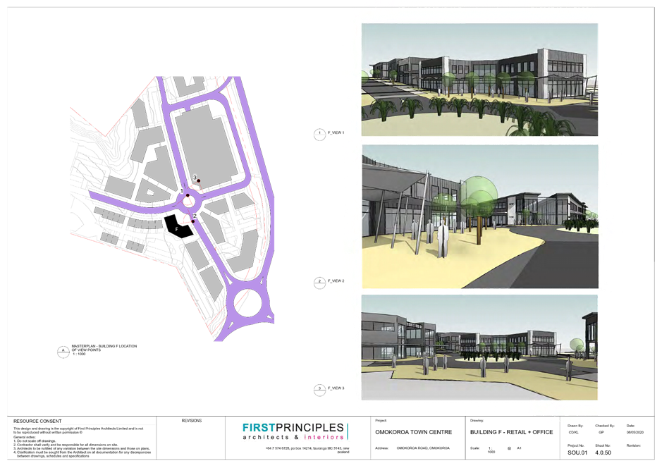
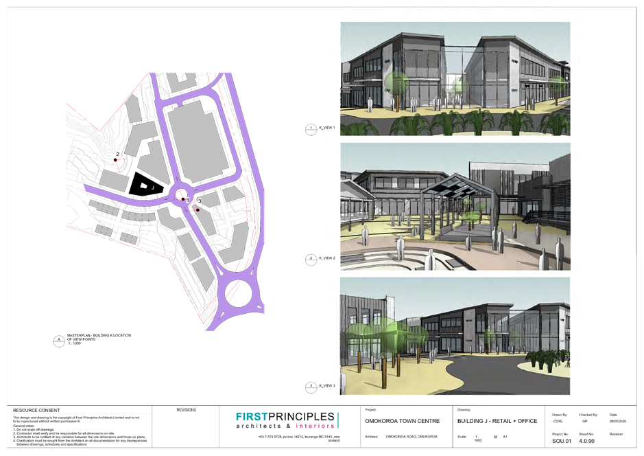
Buildings B, C, E, F, J, K, L, M & N Finer grained retail shops including cafes and restaurants, commercial services and other retail shops. These buildings are two storey format with office space above the ground floor retail.
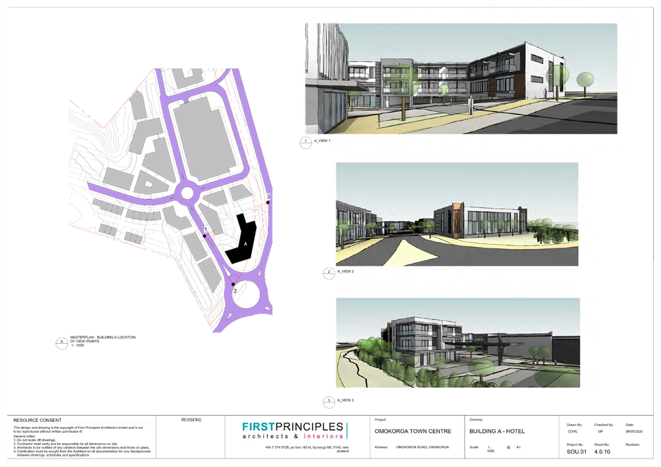
Buildings A & D Two prominent buildings of sufficient scale to frame the main entrance to the town centre from Ōmokoroa Road. Building A is a motel/hotel and building D is an office building. Both buildings are proposed to be 3 storeys in height.
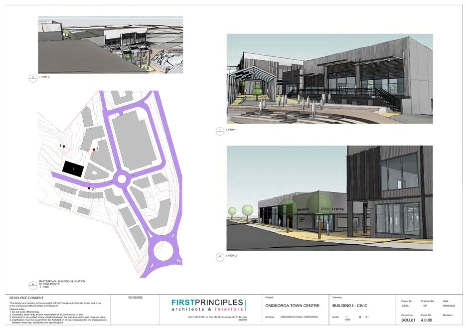
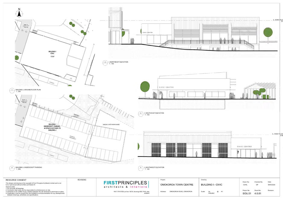
Building I Civic building
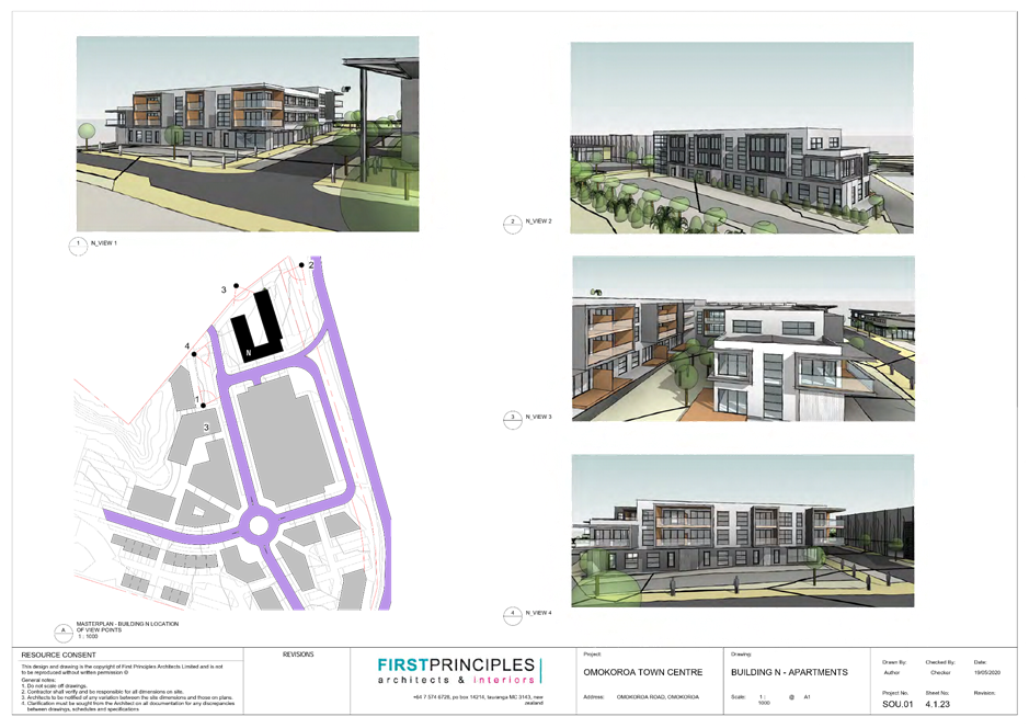
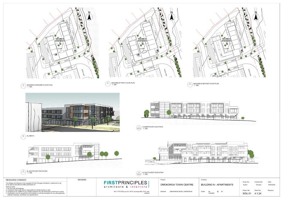
Building N Mixed use building of three storeys, reducing to two storeys adjacent to Kaimai Views. Small retail shops will be located on the ground level adjacent to Sentinel Avenue, with medium density apartments above.
![]() Building
O Childcare
centre
Building
O Childcare
centre
Figure 1: Overall Master Plan following s92 Request (also included at Attachment 5)
16. The proposal is outlined in the application details (Attachment 1) submitted as part of the application details including:
i) Assessment of Environmental Effects - Application Report, prepared by Momentum Planning and Design Ltd, entitled “Application for Resource Consent – Ōmokoroa Town Centre, 404 Ōmokoroa Road – For JACE Investments Limited”, dated 20 March 2020.
ii) Executive Summary
iii) Appendix 1 – Record of Title
iv) Appendix 2 – Ōmokoroa Town Centre Master Plan
v) Appendix 3 – Architectural Plans Full Set
vi) Appendix 4 – Urban Design Statement
vii) Appendix 5 – Urban Design Peer Review
viii) Appendix 6 – Services Report
ix) Appendix 7 – Transportation Assessment
x) Appendix 8 – Geotechnical Report
xi) Appendix 9 – Detailed Site Investigation - Revised
xii) Appendix 10 – Economic Report
xiii) Appendix 11 – Archaeological Report
xiv) Appendix 12 – Consultation with Utility Provider
xv) Appendix 13 – Iwi and Hapû Consultation Letters
xvi) Appendix 14 – Subdivision Scheme Plan
17. Seventy six (76) submissions were received during the submission period. 46 in support (4 conditional support), 19 oppose, 7 neutral, 2 conditional and 2 not specified. A summary and full list of submissions can be found at Attachment 4.
18. Following the close of submissions (17 July 2020), Council requested additional further information, refer Attachment 5. Peer Reviews of the Transportation Assessment, Landscape and Visual Assessment and the Urban Design Guidelines and Master Plan were also undertaken following the return of the further information.
19. In response to the further information requests from Council, the Applicant provided a response included as Attachment 6 made up of the following:
“Resource Consent RC11997L – Ōmokoroa Town Centre” dated 9 October 2020
· Attachment 1 – Masterplan and Architectural Plan Set
· Attachment 2 – Summary of Submission points
· Attachment 3 – Financial Contributions Assessment
· Attachment 4 – Subdivision Scheme Plan and Staging Plans
· Attachment 5 – Iwi Consultation
· Attachment 6 – Markets, precedents, Comparative Assessment
· Attachment 7 – Master Plan and Architectural Plan Set
· Attachment 8 – Ōmokoroa Town Centre Design Guidelines [pages
· Attachment 9 – Draft Conditions Land Use
· Attachment 10 – Landscape and Visual Assessment
· Attachment 11 – Existing Drainage Easements
· Attachment 12 – Lysaght – Earthworks and Cut to Fill Plan
· Attachment 13 – Lysaght – Retaining Wall Plans
· Attachment 14 – Geotechnical Report
· Attachment 15a – Stantec 200916 RFI Response
· Attachment 15b – Stantec 310203882_A5A-TR1
· Attachment 15c - Stantec 310203882_A5A-TR2
· Attachment 15d - Stantec 310203882_A5A-TR3
· Attachment 15e - Stantec 310203882_A5A-TR4
· Attachment 15f - Stantec 310203882_A5A-FIG 1A
· Attachment 15g - Stantec 310203882_A5A-FIG 6
· Attachment 15h - Stantec 310203882_A5A-FIG 7
· Attachment 16 – Concept Stage Road Safety Audit
· Attachment 17 – Lysaght – Road Layout Plan and Cross Sections
· Attachment 18a – Lysaght Wastewater Capacity Analysis – Present State
· Attachment 18b – LysaghtWastewater Capacity Analysis
· Attachment 19 – PowerCo and Fiber Consultation
· Attachment 20 – Acoustic Report
· Attachment 21 – Refuse and Loading Bay Location Plan
· Attachment 22 – Lysaght – General Services Arrangement Plan
· Attachment 23 – Lysaght – Erosion and Sediment Control Plan
20. The full application details are available on Council’s website along with the further information request from Council and the information received to support the application. During the submission period a full hard copy of the application was available at the Council’s The Centre – Patuki Manawa Katikati and the Ōmokoroa Library and Office.
SITE AND LOCALITY
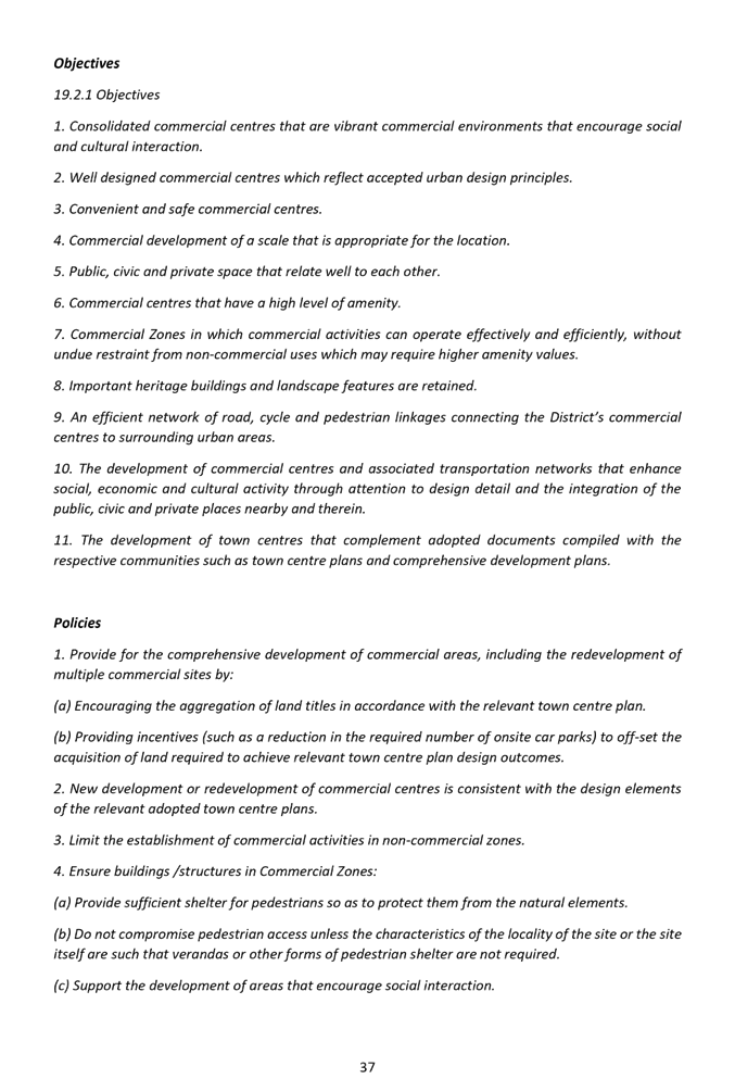
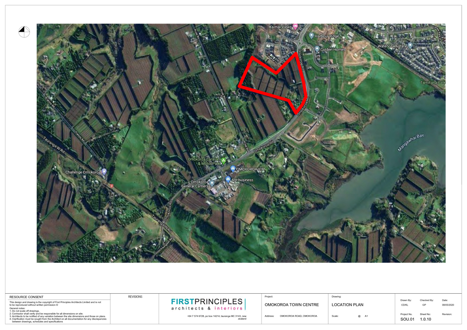
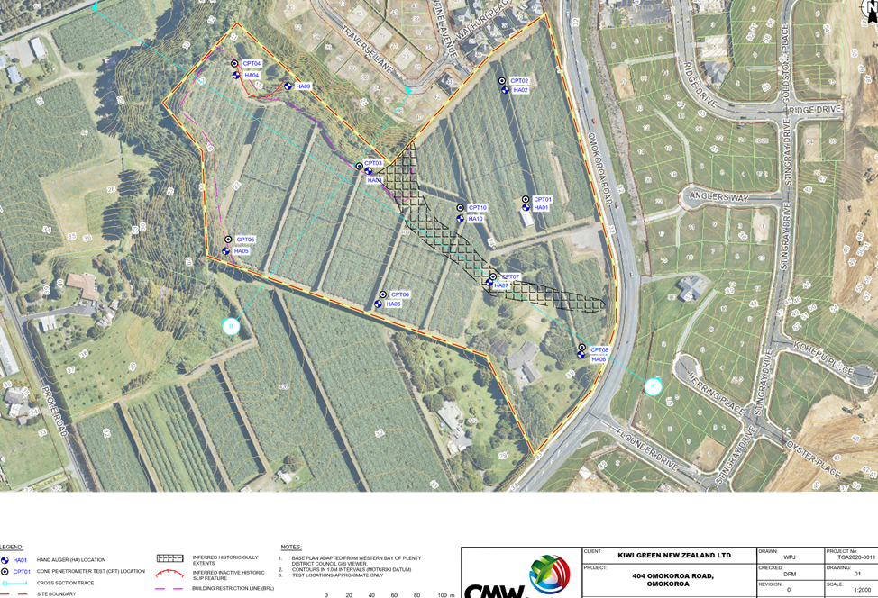
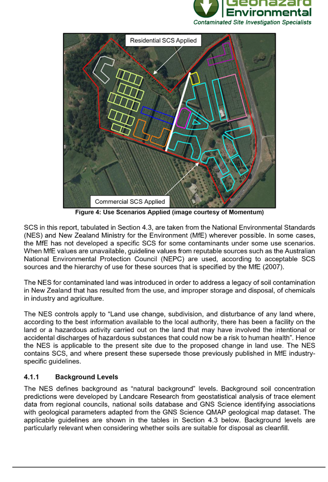
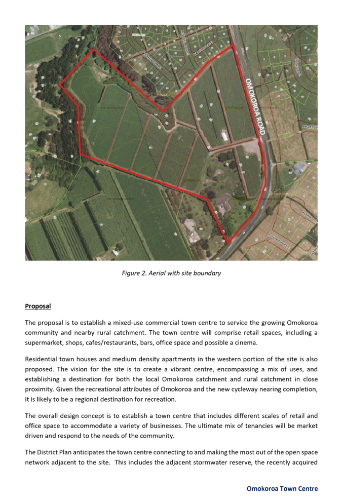
21. The application site is 7.9099ha and is an irregular shaped piece of land, with the site containing a split zone comprising of approximately 5.3ha of “Commercial” within the Ōmokoroa Stage 2-1A area and 2.6ha of “Future-Urban” (refer Appendix A of the application details for Record of Title included in Attachment 1). The site is subject to identified natural hazard layers which are currently not yet incorporated into the District Plan being Ōmokoroa Floodable Area and Liquefaction Ōmokoroa Stage 3 (damage unlikely). These layers are based on the most up to date hazard risk information and the Council relies on these layers when making decisions on resource and building consent applications and includes it in LIMs. Figure 2 below shows the current District Plan layers on the left and the non-District Plan Natural Hazard layers on the right. There are no recorded archaeological sites on the application site. The site contains designation D233, the requiring Authority being Western Bay of Plenty District Council (WBOPDC), for the purpose of Ōmokoroa Intersection Upgrades. There is also an Airport Approach Surface of 240m which crosses the western side of the site.
![]()
![]()
Figure 2: District Plan maps - Natural Hazards Liquefaction & Floodable
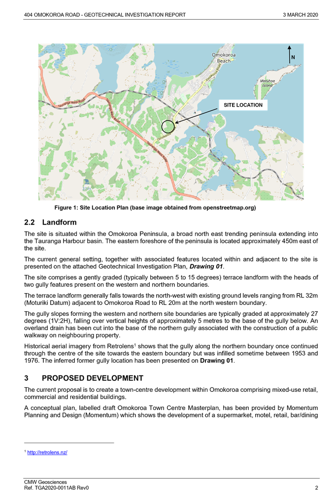
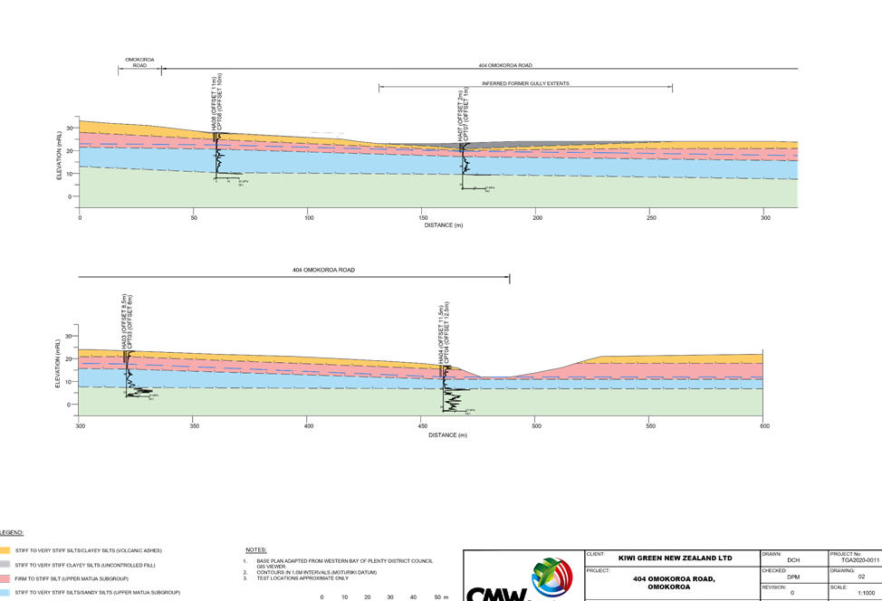
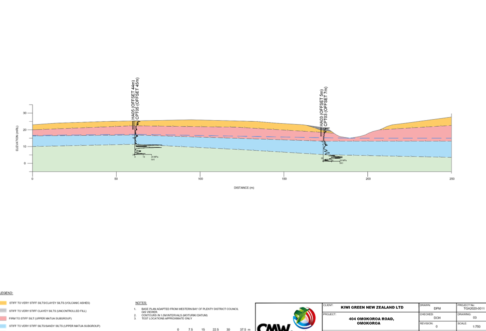
22. The site is currently a productive kiwifruit orchard and is bound to the east by Ōmokoroa Road, to the north by the Kaimai Views residential subdivision and kiwifruit orchards to the west and south. Figure 3 below shows the location of the property on the Ōmokoroa Peninsular. The Ministry for the Environment has also recently applied for and been granted a Notice of Requirement for a new school on the adjoining property to the south at 426 Ōmokoroa Road. There is a single dwelling located in the south eastern corner of the property and an existing barn located centrally on the site. The site comprises a gently graded terrace landform with the heads of two gully features present on the western and northern boundaries. The terraced landform generally falls towards the north-west with existing ground levels ranging from RL 32m (Moturiki Datum) adjacent to Ōmokoroa Road to RL 20m at the north western boundary. The gully slopes forming the western and northern site boundaries are typically falling 5m to the base of the gully below. The northern gully continues north into the neighbouring property. Historical aerial imagery from the Retrolens website identifies that the gully along the northern boundary once continued through the centre of the site towards the eastern boundary but was infilled sometime between 1953 and 1976 in conjunction with development of the orchard on site.
23. Activities within the immediate and wider environment include predominantly orchard activities, small scale farming and residential activity, reflective of the underlying zonings. With the principal character of the immediate surrounding environment being orchard activities to the west and south of the application site and residential activity to the north and east.
24. The wider environment is currently going through a process of change, with residential development occurring on the commercially zoned land directly to the north, adjoining the site, as part of the HASHA and Special Housing Area legislation. To the south and west there are areas involved in the proposed Stage 3 Structure Plan process which will open up land for future residential development. Urban road upgrades are also underway for Ōmokoroa Road and Prole Road with physical works expected to commence in 2021.
25. ![]() The
site adjoins an area to the north which is currently zoned
“commercial” however it has been developed as a residential subdivision
(Kaimai Views) under the Housing Accords and Special Housing Areas Act 2013
(HASHAA) as a Special Housing Area (SHA). Council has not yet undergone the
necessary plan change to rezone this land to residential, and the zoning was to
be considered under Ōmokoroa Stage 3 Structure Plan.
The
site adjoins an area to the north which is currently zoned
“commercial” however it has been developed as a residential subdivision
(Kaimai Views) under the Housing Accords and Special Housing Areas Act 2013
(HASHAA) as a Special Housing Area (SHA). Council has not yet undergone the
necessary plan change to rezone this land to residential, and the zoning was to
be considered under Ōmokoroa Stage 3 Structure Plan.
Figure 3: Site Location
Site Context and Planning Timeline
26. The Stage 1 Structure Plan (PC 20) was made operative in 2004 and urbanised the area between Ōmokoroa Country Estate and the East Coast Main Trunk Railway line, in anticipation of wastewater reticulation being available. In 2007 wastewater was reticulated on the peninsula.
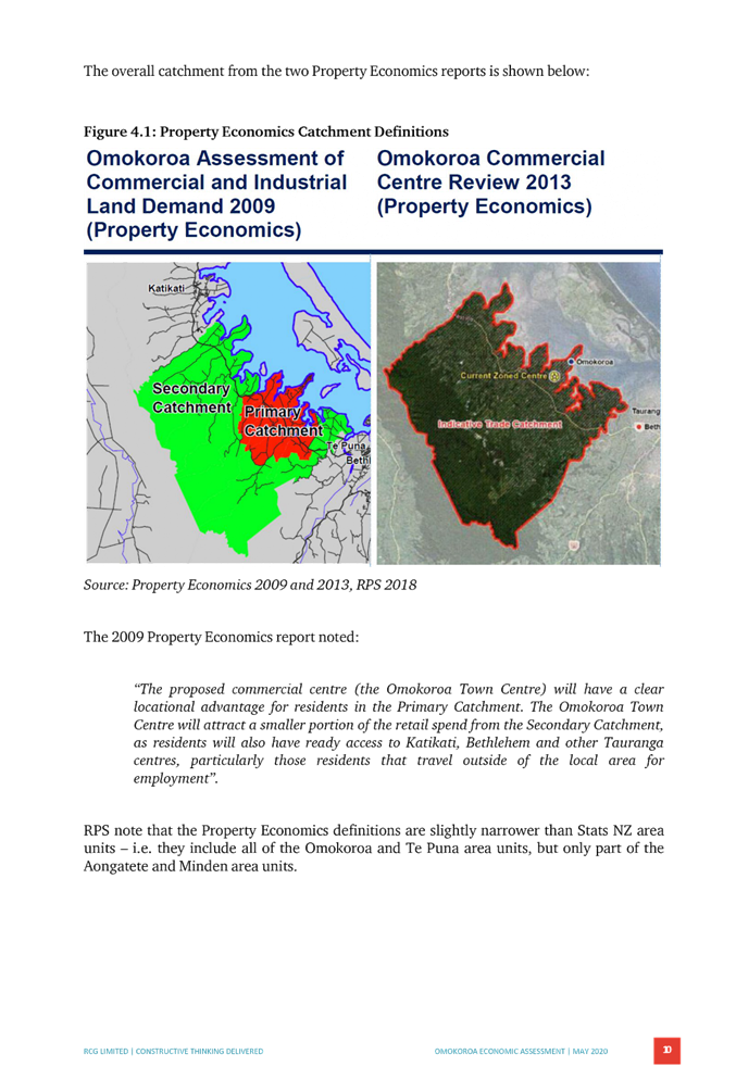
27. In 2009 Property Economics were engaged by Council to prepare an assessment of market potential for a town centre at Ōmokoroa. The Report determined an ultimate demand for a town centre of 11-12ha.
28. In 2009 Council undertook Plan Change 69 - Stage 2 Structure Plan which:
i) Reviewed the District Plan rules for Stage 1
ii) Extended the urban area to include the developments south of the East Coast Main Trunk Railway line and to the east of Ōmokoroa Road, now known as Harbour Ridge, Te Awanui Waters, and to the west of Ōmokoroa Road being industrial and commercial zoned land now known as Kaimai Views and the JACE property. Approximately 12ha was zoned Commercial for the town centre as part of this Plan Change.
iii) As part of Plan Change 69 the Stage 2 Structure Plan was prepared for the whole of the area from SH2 to the East Coast Main Trunk Railway line, but the component related to the Future Urban Zone was withdrawn through the Environment Court Appeal process.
iv) The Stage 2 Structure Plan S32 Report prepared by BECA (August 2007) estimated a town centre of 13ha. Their calculations were based on evidence by Akehurst of Market Economics prepared for the Tauranga City Pyes Pa West Hearing.
v) The particular location for the commercial and civic area was selected based on it being “close to the railway line, because it is centrally located within the peninsula, with excellent visibility and access for vehicles. Its proximity to the railway provides the best opportunity for public transport use in the future.”
vi) The Stage 2 Structure Plan S32 report detailed several points associated with the consenting process including:
· Restricted discretionary activity status for comprehensive development subject to urban design standards and criteria, a comprehensive development plan for whole zone, provision of retail and other permitted activities and integrated car parking provision.
· A Comprehensive Master Plan to be undertaken which will ensure Council is clear on how the entire zone will function and integrate with adjoining land uses.
· Commercial Structure Plan to be notified, however there were no details on how or under what process.
29. Following from Plan Change 69 for the Stage 2 Structure Plan Council held discussions with a number of developers, including Progressive Enterprises and Foodstuffs, to initiate the development of the town centre. The developers present considered that the proposed town centre/ commercial zone was not at the right location due to:
i) the slope of the land,
ii) no visibility from State Highway 2,
iii) upfront costs and
iv) the size of the catchment.
30. They considered that the future town centre should be as close as possible to the Ōmokoroa Road/State Highway 2 intersection because that location will:
i) increase the size of the catchment which will have a significant impact on the timeframe,
ii) be more visible from State Highway 2, and
iii) be close to the future industrial area (employment area)
31. In August 2013 the Property Economics Report was prepared for Foodstuffs by Veros. That report made the following conclusions in relation to the future town centre:
· requirement for 2ha plus roading (excludes civic/community)
· a town centre located adjoining SH2 will be larger and more successful than a centre in the current zoned location. This would provide increased benefits for the local Ōmokoroa community beyond those that could be achieved by a centre in the current zoned areas.
32. In August 2014 the Housing Accord was signed to allow development of Kaimai Views residential subdivision. This resource consent was granted in January 2017 and development is well underway at stages 3 & 4.
33. In November 2017 public open days were undertaken to commence the Stage 3 Structure Plan. This included seeking feedback on the preferred location for a town centre. The town centre options were presented as: the JACE site (option 1), and between the State Highway and Prole Road (options 2 & 3) as shown on the map below (Figure 4).
34. As part of the feedback received from the community, Council received a submission from Veros Property Services on behalf of Foodstuffs North Island Limited. The letter stated Foodstuffs had previously purchased a property at 492 Ōmokoroa Road, which is located within option 3. As a key anchor tenant in any development, it was their professional opinion, that this was the best location for a connected and integrated town centre.
![]()
Figure 4: The 2017 Town Centre Location Options
35. In March 2018 RPS Group (RPS) undertook an Economic Review as part of the Stage 3 Structure Plan process. The Report can be read in full at Attachment 8, however can be summarised below:
· 3.5ha needed for a commercial town centre excluding roads, open space and community uses.
· Further development of the Tralee Street centre will likely delay the timing and scale of the planned town centre.
· Location for a commercial zone is preferred nearest the State Highway. This will maximise the patronage from the secondary trade area. Reduced patronage from the secondary trade area and passing traffic may decrease the planned scale of the town centre and/or delay the timing of any development.
36. In September 2018 the second round of public open days for Stage 3 Structure Plan were undertaken. Taking into account the feedback received following the first round of consultation four structure plan layouts were consulted on between the State Highway and Francis Road realignment, or between Francis Road realignment and Prole Road.
![]()
Figure 5: Location of preferred option at 29 November 2018 Policy Committee Workshop
37. Direction was given by Council at a 29 November 2018 Policy Committee Workshop that the preferred option was Option 2, shown on Figure 5 above, following a technical workshop on 28 November 2018 with key staff and stakeholders.
38. In September and November 2019 JACE representatives met with Council’s Chief Executive Officer and other senior staff to introduce themselves and discuss their proposal.
39. In November 2019 town centre perspectives were prepared by RPS for Council (for community engagement) showing what a town centre might look like at the preferred option 3 location.
40. In February 2020 Council’s Resource Management Manager Mr Phillip Martelli arranged a conference call with JACE technical representatives and Council’s advisor RPS following the applicants meeting with the CEO. Points raised were:
· Location further away from State highway than other options.
· Geotechnical and contour constraints.
· Interface with recently secured school site could be improved.
· Quantum of commercial gross floor area likely to be more than needed for catchments.
· Potential traffic effects.
· Interface with gully systems needs improvement.
41. A follow up email was provided from Council that set out the criteria and performance standards for the Commercial Area Master Plan in the District Plan section 19.5, and commentary as to how the JACE proposal addressed them.
42. In May and June 2020 the third round of community engagement was scheduled to occur:
· Consultation letters posted to landowners on 20 May 2020 advising of public open days on 3 June.
· JACE application lodged on 21 May 2020.
· Postponement letters posted to landowners on 27 May 2020.
43. In July 2020 RPS completed an update to their 2018 Economic Report “Ōmokoroa Town Centre Demand Assessment and Alternative Site Evaluation” as part of the Stage 3 Structure Plan process which re-evaluated the possible town centre locations. The conclusion of this report was that site 2 (Figure 6 below) on the corner of Prole Road and Ōmokoroa Road was the preferred location for the Ōmokoroa Town Centre.
44. Following receipt of this application in May 2020, the Stage 3 Structure Plan process was placed on hold pending outcome of this resource consent application.
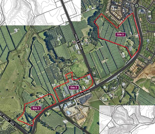
Figure 6: Map showing location of RPS July 2020 preferred option 2.
NOTIFICATIONS AND SUBMISSIONS
Notification
45. The applicant, JACE Investments Limited, lodged a combined land use and subdivision resource on 21 May 2020 and requested public notification under Section 95A RMA.
46. A copy of the public notice is included as Attachment 2. Notice was served on identified affected persons including those on Council’s statutory list on 19 June 2020 via email and Council’s website. The public notice was included in the Bay of Plenty Times, New Zealand Herald and the Ōmokoroa Lizard, a local community publication.
Submissions received
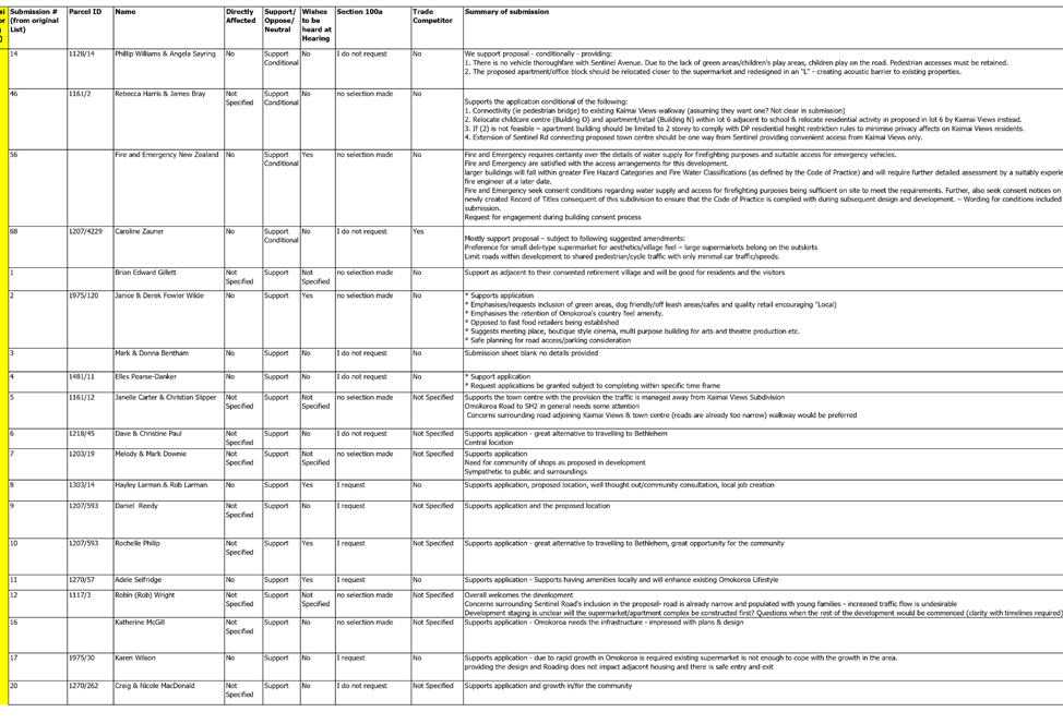
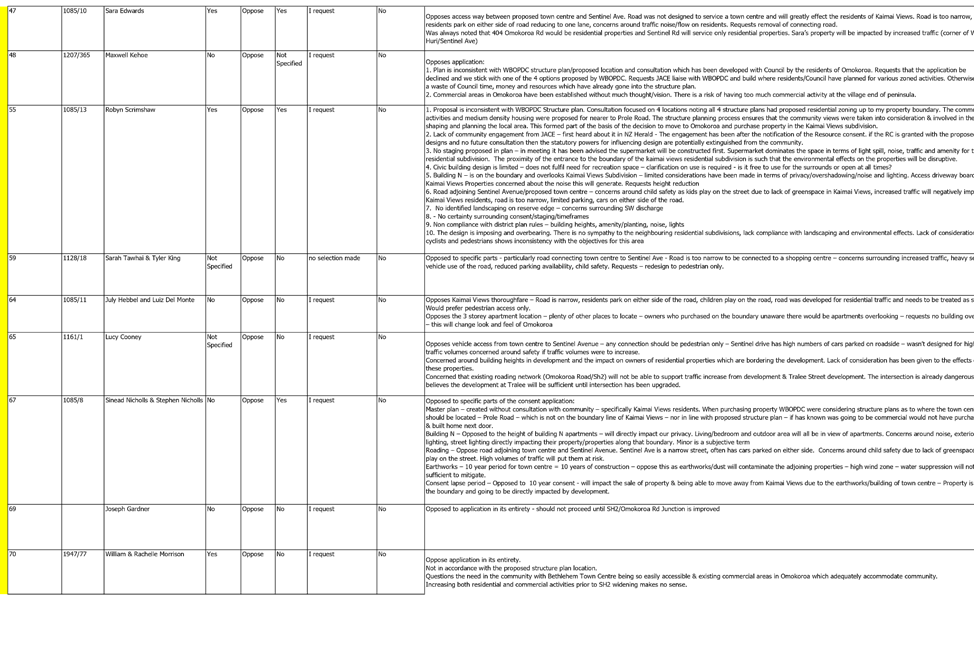
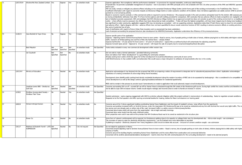
47. The period for making submissions on the application closed on 17 July 2020. In total 76 submissions were received within the statutory time period (20 working days), 46 submissions in support (4 conditional support), 7 neutral and 19 submissions in opposition, with 2 conditional and 2 not specified. 23 submitters indicated a wish to be heard.
48. Maps showing the submitters in relation to the application site is included in Attachment 4, and Figure 7 below. It should be noted that a number of submissions were received from submitters residing outside of Ōmokoroa, in the surrounding rural areas, Te Puna and Minden. 10 of the 76 submissions were received from larger groups including the Bay of Plenty Regional Council, PowerCo, Pirirākau Incorporated Society, Fire and Emergency NZ, Ōmokoroa Gold Club, Ōmokoroa Ratepayers Association, Ministry of Education, Classics Group, Woolworths NZ Limited and Ōmokoroa Public Art Group.
![]()
Figure 7: Submissions received (in immediate vicinity of application site)
Matters raised
49. A summary of all submissions received is included as Attachment 4, including a submitter location map. Further, summaries of the key issues raised by submissions are outlined below under topic headings.
Environmental / Sustainability
50. Of the 76 submissions received, 3 submissions included matters related to the environment and sustainability. There was 1 submission in support and 2 opposing.
51. The one submission in support stated the environmental considerations were clear.
52. The common themes in comments for those in opposition were concerns surrounding the sustainable building/ environmental design, lack of reference to low impact urban design, alternative modes of transport, low impact stormwater design, not consistent with objectives and policies, reduction of car dominance, not a sustainable management of resources, not in accordance with RMA principles and not consistent with Part 2 and other provisions of the RMA and District Plan.
Regional Development / Economic
53. Of the 76 submissions received there were 6 with comments surrounding regional development and economic factors, 5 of which were in support and 1 opposed.
54. Overall there is a similar theme in submission comments from the supporters surrounding provisions for regional and economic development, the potential growth benefits, and the potential for the creation of job opportunities. Most supporters expressed general support but did not provide detailed comments.
55. Overall the submissions in opposition consider potential adverse effects on the consented Ōmokoroa Village Centre/ Fresh choice, size of proposed commercial centre and cumulative commercial need for the area, lack of detailed economic assessment for the site, lack of assessment to alternative town centre locations, lack of assessment on function of existing commercial areas and adverse economic effects.
Amenity / Character / Housing / Community
56. Of the 76 submissions received there were 34 submissions who made comments surrounding amenity, character, housing and community. There were 21 submissions in support and conditional support and 18 opposed.
57. Common themes in support of the application included that it:
· provides green space,
· encouraged quality retail and cafes,
· was sympathetic to surroundings,
· provided an alternative to travelling to Bethlehem,
· lessened vehicles travelling to Tauranga,
· supports family lifestyle,
· provides community areas,
· was central to the residential population,
· would make Ōmokoroa self sufficient,
· provides onsite amenity for higher density living.
58. Common themes of those in opposition to the proposal included:
· poor urban design,
· lacks innovation,
· lack of consideration of local context and sustainability considerations,
· lack of building design and character,
· proposed office building creates inactive street front at entrance,
· poor activation of open public space areas including plaza area,
· lack of, and poorly located, liveable public spaces,
· location of three storey apartment building overlooking residential area,
· privacy, scale and amenity effects,
· bulk and scale of buildings will change the look and feel of Ōmokoroa,
· lack of consideration for the need to integrate with Kaimai Views properties,
· noise and lighting effects on adjoining properties,
· concerns that the development will be piecemeal/standalone,
· lack of details on how the development is fits with community/plans for the surrounding area,
· location of childcare centre inappropriate,
· lack of detail on design outcomes and landscaping,
· lack of human scale approach and buildings dominating views,
· further information requested on CPTED and underground carpark,
· existing commercial area has space for development,
· no identified children’s play areas,
· poor location of Civic Building on edge of town centre,
· requests for buildings to have a ‘village feel’,
· lack of consideration for pedestrians and cyclists,
· lack of community engagement during the design process to achieve desired outcomes for the community.
Roading / Infrastructure / Stormwater / Water
59. Of the 76 submissions received, 36 submissions made comments surrounding roading and infrastructure, of which 26 were opposed and 10 in support.
60. One submitter supports the potential for improved infrastructure for the broader Ōmokoroa community. However, many (including overall supporters of the application) have concerns around suitable roading, parking, the impact on traffic levels, and traffic effects onto Sentinal Avenue and through Kaimai Views. Some also support the potential reduction in traffic on SH2 to Tauranga and the left turn out only at the northern exit.
61. Those in opposition all had similar concerns in relation to transportation effects and in particular:
· the road connection to Sentinal Avenue and through Kaimai Views,
· the potential for increased through traffic via an under width residential road,
· child safety,
· whether thoroughfare through to Kaimai Views should be pedestrian only (or one-way access only),
· the design of Sentinal Avenue and whether it is suitable for future residential use on the adjoining property.
62. Other concerns and requests include:
· continued dominance of vehicles within the town centre,
· more provision for pedestrian and cycleways,
· pedestrian only main street,
· additional traffic calming measures,
· safe pedestrian/cycle access from eastern side of Ōmokoroa Road,
· unsafe conflict between commercial vehicles, passenger vehicle, pedestrians & cyclists,
· concerns around existing roading network and Ōmokoroa Road/SH2 intersection being unsafe,
· SH2 safety improvements should be undertaken prior to allowing any further development.
63. With regard to stormwater matters, some submitters are concerned about on site stormwater management and options for rain gardens/ swales, lack of provision for stormwater collection for large impervious surface, increase in stormwater additional to that from Kaimai Views.
64. With regard to water supply, Fire and Emergency New Zealand requires certainty over the details of water supply for firefighting purposes and suitable access for emergency vehicles.
Cultural
65. Of the 76 submissions received there were 2 submissions with comments surrounding cultural factors, of which both were in support. In general submitters noted the importance of hapū involvement, and ongoing engagement with Pirirakau.
Structure Plan
66. Of the 76 submissions received, 10 submissions made comments surrounding the Ōmokoroa Structure Plan matters, of which 1 submission was neutral and 9 were opposed.
67. The neutral submission (which supported the application overall) seeks clarification on whether the proposal conforms to the overall planning scheme for Ōmokoroa.
68. Submitters in opposition again held the following concerns:
· that the application is premature and inconsistent with the Council‘s structure planning process,
· how the application would create an integrated design with the Structure Plan,
· the proposed Town Centre site should be at the corner of Prole Road,
· lack of consultation between the applicant and the community,
· Council‘s structure plan process indicated the site would be residential use,
· that JACE liaise with Council over the proposed Stage 3 Structure Plan otherwise it might result in an inefficient use of Council resources and risk of having too much commercial land in Ōmokoroa,
· community views have been considered in the Council’s structure plan process and planning for / development of the local area,
· the applicant has created Masterplan without consulting with the community first,
lack of analysis surrounding the proposed Stage 3 Structure Plan which undermines the efficiency of this process/outcome.
Miscellaneous
69. Finally, there were 11 of the 76 submissions which could not be grouped under the preceding topics. Out of the 11, 5 submissions were in support, 2 were neutral and 4 opposed.
70. Those in support of the proposal requested the application be granted subject to specific timeframes/ lapse date, considers it an alternative to traveling to Bethlehem, requested clarification on staging
71. Those who were neutral requested continued involvement in the application process, requested conditions regarding water supply and access and involvement during the building consent process
72. Submitters in opposition considered the application to be contrary to many objectives and policies of the District Plan, question the need for additional commercial land, identify non-compliance with the commercial zone performance standards, believe there to be a lack of clarification with regards to Future Urban Zone.
PLANNING FRAMEWORK AND ACTIVITY STATUS
73. The notification date of the Operative District Plan 2012 was 18 June 2012 and all appeals have been resolved. Council has notified a number of plan changes since this time with all but one now being operative. The remaining plan change which is yet to be operative is Plan Change 81 which concerns the Ōmokoroa Industrial Zone and has no relevance to this application.
Activity Status - Operative District Plan 2012
74. Under Rule 19.3.3(b) of the Operative District Plan 2012 within the Commercial Zone shown on the Ōmokoroa Stage 2 Structure Plan all activities other than a dwelling shall be a Restricted Discretionary Activity subject to the development of a commercial area master plan and activity performance standards listed in 19.5. Council has not yet prepared a master plan for the commercial area. Further, the proposal does not meet a number of the activity performance standards listed in 19.5. The proposed activity within the Stage 2 Structure Plan commercial zone is otherwise not specifically provided for as a discretionary or non-complying activity under the commercial zone rules. Accordingly, the activity defaults to Rule 4A.1.4 of the District Plan, and non-complying activity consent is required.
75. Under Rule 12.4.4.4(b) of the Operative District Plan access on to Ōmokoroa Road – the number or potential number of dwellings or other activities gaining direct access to these roads shall not be increased, with a minimum separation distance from other intersections of 150m. The application proposes a main roundabout entrance in accordance with the Stage 2 Structure Plan, however proposes two minor access points to/from Ōmokoroa Road and as such in accordance with Rule 12.3.4.1 the activity is considered a restricted-discretionary activity.
76. Under Rule 12.4.11 of the Operative District Plan 2012 outlines the requirements of the Ōmokoroa Structure Plan and Rule 12.4.11.5 outlines that all subdivision, use and development in the identified Structure Plan areas shall provide the identified services in general proximity of the locations shown on the structure plan. Non-compliance with the Structure Plans will require a resource consent approval for a non-complying activity. As the development proposes additional connections to Ōmokoroa Road which are not in accordance with the Ōmokoroa Stage 2 Structure Plan resource consent is required for a non-complying activity.
77. Under Rule 12.4.1(J) earthworks within the Ōmokoroa Stage 2 Structure Plan area that exceeds 300m2 in a 6-month period is considered a controlled activity. The application proposes approximately 50,000m3 of earthworks within Stage 1 of the development and as such a controlled activity consent is required.
78. Under Rule 19.4.1 of the Operative District Plan several Commercial Zone performance standards will not be met by the proposed development, including building height, verandas, continuous retail frontage, carparking within 10m of a road boundary, location of offices, setback from strategic road and dwellings at ground floor. In accordance with 19.4.1 resource consent for a restricted discretionary activity is required.
79. Under Rule 19.3.2(a) of the Operative District Plan subdivision is a controlled activity. Matters of control are restricted to Rule 19.6.2, which specifies there is no minimum lot size.
80. Under Rule 4A.5(b) earthworks within the district require resource consent where the earthworks are undertaken in association with an activity for which a resource consent for a non-complying activity is required. Accordingly, earthworks in the Commercial Zone is considered a non-complying activity under Rule 4A.5.
81. Under Rule 4B.4.2 of the Operative District Plan, no crossing place shall be permitted to serve any proposed new activity that requires resource consent and/or increases the traffic movements to the site. In accordance with Rule 4B.3.4 a consent is required for a non-complying activity.
82. Under Rule 4B.4.7 of the Operative District Plan, carparking is required in accordance with the activity table under 4B.4.7. The application includes a carparking assessment against the District Plan requirements and assesses the proposed parking demand based on activities. The assessment concludes that there will be a shortfall in carparking based on the District Plan requirements. Accordingly, resource consent is required for a restricted discretionary activity under Rule 4B.3.2.
83. Under Rule 12.4.4.2 of the Operative District Plan 2012 (Table 2), a 26.0m road reserve width with a 13m formed carriageway width is required for a commercial road (commercial zones) serving a traffic volume greater than 1000 Passenger Car Equivalents (PCE). However, 20m road reserve width with varying carriageways is proposed. A typical cross-section of the roads is provided in the application drawings (refer Attachment 17 included at Attachment 6). Restricted discretionary activity consent is required for an under-width road reserve.
84. The “National Environmental Standard for Assessing and Managing Contaminants in Soil to Protect Human Health” (the “NESCS”) requires consideration where an activity referenced on the Ministry for the Environment’s Hazardous Activities and Industries List (“HAIL”) has been undertaken on the site and it is proposed to change the use of the land or undertake soil disturbance. A restricted discretionary activity resource consent is required under Regulation 10(1) to (2) of the NESCS and has been applied for separately to this comprehensive land use and subdivision consent.
85. Under Rule 12.3.2.1 of the Operative District Plan 2012, as a controlled activity, in any zone, where land is to be set aside or vested as a reserve or where land is to become public open space owned by Council, lots can be created without having to comply with the minimum lot sizes and other minimum standards for lots. The relevant lots requiring consent are as follows:
· Lot 101 Pump Station
· Lot 102 Drainage Reserve
86. An assessment against the relevant District Plan provisions is outlined within the application details (Attachment 1).
87. Overall the proposed activity requires resource consent as a non-complying activity under the Operative District Plan 2012.
STATUTORY CONSIDERATIONS
Section 104 of the RMA – Consideration of Applications
88. Section 104(1) of the Act states:
Consideration of Applications
1) When considering an application for a resource consent and any submissions received, the consent authority must, subject to Part 2, have regard to–
(a) any actual and potential effects on the environment of allowing the activity; and
(ab) any measure proposed or agreed to by the applicant for the purpose of ensuring positive effects on the environment to offset or compensate for any adverse effects on the environment that will or may result from allowing the activity; and
(b) any relevant provisions of—
(i) a national environmental standard:
(ii) other regulations:
(iii) a national policy statement:
(iv) a New Zealand coastal policy statement:
(v) a regional policy statement or proposed regional policy statement:
(vi) a plan or proposed plan; and
(c) any other matter the consent authority considers relevant and reasonably necessary to determine the application.
89. The requirements of Sections 104(1)(a) to 104(1)(c) are considered within Sections 93- 254 below.
Section 104B of the Resource Management Act 1991 – Determination of Discretionary and Non-complying activities
90. Section 104B of the Act states:
After considering an application for a resource consent for a discretionary activity or non-complying activity, a consent authority—
(a) may grant or refuse the application; and
(b) if it grants the application, may impose conditions under section 108.
Section 104D of the RMA – Particular Restrictions for Non-Complying Activities
91. RMA case law has established that where a proposal involves a number of activities with varying activity status, the activities should be “bundled”, with the most onerous activity status applying to the whole proposal. Adopting this practice, the application therefore falls to be assessed as a non-complying activity.
92. As a Non-Complying activity the application is subject to section 104D of the Act – commonly referred to as the ‘gateway test’. Section 104D requires an application to pass at least one of the two tests before it can be fully assessed under section 104 of the Act, and determined under section 104B. If the application fails both ‘tests’ then it must be declined consent.
93. Section 104D of the Act states:
Particular restrictions for non-complying activities
1) Despite any decision made for the purpose of notification in relation to adverse effects, a consent authority may grant a resource consent for a non-complying activity only if it is satisfied that either—
(a) the adverse effects of the activity on the environment (other than any effect to which section 104(3)(a)(ii) applies) will be minor; or
(b) the application is for an activity that will not be contrary to the objectives and policies of—
(i) the relevant plan, if there is a plan but no proposed plan in respect of the activity; or
(ii) the relevant proposed plan, if there is a proposed plan but no relevant plan in respect of the activity; or
(iii) both the relevant plan and the relevant proposed plan, if there is both a plan and a proposed plan in respect of the activity.
94. The requirements of sections 104D(1)(a) to 104D(1)(b) are considered within sections 93 to 253 below.
ASSESSMENT OF THE EFFECTS ON THE ENVIRONMENT
Matters to be considered
95. In having regard to Sections 86-91 above, the application (including further information) and the submissions received, the matters to be considered relate to the following general topics which are further discussed in this report:
· Permitted baseline
· Master Plan
· Urban Design Effects
· Character and Amenity and Landscape and Visual Effects
· Traffic and Access Effects
· Carparking Effects
· Infrastructure & Servicing Effects
· Earthworks and Geotechnical Effects
· Noise Effects
· Economic Effects
· Archaeological & Cultural
· Recreation and Public Access (Reserve to vest, civic building)
· Earthworks and Construction effects
· Effects on Safety and Security (CPTED)
· Positive effects
Permitted baseline
96. Pursuant to RMA section 104(2), the assessment of the environmental effects of a proposed activity may disregard any adverse effects created by permitted activities established on the subject land. Rule 19.3.1 of the Operative District Plan 2012 sets out the permitted activities in other Commercial zones throughout the District. However, Rule 19.3.3(b) is specific to the subject site, as a restricted discretionary activity.
97. There is no relevant permitted baseline for this application due to rule 19.3.1 noted above.
Actual and Potential Effects on the Environment - s.104(1)(a)
Master Plan
98. The proposal seeks to create and develop an extensive mixed use town centre identified on the Masterplan included in Appendix 2 of the application details (refer Attachment 1). The Assessment of Effects states the town centre design has drawn upon development outcomes sought by the District Plan, particularly the criteria and performance standards identified in Rule 19.5. The assessment includes a summary of Rule 19.5(a) (following the same numbering).
99. Rule 19.3.3(b) of the Operative District Plan 2012 limits the Commercial Zone shown on the Ōmokoroa Stage 2 Structure Plan to all activities other than dwellings being a restricted discretionary activity subject to the development of a commercial area master plan and activity performance standards listed in 19.5. These matters are addressed as follows:
100. Rule 19.5(a) of the District Plan outlines that:
“A commercial area master plan for the Ōmokoroa Stage 2 Structure Plan area shall be prepared by Council prior to development of individual titles.
This plan shall define compliance with the performance standards and criteria listed below and the location of buildings/structures, traffic and pedestrian cycle paths and parking areas and shall specify integration with the Commercial Zone and to the Industrial Zone and public reserve”
101. Outlined under Rule 19.5(a)(i)-(viii) are matters which the comprehensive development master plan shall include and in addition under Rule 19.5(b)-(i) outlines the performance standards which shall apply.
102. Council has not yet prepared a Master Plan for the commercial area within the Ōmokoroa Stage 2 Structure Plan area. The applicant has prepared a Master Plan (Appendix 2 included at Attachment 1) in conjunction with this resource consent application outlining how the proposed development meets the requirements of Rule 19.5.
103. Rule 19.5(a) outlines criteria which a comprehensive development plan (Masterplan) shall include. In respect of the relevant rules (using the same numerical order) the Council makes the following assessment:
104. Rule 19.5(b)-(i) of the Operative District Plan outlines the performance standards for the creation of the comprehensive development plan (Master Plan). In respect of the relevant rules (using the same numerical order), following advice provided by Mr. Hugo (Boffa Miskell), the Council makes the following assessment:
i) Mixed use areas – The proposed development includes mixed uses throughout the centre. This includes buildings of dedicated mixed use (office and retail combined) accommodation, hospitality, mixed retail and apartment, education, and civic use.
ii) Visually broken facades at human scale – Building M (supermarket is the largest building in terms of bulk and scale within the development. The length of the building is approximately 45m with retail sleeve along the main street (western) façade and convenience retail along the eastern façade. The Urban Design Statement (Appendix 4 at Attachment 1), provides some design guidelines for commercial architecture, however does not provide any technical guidelines to assist future design of the commercial buildings and to provide Council with a level of assurance as to how the expected level of architecture and design can be achieved.
iii) Muted Natural or Recessive Colours – the applicant has provided concept architectural drawings which show muted and recessive colours. However, the Urban Design Guidelines do not make recommendations for a colour palette, nor recommend reflectivity standards or specific materials to ensure the final design of the buildings achieves this outcome. The applicant does not provide detail on how the proposed colours of the development are compatible with the nearby residential development and reserves.
iv) Connection to Ōmokoroa Road – following discussion with Council, the application proposes three connections to Ōmokoroa Road, where the standards require only one connection. The application proposes the main structure plan roundabout to provide primary access to the town centre, while a ‘southern’ slip lane provides for a secondary (left turn in only) access for private vehicles and delivery vehicles to easily access the convenience retail and the supermarket service area. In addition, a ‘northern’ access is also proposed. These accesses are discussed in more detail in section 125-151 below.
v) Landscaped carparking – The application proposes a 4m landscape strip along the length of Ōmokoroa Road for amenity planting (with the exception of access points). While no landscaping plan has been prepared the Urban Design Statement includes some planting recommendations.
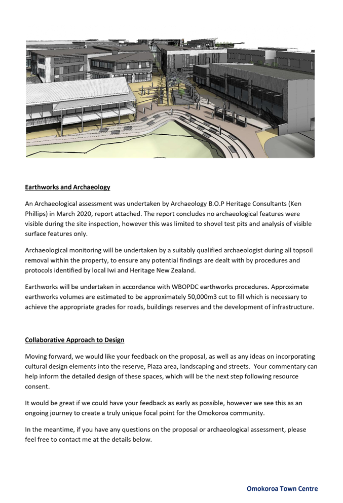
vi) Functional and alternative mixed use – the proposed design includes mixed use buildings including commercial and residential and also retail and office. A civic building is proposed adjacent to a plaza/market area with passive recreation and connection to the reserve/gully network which will create a focal point.
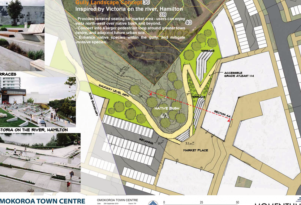
vii) Outlook to the adjoining gully system – the plaza/market area has been designed at the head of the gully to provide an active edge to the reserve and provide a focal point for the community. This area will provide connection to the walkway through the gully system.
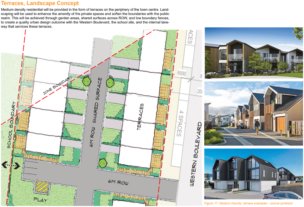
viii) Residential accommodation – the development proposes two residential areas within the town centre including medium density ‘terrace’ housing (buildings H1-H3 on Attachment 2 included at Attachment 1) on the south western boundary of the site, and apartment housing, above retail at ground floor, at the north eastern boundary of the site (building N on Attachment 2 included at Attachment 1). Accommodation is also provided by the proposed hotel/motel adjacent to the new round-a-bout. These activities assist to provide vibrancy within the town centre.
105. Further information was requested by Council on 18 June 2020 (refer Item 17 included at Attachment 3) to confirm how the proposed “Master Plan” will be implemented and provide Council, the community and future developers/businesses assurance as to the development outcomes.
106. It was confirmed by the applicant in the s92 RMA further information response (refer Item 17 included at Attachment 6) that the town centre master plan could be referenced in a condition of consent as “generally in accordance with”, that conditions of consent to reflect the urban design outcomes for detailed design at building consent stage could be included, and the general commercial zone permitted activity performance standards could be imposed as conditions of consent. The s92 response states that this approach will provide sufficient direction to ensure the development of the town centre has good urban design outcomes.
107. The Assessment of Environment Effects (AEE) states at section 3.2 (refer item 3 included at Attachment 1) that “no town centre plan has been prepared by Council” and Council requested by way of s92 request (refer Item 1 included within Attachment 3) details of the applicant’s community and stakeholder engagement in developing the “Master Plan”.
108. As part of the s92 RMA further information response (item 1 included at Attachment 3) the applicant confirmed that there was very limited consultation with Council (at a high level only) and no public consultation was undertaken while preparing the Master Plan or the application. The applicant held one public open day during the submission period and engaged with a number of commercial property owners in the area. Following public notification, the applicant amended the layout of building N and following discussion with Council‘s Strategic Property Manager, the Civic building and plaza/market area was increased in size.
109. While the District Plan does not define either in Chapter 19 or Chapter 3 (Definitions) what would be required as part of a Council prepared Masterplan, the applicant has undertaken limited Council and public engagement in preparing the town centre Master Plan. Limited consultation with the community makes it difficult to determine if the principles and strategy set out in the plan are in line with community aspirations and perspectives in order to achieve a shared vision for the future. It is also unclear how the Master Plan manages change in an area of rapid population growth, unique landscape and diverse community, along with the protection and enhancement of the areas intrinsic features and characteristics.
Referral – Resource Management
110. Council’s Resource Management department has reviewed the proposed development and make the following comments:
Master Plan:
111. The application provides no information as to how the Master Plan is to be implemented. There are basic guidelines, but how does the community, future developers and/or businesses ensure that the development occurs as presented in the Master Plan and discussed in the guidelines?
Following s92 response
112. There are some stronger references in the proposed conditions however we are still unclear how it will be implemented. There is a lot of reference to ‘detailed design’ however it is unclear when this will occur and how it fits into the process. This philosophy has the potential to rely on the engineering design process to resolve resource consent matters.
Urban Design Effects
113. To support the application and Master Plan, the applicant has provided an Urban Design Statement (UDS) prepared by Momentum Planning and Design (refer Appendix 4 included at Attachment 1) and have had this UDS independently peer reviewed (refer Appendix 5 included at Attachment 1). The UDS considers the urban design outcomes sought by the District Plan under Rule 19.5.
114. The applicants AEE gives consideration to the matters outlined in 19.5, and has been discussed in the Master Plan section above.
115. As part of the review of the application, Council requested that a peer review be undertaken. On behalf of Council, Mr Morné Hugo of Boffa Miskell has undertaken a peer review to determine the adequacy of the application in regards to the Master Plan and urban design effects of the proposed development.
116. In this peer review dated 29 January 2021 (included at Attachment 7) Mr Hugo concluded that:
· He is in general agreement with the urban design report and peer review document provided by the applicant
He believes that subject to an appropriate and well-developed detailed architectural, urban design and landscaping design scheme, the project will provide a vibrant, pleasant and environmentally appropriate outcome for the Ōmokoroa Peninsular.
117. Mr Hugo makes the following recommendations:
In order to ensure the above successful design outcomes are achieved the following items would need to be included as conditions of consent:
· Confirmation of all architectural designs, colours, materials and treatments for approval by Council prior to submission for building consent.
· Provision of final detailed landscape concept plans, a landscape management plan and maintenance programme compiled by a Registered NZILA Landscape Architect. These plans should incorporate all relevant boundary fencing, boundary landscaping and visual mitigation treatments proposed. The landscaping plans should also reference all external hard-surface paving treatments, soft landscaping components, shelters and canopy structures, water features and any other relevant landscape design components.
Character and Amenity / Landscape and Visual Effects
118. The subject site is located within the Ōmokoroa Stage 2 Structure Plan area, and has also recently been incorporated into the Stage 3 Structure Plan development. The Stage 2 Structure Plan provides for limited commercial development by way of a Master Plan to be prepared by Council.
119. The applicants AEE provides an assessment of bulk and scale of the proposed buildings which vary between one and three storeys high. The AEE states that due to the fall of the natural ground level and proposed earthworks some buildings will exceed the Commercial Zone performance standard in relation to height.
120. Under Rule 19.4.1(a)(iii)
“Ōmokoroa Commercial Zone Stage 2 Structure Plan Area: The maximum building/structure height in the Ōmokoroa Stage 2 Structure Plan area shall be 11m and no provision is made for additional non-habitable space above the 11m height limit”
121. The AEE states that the effects of building scale are acceptable and will provide legibility to the town centre, with the effects on the adjacent residential development being less than minor due to compliance with daylighting, yards and maximum height.
122. Section 4.4.4 of the AEE includes a specific assessment of building height encroachments and the reasons for the encroachments. Sheet 2.1.12A of the amended Architectural Plans (refer Attachment 1 included at Attachment 6) shows a rolling 11m height across the proposed modified ground level (final contours following earthworks). The modulated rooflines of Building M have encroachments along with more significant encroachments of over 3m including roof lines and balcony covers, and third floor dwellings of building N, shown in Figure 9 below.
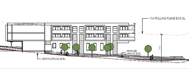
Figure 8: Showing Building N Height Encroachment
123. The original Master Plan prepared by the applicant provided a different layout for Building N, which placed the building and height encroachments on the northern boundary adjacent to the Kaimai Views subdivision. Following notification and submissions the applicant altered Building N to setback the bulk of the building from the northern boundary. While this has removed the bulk and scale at the adjoining boundary, it is noted there remains a large height infringement including third floor apartments and balconies, as shown in Figure 8 above. It is noted that daylighting requirements comply from the ‘residential’ boundary to Building N.
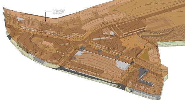 Figure 9: showing overheight in relation to ground
level
Figure 9: showing overheight in relation to ground
level
124. Further information was requested by Council in relation to the landscape and visual effects associated with the application (refer Item 22 included at Attachment 3) to enable Council to better assess such effects from the development, and in relation to Rule 19.7.2(b)(vi).
125. The further information response provided a Landscape and Visual Assessment prepared by Tom Watts of Momentum Planning and Design (refer Attachment 10 included at Attachment 6).
126. As part of the review of the application, Council requested that a peer review be undertaken. On behalf of Council, Ms Rebecca Ryder of Boffa Miskell has undertaken a peer review to determine the adequacy of the application in considering the actual and potential landscape and visual effects of the proposed development.
127. The initial peer review dated 21 December 2020 (included at Attachment 7) provided seven recommendations for the applicants LVA, and Ms Ryder has now meet with Mr Watts to discuss her recommendations. Following the meeting, Ms Ryder provided a supplementary letter and opinion dated 3 February 2021 (included at Attachment 7). Ms Ryder states that Mr Watts will provide a supplementary LVA which will cover off her recommendations.
128. Ms Ryders also states”
“It is my opinion the interface of architectural treatments and landscape treatments to the residential catchment is critical to the visual integration and mitigation of visual effects. These should include conditions of consent that manage the following
· Design controls of building heights, colour, reflectivity and materials for buildings H2m H3, A, N and O.
· Addressing the avoidance of building branding or signage on residential and future residential boundary interfaces
· Boundary landscape treatments including performance outcomes for vegetation treatment heights, typology and fencing treatments.
· Setting of building RL heights for specific buildings, as set out in the architectural plans. Avoidance of variance above these heights and the projected building height (from Ground Level), is important to ensuring the visual effects of building bulk, scale and effects on the visual catchment are maintained.
· Preparation of a landscape management plan that addresses Urban Design and Visual Effects mitigation treatments. It is noted that this should be submitted for the approval of Council as part of the Engineering Approval process. “
In my view the proposed development as a zoned commercial site, introduces potential low to moderate-low visual adverse effects upon the neighbouring residential visual catchment.
Therefore, the proposal is critical to limiting height intrusion, managing building treatments and soft landscape treatments at the boundary interfaces with residential and Ōmokoroa Road.
If certainty to the mitigation treatments and performance outcomes are clearly outlined, there is, in my opinion, potential to reduce the effect to a low visual effect and in turn be considered less than minor. I anticipate this can be achieved but providing further certainty through the pending response from Momentum Planning and Design and in turn conditions of consent.
129. Based on Ms Ryder’s review and recommendations I consider it appropriate for suitable conditions of consent to be imposed to limit building height, manage building treatments and soften landscape treatments.
Traffic and Access Effects
130. The site is accessed from Ōmokoroa Road which is classed as a Secondary Arterial in the District Plan and provides the only linkage between State Highway 2 and the peninsular, with the application site being located mid-block between the Prole Road and Settler Ave roundabouts (refer site location plan – Figure 1, page 6 of this report). The applicant intends to vest all roads in Council.
131. The application includes a Traffic Assessment (TA) prepared by Stantec (refer Appendix 7 included at Attachment 1).
132. The internal road network includes four roads to vest which have a road reserve of 20m and a carriageway width of 8m. It is noted that adjacent to Buildings O & N the road reserve narrows to allow connection to the 15m wide road reserve of Sentinal Avenue. The proposed roading layout and details including a typical cross section and are outlined in the application drawings (refer Attachment 17 included at Attachment 6).
133. The TA has assessed the road network and the expected traffic generation from the town centre development on the road network, and assessed the town centre design, its connections to existing and proposed roads and also pedestrian and cycle connectivity.
134. The Ōmokoroa Structure Plan Stage 2 identified the location and extent of the commercial area and the key connections onto Ōmokoroa Road. The key transportation elements of the Structure Plan Stage 2 include a new roundabout connection to Ōmokoroa Road (at Flounder Drive) and a northern connection, now via access through the Kaimai Views subdivision.
135. The Stage 2 Structure plan shows the intersection at Flounder Drive as a ‘Tee’ with no leg to the site. A future roundabout was budgeted and scheduled for construction in year 2032 and would have been a future upgrade from the current proposed ‘Tee’ intersection. Because of the Crown Infrastructure Partners (CIP) funding, Council has moved the construction of this roundabout forward, as part of the ‘shovel ready’ Ōmokoroa Road upgrade.
136. The internal road network consists of an extension to Sentinal Avenue which will continue from Kaimai Views through to Ōmokoroa Road. An internal roundabout is proposed to give access to a western road link to the rear of the site (not part of this application). The eastern roundabout link will provide access to convenience retail adjacent to Ōmokoroa Road.
137. The proposed Ōmokoroa Road/Flounder Drive roundabout is included in the application as a dual lane roundabout reflective of the expected size envisaged at the time of the original site zoning. However the TA results indicate that a single lane roundabout may be adequate and indeed more desirable to cater for the traffic at the intersection.
138. The Master Plan also proposes a left-turn in and out egress to and from Ōmokoroa Road at the northern end of the site. While this is not in accordance with the Stage 2 Structure Plan, it is proposed by the applicant to assist with delivery vehicles exiting from the supermarket service area, and to encourage access to Ōmokoroa Road, rather than egress through Kaimai Views.
139. The TA notes that traffic volumes within the Ōmokoroa peninsular have been rapidly increasing in recent years corresponding to development growth within the peninsular. The TIA provides a summary of existing traffic data:
“The current 7-day average daily traffic (ADT) volume on the SH2 to Prole Road section of Ōmokoroa Road is 7,066 veh/d, which compares with 4,946 veh/d in 2014, i.e. an increase of 43% in 5 years. For the section of Ōmokoroa Road between Goldstone Road and Kayelene Place, the 7-day ADT volume in 2019 is 5,803 veh/d which compares with 4,550 veh/d in 2014. This provides an increase of 28% in the last 5 years”
140. An assessment of the PM peak traffic generation has been undertaken by the TA by assessing the key activities as part of a large centre. Given the location of the site and mix of activities likely for a town centre (rather than a shopping mall) the TIA sets out a PM peak summary.
|
Retail/ Commercial/ Civic/ Childcare/ Office |
13,780m2 GFA at 7.7 trips per 100m2 |
1061 veh/h |
|
Office (first floor) |
6,155m2 GFA at 1.6 trips/ 100m2 |
98 veh/h |
|
Residential |
27 units @ 1.1 trip per unit |
30 veh/h |
|
Motel |
40 units @ 0.8 trips per unit |
32 veh/h |
|
Total trip generation (peak hour aggregate) |
1221 veh/h |
|
141. In terms of consistency with the Stage 2 Structure Plan the TA notes that the proposal is largely consistent with the current Ōmokoroa Stage 2 Structure Plan in terms of location and access provisions. The proposal to install a southern left turn in slip lane and northern left turn in/out, is a departure from the Stage 2 Structure Plan. The applicant proposes these additional connections to reduce the potential through traffic to Kaimai Views and to the Settler Avenue roundabout. The northern left turn out has been modelled and demonstrated that it can be readily accommodated on Ōmokoroa Road.
142. The TA concludes that the Master Plan roading network is expected to support the forecast levels of traffic generation by the development, with slower speed town centre roads supportive of pedestrian activity. Safe and efficient connections to the wider network can be achieved that are consistent with the classification of the roads.
143. Further information was requested by Council in relation to the transportation effects associated with the application (refer Items 38-66 included at Attachment 3) to enable Council to better assess such effects from the development.
144. The further information response provided information and response prepared by Stantec (refer Attachments 15a-15h included at Attachment 6)
145. In accordance with Rule 12.4.4.1(b) of the District Plan (Transportation and Property Access), where a subdivision or development includes the vesting of a new road it shall be designed to ensure safe and efficient movement of traffic (including heavy vehicles), while providing for pedestrian and cycleways, public transport, landscaping and tree planting. In accordance with Rule 12.4.4.1(a) Council will exercise controls over the function and design of new roading in relation to the needs of the subdivision, including requiring any upgrading of any existing roading necessary to serve the development. Any streetscape landscaping to be provided to enhance the amenity of the area shall be designed to ensure continued traffic and pedestrian safety in accordance with Rule 12.4.4.3 of the District Plan. Street lighting shall be provided in a manner to ensure safety of vehicles, cyclists and pedestrians in accordance with the Development Code and Rule 12.4.4.5 of the District Plan.
146. A Transport Assessment has been provided as part of the application details (refer Appendix 7 included at Attachment 1 and further information Attachment 15a-h included at Attachment 6).
147. The Transport Report provided by the applicant concludes that:
“The proposed Ōmokoroa Town Centre Master Plan has been assessed from a transportation perspective at a level appropriate to a Master Plan stage of development. The nature and form of the proposed development is largely consistent with the transport provisions of the Ōmokoroa Structure Plan included in the District Plan. In particular the principal access to the Town Centre is proposed by way of a roundabout located at the intersection of Flounder Drive and Ōmokoroa Road in accordance with the Ōmokoroa Structure Plan.”
148. As part of the review of the application, Council requested that a peer review be undertaken. On behalf of Council, Ms Ann Fosberry of Aurecon has undertaken a peer review to determine the adequacy of the application in considering the actual and potential transportation effects of the proposed development.
149. This peer review dated 5 February 2021 (included at Attachment 7) considers if the actual and potential effects have been assessed and mitigated to an acceptable limit.
150. Ms Fosberry’s key findings are:
· The roundabout was sensitive to the changes but would operate with an acceptable level of service into the future if it is a two-lane circulating roundabout
· That the proposed northern access does not operate at a satisfactory level of service for the right turn entering movement with the risk of the queue extending back into the through lane south, creating operational and safety issues and both right turn entering and exiting movements should be prevented;
· The Town Centre creates a destination and desire line for pedestrians and cyclists using the connection from Anglers Way which creates a safety risk for those who cross at this location
· From the sensitivity testing of the traffic modelling, in certain test scenarios queuing to exit from Road 4 onto Ōmokoroa Road may occur. If unduly delayed, northbound users will choose to divert through Sentinel Drive to Settlers Avenue to access Ōmokoroa Road. Similarly, because of the expected queuing and safety risk of right turn entering at the northern most JACE access, and the recommendation to only allow left in/left out, the reverse movement is likely to occur through Settlers Avenue and Sentinel Drive. To prevent “rat running”, road access between Sentinel Drive and the Town Centre development should be avoided and only pedestrian and cycle access provided for. Vesting the internal Town Centre road network in Council will provide Council with the opportunity to reassess the Sentinel Drive vehicle connection in the future, if necessary.
· The development proposal has an undersupply of parking as identified in Section 9.4 of the Stantec Transportation Assessment dated May 2020. A parking shortfall may result in overflow parking which may occur on Ōmokoroa Road or within areas that affect the safety of vulnerable road users within the town centre and the operation of the internal and external road network. Operational and safety concerns related to the identified parking shortfall remain
151. With regards to the Sentinal Avenue connection Ms Fosberry states
“The northern access right turn in, does not operate at an acceptable level of service under the sensitivity testing, with few gaps for the right turn entering traffic with it expected to queue back into the through lane, blocking southbound Ōmokoroa Road flows. Drivers will often divert to the next entry rather than queue and may travel further south to enter via the roundabout or try to divert via Settlers Avenue to access the JACE development via Sentinel Drive. Ōmokoroa Road is the strategic spine road (secondary arterial) and is a limited access road and as such additional intersections that disrupt flow are not acceptable. The road safety auditors have also recommended against right turn movements at this intersection. The northern most access is therefore recommended to be left in/left out only or left out only, as the central access between the roundabout and the northern access is a left in only and can accommodate the left turning traffic from Ōmokoroa Road without the need to provide another left turn in at the northern access”.
“To prevent drivers “rat running’ through the Kaimai Views development via Sentinel Drive and Settlers Avenue, the applicant has suggested that traffic calming be installed. Traffic calming at the interface between the JACE Town Centre proposal and Sentinel Drive is not considered an adequate control to prevent drivers choosing this route should queuing to exit onto Ōmokoroa Road at the northern access occur, as demonstrated in the sensitivity testing. Vehicle access between the JACE Town Centre and Sentinel Drive should be prevented and pedestrian and cycle access only, provided. With the road vested in Council, should a future need be identified to provide a vehicle connection, Council will have control of the road, to do this”.
Summary of Development Engineer and Westlink Referrals Comments
152. The Transportation Assessment provided by the applicant, and the further information provided in response to the section 92 RMA request from Council has been reviewed by Council’s Transportation team, Land Development Engineering team and Westlink (being the entity contracted to maintain Council’s roads) who advise the following:
153. The transportation matters have been reviewed by Mr Ken Lawton – Senior Land Development Engineer who comments as below
“A ‘northern’ access to Ōmokoroa Road was proposed by the applicant that provided for left turns in and out, as well as a right turn in. Council indicated to the applicant early on that the right turn in for this access would not be supported. I am comfortable that Council’s preferred arrangement for the ‘southern’ and ‘northern’ accesses provides for suitable access to and from the supermarket service area for commercial vehicles and a secondary entry/exit for private vehicles. However, although a northern right turn in may work, this would need further investigation and modelling to Councils satisfaction that this would not result in stacking back to the Settlers Ave roundabout.
In addition I still have serious traffic safety concerns with allowing traffic through the Kaimai Views residential subdivision to the town centre site via Sentinal Avenue”
154. With regard to the access through Kaimai Views from Sentinal Avenue Mr Lawton has serious safety concerns. He comments:
“The proposal is rather optimistic in regards to the proposed northern access to include for a right turn in off Ōmokoroa Road. There is reliance on this northern right turn in to assist in mitigating the effects of traffic through Kaimai Views (Sentinel Ave). Due to safety concerns on the planned Ōmokoroa Road upgrade, roundabout, stacking concerns raised in the Transportation peer review I am not supportive of this right turn in from Ōmokoroa Road.
Consequently, if there is no right turn in off Ōmokoroa Road, traffic is likely to utilise Kaimai Views and Sentinal Avenue as a through road to the town centre. There will be no mitigation of traffic and safety effects at Kaimai Views. No solution to traffic and safety effects is offered by the applicant, except some unspecified ‘traffic calming’ at the interface between the town centre and the residential area. Note that traffic calming is used to slow traffic NOT reduce traffic movements.
This is of serious concern to me given the nature of the Kaimai Views housing density, limited on site parking, narrow roading network and residents expectations for peaceful living.
I recommend no vehicular access between the town centre and Kaimai Views via Sentinal Avenue in order to mitigate the potential traffic and safety effects on Sentinal Avenue and Kaimai Views residents”
155. Mr Lawton also considers there to be outstanding matters in relation to:
· Timing with Councils Ōmokoroa Road upgrade and Councils Stage 3 Structure Plan review
· Proposed internal road reserve widths and their ability to accommodate all servicing, landscape plantings and heavy vehicle manoeuvring. The current widths proposed do not comply with the District Plan requirements. The applicant would need to provide detail to confirm the road widths are acceptable for all servicing, trees, parking etc., as it may impact the layout/ building design if the proposed road widths cannot accommodate all the requirements. Note this is not considered full engineering design and should be resolved prior to granting consent, if it is to be granted.
· Encroachment of buildings into Council‘s Ōmokoroa Road reserve designation area and final design/layout of Flounder Drive roundabout, as shown on Figure 10 below.
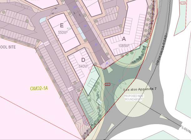
Figure 10: Diagram showing location of buildings within Council Designation
156. At present, I understand that Ms Fosberry and Mr Lawton have concerns with the proposal, with respect to the safety and efficiency of the roading network, including the strategic transport network. Council staff have considered these concerns and in light of the peer review Council will not support a right turn at the northern Ōmokoroa Road entrance. Council will also not support vehicle access from Sentinel Avenue to the town centre, in favour of pedestrian and cycle access only. In light of the concerns raised, I am of the opinion that adverse effects as they relate to transportation matters could be unacceptable. However, in my opinion the matters of concern raised above by Mr Lawton can be adequately conditioned to mitigate the effects to an acceptable level.
Carparking Effects
157. The application includes an indicative car parking layout as shown on the Master Plan. The Transportation Assessment also includes an assessment of parking demand based on the types of activities proposed as part of the Master Plan.
158. The TA has undertaken an assessment against the District Plan requirements for carparking with 898 car parks required based on the activities proposed within the town centre. The TA has also undertaken a parking demand assessment based on the range of activities and the demand through the course of the day across the site. This assessment identifies that 759 car parks are needed. The car parking provided is 92% of the assessed car parking demands (see section 9.4.2 of the TA). It is acknowledged that many of the activities will not have concurrent peak periods.
159. The Master Plan shows some 594 off-street car parks with 107 on-street car parks available. It is also acknowledged that further consideration will need to be given to the staged supply of parking to match the stage of the development, and that some activities will have their own car parking, such as the childcare, residential apartments and terraced housing.
160. Whilst the District Plan provisions will not be satisfied, as the wider site is expected to provide up to 701 spaces, it is considered peak parking demand will practically be met on site once shared use and time of day considerations are made such that overflow parking to surrounding areas is not likely to occur.
161. The TA concludes:
“The parking supply is of an appropriate order but recognising the possibility of actual demands varying form those forecast, it is recommended that a monitoring condition is imposed that requires the actual parking demands to be reviewed on completion of the development. In the event that monitoring shows there was an ongoing shortfall of car parks, additional car parks could be established by extending the at-grade car park next to the civic centre into the balance Future Urban land.”
162. Council’s Senior Land Development Engineers have considered the proposed carparking numbers and are overall satisfied that the shortfall is manageable within the balance area if necessary. As carparking will be rolled out in stages, suitable monitoring conditions similar to the above, but more specific to each stage, can be imposed to mange any carparking effects. The Concept Safety Audit also recommends a further review of the access to the supermarket carpark and this should be undertaken prior to draft conditions being prepared to ensure adequate access and carparking can be provided.
163. Under the National Policy Statement on Urban Design (NPS-UD) car parking policies have the effect of removing minimum car parking rates from the district plans of tier 1, 2 & 3 territorial local authorities (TLA). Western Bay of Plenty District Council is classed as a tier 1 TLA and will be removing the district plan rules around minimum car parking rates. WBOPDC will be undertaking this project as soon as practicable. While minimum rates can be removed, under the provisions detailed in the NPS-UD Council can still consider the effects of parking supply and demand in resource consents, and developers can determine the amount of parking necessary.
164. Overall Council agrees that the effects from car parking are acceptable subject to appropriate conditions. These conditions will include carparking requirements per stage and monitoring of carparking demands as the site is developed.
Infrastructure and Servicing Effects
165. A Resource Consent Servicing Report prepared by Lysaght Consultants was provided as part of the application details to confirm the suitability of the site development as set out in the application details (Appendix 6 included at Attachment 1).
Water
166. There is existing water infrastructure located within the Ōmokoroa Road reserve and within Sentinal Avenue. The development proposes to connect to both existing water mains. In accordance with the Servicing Report, a new 200mm water main is needed in the eastern side of Ōmokoroa Road, along with upgrading the 50mm rider main adjacent to Flounder Ave, to a 200mm main to complete the loop. The Servicing Report concludes that with the proposed water main upgrades there should be sufficient capacity to service the town centre for the predicted demand.
167. The applicant did not engage in pre-application discussion with Councils Utilities Team. The application did not include any modelling to confirm if there is sufficient capacity or if upgrades are required.
Wastewater
168. The Servicing Report provides a preliminary layout of the wastewater system that will be gravity fed to a pump station within the site. This will pump the wastewater via a rising main to the existing wastewater system on Ōmokoroa Road. The Servicing Report confirms from their calculations, there is adequate capacity in the network to receive the town centres wastewater.
Stormwater
169. The Servicing Report states that the downstream stormwater ponds will cater for all the land within the town centre site. Preliminary stormwater reticulation design has been prepared and included in the Servicing Report and discharges to the gully within the application site. The town centre road network will provide for a secondary flow path towards the gully system. The servicing report states the site can be easily serviced with stormwater infrastructure given the established downstream ponds and natural fall of the site.
Power & Telecommunications
170. The site has an existing power connection which will be required to be upgraded as the town centre is developed. Ultra-fast broadband is available in Ōmokoroa, and Chorus provided confirmation (refer Appendix 12 included at Attachment 1) that the network would be able to be extended to provide connection availability, subject to detailed design.
171. Further information was requested by Council in relation to the power and telecommunication servicing with the development (refer Items 83-85 included at Attachment 3) to enable Council to better assess such effects from the development, and in relation to Rule 12.3.8(n) and 12.4.8.
172. The further information response provided a letter from PowerCo (refer Attachment 19 included at Attachment 6). The response noted that with regards to Chorus, location of cabinetry will be addressed at time of detailed design, and are normally located within the road reserve.
173. Consultation with PowerCo shows that Ōmokoroa area has capacity constraints. PowerCo state:
“Load requirements greater than 1MVA will require reinforcement of the existing 11kV network, plus the installation of transformers and switchgear, and new LV reticulation for your development. There would be a customer contribution required for this work.”
174. During the submission period a submission was also received from PowerCo (refer Attachment 4), which reiterates that there are existing constraints on the local distribution network and some form of network reinforcement will be required to supply electricity to the development. It also notes that Powerco’s electrical networks are recognised as Regionally Significant Infrastructure in the Regional Policy Statement for the Bay of Plenty (RPS) and it is therefore appropriate that any developments avoid adverse effects on the electricity distribution network. The applicant has stated that discussions with PowerCo are ongoing but has not provided any further assessment of effects on the electricity distribution network.
Referrals Comment Summary
175. The Servicing Report provided by the applicant, and the further information provided in response to the section 92 RMA request from Council has been reviewed by Council’s Utilities team, Asset Management team and Land Development Engineering team who advise the following:
1) There is still some uncertainty in regard to the ownership (public or private) for water, wastewater and stormwater infrastructure. Not all services are covered by easements, where it is considered they are required. The applicant should check the Servicing Plan is correct and all easements are correctly shown. Confirmation should be provided if there is a mix of private and public service to ensure suitable conditions of consent can be prepared.
- The applicant has now confirmed the easement layout for services and a condition of consent can be imposed for easements over all services to vest.
2) Timing of vesting of stormwater reserve (Lot 102) and the purpose of the stormwater reserve is required to be confirmed, i.e. is it only a discharge point, or is there attenuation or treatment to be included. Further detail for stormwater within this lot should be provided by the applicant to ensure suitable conditions of consent can be formulated.
- The applicant has now confirmed that Lot 102 will only include a discharge point and all attenuation and treatment is via the downstream ponds
3) There is no mention of a pond or treatment area in the Services report. Consequently there is no reasoning why lot 102 is proposed to be vested at all and in particular as part of stage 1. However, there are benefits in vesting (management of discharge energies and water treatment) if Council is to own the upstream stormwater system. The applicant needs to confirm.
- The applicant has now stated the stormwater assets will ultimately form part of Council’s stormwater system for integrated maintenance reasons and consider it appropriate as there will be some catchment outside the town centre site that feeds into this network.
- Council staff are satisfied with this response and consider Lot 102 will provide good scope to continue development of the gully/walkway system.
4) The proposed wastewater pump station location may not be ideal, depending on the future development for the balance of the site. There has been no analysis if this location is the most ideal location for development within the site including the future balance lot development.
- Lysaght Consultants (authors of the Services Report) have now stated an analysis of the wastewater pump station was indeed undertaken, with consideration given to the entire site including future stages.
- Council staff have reviewed this response and note that while the pump station will cover the site, it will ultimately become a Council asset and it remains the preference of Council for the pump station to be located further north-west on the property to capture areas beyond the application site. This location has been indicated on the Stage 3 Structure Planning documents.
5) Underground spring management – this is a concern which has been raised with the applicant as there are existing underground springs which are located on the site. No analysis has been provided on how these springs will be managed as part of the development. This should be resolved prior to draft conditions being prepared to ensure they can be suitably managed within the development.
- The applicant has stated that the geotechnical engineers have not encountered springs on the property.
- Council staff consider this to leave uncertainty as the grated manholes which currently intercept the spring waters are clearly visible and a sketch map has been previously provided by Council to the applicant.
6) Complying locations of services in road reserves (including private) – for example, will service locations conflict with street tree requirements/locations? Larger or multiple cabling will require additional space in the services corridor and this has not been considered. Further detail should be provided by the applicant prior to granting consent to ensure road widths are sufficient for all services, noting that the current proposed road width is non-complying.
- The applicant has stated that service locations will be confirmed at the detailed design stage.
- Council staff still consider this an outstanding matter as it relates to the required 26m road width, as opposed to the 20m road width proposed. As the applicant is requesting dispensation for a narrower road width, Council need to be satisfied the narrow road width will not compromise the service locations, street trees or building layout.
7) There are questions around the future capacity in sections of Councils gravity wastewater pipelines in Ōmokoroa Road. However this capacity issue will not become a problem until full development of the future Stage 3 Structure Plan area is nearing completion. It is considered that the capacity issues will be resolved over time and the site if developed ahead of Stage 3 will not affect the current capacity.
8) The capacity of Councils water supply network has not been modelled by the applicant. There are assumptions in the Services Report that the network is designed for full development in the Stage 2 Structure Plan area. Within the s92 request the applicant proposes that Lysaght Consultants works with WBOPDC engineers to carry out the necessary modelling of the area, and to identify whether any off-site upgrades are required. This should be undertaken prior to granting consent to confirm capacity. If any upgrades are required, conditions of consent will need to be imposed.
- The applicant has now stated that as the site is zoned commercial, they assume that sufficient water supply will be planned for by Council.
- Council staff consider this an outstanding matter to be resolved prior to granting of a resource consent.
9) The feedback from Powerco appears to be somewhat ‘light weight’ and leaves the door open for PowerCo to demand upgrades later on. Council are not comfortable with this as it could result in changes to the site layout and servicing. Will a series of street level transformers be sufficient, or will a substation be needed? Powerco have recently indicated to Council as part of the Stage 3 Structure Planning, that a substation will be required. However, there are no sites identified for this under Stage 3 structure planning. It remains uncertain as to whether the site can be served in the interim with transformers.
- The applicant has stated that consultation is ongoing with PowerCo.
176. Mr Lawton also considers there to be outstanding matters in relation to:
- Modelling of water supply network and confirm capacity, this can then inform consent conditions
- Further detail and cross-sections confirming the suitability of the under width 20m road reserve to contain services, street trees, carparking and vehicle/commercial vehicle manoeuvring in accordance with Development Code requirements. The applicant has not satisfactorily demonstrated why Council should accept a non-complying road width.
- Underground spring management has not been satisfactorily resolved as Council will not accept subsoil drains under substantial building structures.
177. In giving consideration to the above referrals and the identified outstanding matters from Mr Lawton, I consider that all the matters can be adequately managed through suitable conditions to ensure the effects are acceptable. With specific regard to the road cross-sections and the proposed 20m width of the road, the applicant has provided cross-sections which show an indicative services layout including carparking and street trees. Suitable conditions can be imposed to ensure the cross-sections are achieved, without compromising the street trees, carparking and services layout
Earthworks and Geotechnical Effects
Geotechnical Matters
178. A Geotechnical Investigation Report (GIR) prepared by CMW Geosciences was provided as part of the application details to confirm the suitability of the site development as set out in the application details (Appendix 8 included at Attachment 1). The report identifies the geotechnical nature of the site, and recommendations for matters which will need to be mitigated through a detailed design process.
179. The GIR identifies a building line restriction which has been taken into account by the applicant when preparing the Master Plan. The GIR key findings are:
· The proposed town centre development is considered to be geotechnically acceptable
· The work will not worsen the instability of the site
· There is no increase in instability to other properties
· Is not at risk from issues of instability arising from both on-site and off-site (i.e. landslip originating from an adjoining property)
180. Further information was requested by Council in relation to the GIR, proposed earthworks and retaining walls (refer Items 32-37 included at Attachment 3) to enable Council to better assess such effects from the development, and in relation to Rule 12.4.1.
181. The AEE states at section 4.2.1 that localised retaining will be required around the site, which will be kept at a minimum and does not include any further details. However, the GIR notes that based on the architectural plans and site contours, earthworks will include cuts and fills supported by engineered designed retaining walls.
182. The further information response provided an update to the GIR (refer Attachment 14 included at Attachment 6). The response provided updated information in relation to the category of Geo-Professional who provided certification and a Cert 10b form.
Bulk Earthworks and Construction Matters
183. The application originally proposed to undertake large scale earthworks of approximately 50,000mᵌ, in order to allow for development of the town centre. While preliminary earthworks design has been undertaken the quantity is to be confirmed following the detailed architectural and engineering design, which will affect the finished contours. The application notes that earthworks are a non-complying activity. Preliminary earthworks drawings were provided within the architectural plans (refer sheets 2.1.03, 3.1.10 & 3.1.11 of Appendix 3 included at Attachment 1).
184. Further information in relation to earthworks was requested by Council in relation to earthworks (refer items 32-33 included at Attachment 3).
185. The further information response provided cut and fill plans and retaining wall location and cross-sections plans (refer Attachments 12 & 13 included at Attachment 6). The latest cut to fill plan shows that the fill will actually be 113,500m3 (solid measure). The cut and fill plan is not well supported by corresponding cross-sections. This volume of fill will expand to approximately 158,000m3 truck measure of imported material.
186. No further details under the s92 response were provided in terms of an assessment of effects of the bulk earthworks or construction works. The purpose of Rule 4A.5 of the Operative District Plan is to maintain natural character and amenity values by retaining existing landforms, natural features and significant vegetation; avoid creating new or exacerbating existing natural hazards; ensuring practical building sites and effective stormwater flow paths.
187. The application states that bulk earthworks and construction of the road/utilities network will be undertaken in fill as part of stage 1 of the development. The applicant has provided no further details or assessment of the period of the bulk earthworks and construction works will likely extend over (i.e. months/years) or the period for construction for the remaining stages as the development progresses in stages across the site. The applicant has not undertaken an assessment of effects in relation to potential amenity effects such as noise, traffic and access on adjacent properties and as such I cannot be satisfied as to the actual and potential amenity or traffic effects.
188. The application also did not include an indicative Construction Management Plan showing how effects on the adjoining neighbours could be minimised.
189. In order to determine the actual and potential effects of bulk earthworks and construction effects, the applicant is required to provide further information in relation to an assessment of actual and potential effects of bulk earthworks and construction activities.
190. This information was requested as part of the s92 request, but never adequately responded to.
191. The information required by Council includes but is not limited to:
· the total expected volumes of cut to fill and the volume of material to come from off site,
· the number of truck movements for filling,
· the time period for filling and bulk earthworks,
· hours of operation,
· the effects on amenity values of the surrounding area,
· vibration, noise, visual amenity,
· effects on the transportation network and other infrastructure,
· effects on safety of road users and vehicle accessways,
· indicative Construction Management Plan addressing the procedures to manage and control these off‐site effects. This includes a communication strategy with adjacent landowners.
192. It is also appropriate to include a construction noise condition based on the standard (NZS 6803:1999 ‘Acoustics – Construction Noise’) in the District Plan.
193. The applicant has provided supplementary information (included at Attachment 9) with regard to the proposed earthworks. They state that a further earthworks model has now been prepared which estimates 80,000m3 of imported fill is required for the site and states that the Ōmokoroa Road upgrade pavement design should take into account the likely projected construction traffic.
194. Council staff have reviewed this response and consider that it does not sufficient address the matters raised in the information requirements (section 186) above to assess the amenity effects from the earthworks as a non-complying activity. This remains an outstanding matter which needs to be further addressed by the applicant, however subject to appropriate conditions and taking into account the required Bay of Plenty Regional Council consents, on‐site construction activities can be adequately managed through strong conditions of consent to an acceptable level.
Referrals Comment Summary
195. In addition to the above, Mr Lawton also considers additional clarification is required:
· Location of the retaining wall including footings in relation to the southern boundary will create a ‘dead area’ area which is not easily accessible from the property for maintenance etc. What is proposed for this ‘dead area’ between the boundary and the retaining wall? i.e. planting to mitigate the visual effects (including graffiti). Who will maintain this area of land and can it be accessed from the site or will access be required over the adjacent property?
- the applicant has responded stating the neighbouring site, being the school grounds are likely to allow relatively straight forward access to the wall face. Also, that it may be possible to do away with the wall if the applicant batters out into the school property.
- Council staff have reviewed this response and note there has been no agreement provided from the Ministry of Education to enable access or a batter nor an indicative easement for access shown on the scheme plan.
· Confirmation of the area the retaining wall will require adjacent to the southern boundary and if this will impact on the proposed carparking and landscaping adjacent to this boundary. Further detail is required from the applicant.
- the applicant has stated that there is 3m between the top of the wall and the carpark which should be sufficient.
· There has been no engagement with the Ministry of Education as to the designated school site at the southern boundary and if the retaining wall and earthworks will impact their possible site layout or design.
- the applicant states that engagement with the Ministry of Education is ongoing.
Noise Effects
196. The proposed development incorporates residential, commercial, retail and entertainment activities, in addition to a childcare centre. The effects of future activities will be subject to individual compliance with the noise standards of the Commercial Zone. However the receiving environment to the north of the site is residential, which is different from the underlying commercial zone.
197. The AEE states that the noise effects of future activities will be subject to individual compliance with the noise standards of the Commercial Zone. It states that there are no special setback considerations required at the boundary between the commercial zone and adjoining residential development to the north due to the underlying commercial zone.
198. The proposal locates residential activities towards the northern and western boundaries of the development area which are expected to provide some separation between the adjacent sensitive residential sites and the true commercial activities.
199. The AEE states the town centre will comply with the District Plan noise standards and therefore the noise effects will be acceptable. No supporting information was provided with the application to confirm that the proposed activities and layout/design would comply with the District Plan noise standards.
200. Following the close of submissions and in order to better understand noise effects on adjacent residential dwellings both within the site and external to the site, further information was requested by Council in relation to noise effects, (refer Item 14, included at Attachment 3 and Item 7 included Attachment 5).
201. The further information response provided an additional assessment in relation to noise effects and an Assessment of Noise Effects prepared by Earcon Acoustics (refer Attachment 20 included at Attachment 6). The intent of the report is to assess noise effects from traffic associated with the proposed development, which includes:
· Predictive modelling of noise propagation from operational and traffic noise sources.
· Assessment of noise levels against relevant regulatory and standards-based criteria.
· Consideration of practicable mitigation measures for the control of noise.
Referral comments summary
202. The application was referred to Council’s Compliance and Monitoring Manager Ms Alison Curtis for comments in regards to noise effects (included at Attachment 7).
203. I rely on Ms Curtis assessment of the actual and potential noise effects in relation to the development including a review of the Acoustic Report provided as part of the s92 response.
204. Ms Curtis states that the site is proposed to be mixed use with section 19.5 of the Operative District Plan providing for the development of a Ōmokoroa Commercial area Master Plan which includes the proposal for mixed use zones. Specific amenity considerations and development of rules to apply requirements for mixed use zones have not been undertaken by Council and defined by the District Plan as Council has not yet prepared the Master Plan.
205. Ms Curtis notes that Council does not have mixed use zones catered for in the District Plan (which would provide for mixed residential and commercial activities in one area), and the application of the very limited residential accommodation noise levels within the existing commercial and industrial zones is not appropriate. Ms Curtis states that the upper floor residential was included to provide “caretaker” type residences within the commercial zone directly associated with an activity, i.e. owner/occupier business. Specific mixed-use large scale residential development has not been assessed as part of the District Plan.
206. Noise considerations in a mixed-use zone look at the wider implications of the specific residential receiver properties and the effects of high density living. Ms Curtis considers the residential environment for those properties within the commercial area needs to address noise from activities external and internal to the building. Those matters that will require consideration include:
· Internal building noise transmission for residential separate titles vs single ownership,
· Internal building noise transmission for mixed residential and commercial use,
· External noise sources and providing internal noise levels that provide a high degree of residential amenity,
· Ventilation requirements for fresh air versus air conditioning and how these will be assessed- building code, building consent assessment, resource consent assessment and acoustic certification following construction.
207. Ms Curtis recommends the following information be required from the applicant prior to the resource consent being issued:
· Earthworks and development –
Required: Specific commentary on the application of the construction noise standards in relation to the long term management of noise from the site should be made in the Acoustic report, e.g. construction noise management plan for truck movements, earthworks, foundation construction (sheetpiling etc).
· Residential accommodation –
Required: Detailed noise levels (predicted) at the building façade for all the residential buildings is required. Buildings N, and G are most likely to be affected by noise from outdoor sources day and night from the hospitality venues at buildings L, K, J and F, outdoor community spaces, childcare facility, and buildings machinery and plant.
Required: Detailed assessment of the construction details (STC ratings) for external façade attenuation.
· Noise source modelling
Required: modelling of all potential noise sources, and the receiving environment (levels to be specified per building and activity):
- Hospitality/café venues - in buildings L, K, J, and F are part of the proposal and need to be factored into the modelling. These could include bars/entertainment venues.
- Outdoor spaces - community spaces “plaza” adjoining building F, the glass roofed gazebo and the terraced area between buildings L and I.
- Traffic noise associated with servicing of the commercial spaces - truck deliveries etc
- Mechanical ventilation sources for all residential and commercial operations (assume building based plant e.g. rooftop or central ventilation systems, not individual units).
- Rubbish management for hospitality (glass breaking impact Lmax) on residential space
· Childcare Care
Required: assessment of the control measures, including building design, hard/vs soft outdoor surfaces, siting of outdoor activities through design, height/type of screening and draft noise management plan
208. In giving regard to the assessment above, and the recommendations from Ms Curtis, I am of the opinion that the noise effects can be adequately managed through appropriate conditions of consent to an acceptable level.
Economic Effects
209. The application includes an economic report prepared by RCG (refer Appendix 10 included at Attachment 1) which reviews the earlier economic reports that supported the original zoning including a revised report by Property Economics( that was commissioned by Foodstuffs in 2013), and a report prepared by RPS in 2018 prepared for the Ōmokoroa Stage 3 Structure Plan. The report also considers the practical issues with the Tralee Street commercial area and provides an assessment of the four Ōmokoroa Stage 3 Structure Plan options Council consulted on in 2018.
210. The report summary of key points finds that Ōmokoroa is still at an early stage of its development, although growing fast. Tralee Street is the other noteworthy retail area on the peninsular, however due to its size and location, will only ever serve part of the Ōmokoroa catchment. The earlier RPS Group reports recommend a 3.5ha town centre, excluding roads which is similar in size to the proposed town centre.
211. In terms of effects on other retail/commercial developments, sales in other centres can lead to a reduction in amenity and quality of the existing centres. This can be a significant economic effect. The report considers the Tralee St commercial centre to have the highest degree of competition. The RPS report states that the concern is less around the economic impacts that the town centre would have on other commercial areas, but more the economic impacts that Tralee Street commercial centre could have on the town centre.
212. The view of the RCG report is that the proposed site has similar locational characteristics as the town centre sites identified in the Stage 3 Structure Plan consultation options 1-3. The report notes that a supermarket is likely to be the main ‘anchor tenant’ which could be supported by a range of convenience, food and beverage and service activity initially.
213. The report notes that in the event that Fresh Choice (at Tralee Street) were to close, it is unclear if this would be a significant adverse effect. The report does not consider the social and economic impact of a closure on the other existing and consented commercial businesses. The report concludes that there is a negligible chance of significant adverse economic effects on Tralee Street and limited to ‘trade competition’ only.
214. As part of the Stage 3 Structure Plan process which Council has been undertaking, RPS Group have provided an update to their 2018 economic review (included at Attachment 8). The report considers three potential town centre locations being Site 1: a site between SH2 and the proposed Francis Road realignment, Site 2: the corner of Prole Road and Ōmokoroa Road and Site 3: this site (404 Ōmokoroa Road)
215. The RPS Report undertakes a comparison of the three possible town centre sites being investigated as options under the Stage 3 Structure Plan preparation. The comparison utilises a multi-criteria analysis with consistent assessment criteria as outlined at section 5.1 of the Report. The Report notes that the successful delivery of a Town Centre site should consider how other uses such as active reserves, local park, wider residential and employment (including industrial) can be located and delivered within the structure plan area.
216. Table 6 provides an evaluation of the three sites and conclusion:
Site 1: Not considered to be a workable outcome due to slope, roading uncertainty and lack of a proximate and sizeable residential catchment.
Site 2: The preferred site as it can deliver the best outcome for the community with the lowest risk profile.
Site 3: Likely to be a workable site, however, delivery and community benefits will be compromised by the built form response to the terrain. The outcome can be improved if retail and commercial uses occupy 4 hectares, and the balance of the currently zoned area is developed as residential.
217. The RPS Report concludes:
“Site 2 on the corner of Prole Road and Ōmokoroa Road is the preferred location for the Ōmokoroa Town Centre.
The flat site and proximity to a sizeable walkable residential catchment provide the best opportunity to deliver a range of retail, commercial and community uses that deliver the greatest overall benefit to the community.”
Referrals
218. Council’s Strategic Property Manager and Resource Management Manager have reviewed the application and both requested confirmation as to whether the proposed supermarket had been ‘truth tested’ with a supermarket operator to determine whether size, location, and servicing factors were suitable. This is due to the applications heavy reliance on a supermarket as an anchor tenant for the town centre.
219. The question was asked under the s92 request and the s92 response stated that discussion was being undertaken with a supermarket operator, however no further information was provided. Given the existing Fresh Choice in Ōmokoroa and submission received from their owner Woolworths NZ Ltd, and the Foodstuffs Group land owned close to SH2, there remains a question around the viability of the development if a suitable anchor tenant cannot be identified. This matter has not been addressed by the applicant.
Cultural Effects
220. There are no historic buildings or structures, significant trees or heritage features identified by the District Plan on this site.
221. The applicant had written to Pirirākau, Ngati Taka and Ngati Ranginui prior to lodging the application with Council. The application notes that consultation will be ongoing, and no formal comments, Cultural Impact Assessment or consultation response was received prior to lodging the application.
222. As part of Council’s resource consent referral process, the application was referred to Pirirākau, Ngati Taka and Ngati Ranginui. Pirirākau and Ngati Taka both responded stating they would be meeting with the application on site to discuss. No further referral comments were received.
223. During the submission period, Council received a neutral submission from Pirirākau Incorporated Society
“We seek ongoing engagement with Jace Investments Ltd to enshrine cultural mitigation within the project as outlined by a Memorandum of Understanding between Jace Investments Ltd and or Craig Lemon.”
224. I have contacted Ms Julie Shepard at Pirirākau to discuss the submission and if a Memorandum of Understanding has been reached between the parties. Ms Shepard has stated that engagement is ongoing with the applicant.
225. No adverse cultural effects are anticipated and a suitable condition of consent can be imposed in relation to engagement with hapū at the time of earthworks, and in relation to ongoing engagement and involvement is other cultural aspects such as tree planting, historical sign boards, road naming etc.
Archaeological Effects
226. An archaeological assessment prepared by Ken Phillips - Archaeology BOP (refer Appendix 11 included at Attachment 1) was provided as part of the application details. This report outlines there are no known archaeological sites within the site, however there are several recorded sites in the near vicinity and wider Ōmokoroa area representing elevated defended pa and undefended settlement and cultivation. There may be also undiscovered subsurface sites. Given the close proximity of recorded archaeological sites and frequent discovery of previously unrecorded archaeological sites during developments on the Ōmokoroa Peninsular, there is reasonable cause to suspect that unrecorded archaeological sites will be encountered during earthworks at the site.
227. The archaeological report recommends a program for the mitigation of effects on possible intact archaeological features during the site earthworks be established prior to commencing any ground disturbance. This will include an authority from Heritage New Zealand (HNZ) to damage or destroy unrecorded archaeological sites on the property during development.
228. The application was referred to Heritage New Zealand for comment, and HNZ advised it concurs with the archaeological assessment undertaken by Ken Phillips, and that an archaeological authority is required for the proposed works.
229. A suitable Advice Note related to archaeology would be included for any consent granted. The application details outline that an authority to modify will be applied for from Heritage New Zealand with respect to any unrecorded archaeology.
Reserve to vest, Public Realm and landscaping
230. One drainage reserve is proposed within the development, being Lot 102 located at the head of the gully at the northern boundary of the site.
231. Rule 12.3.2.1 of the Operative District Plan 2012 outlines that, as a controlled activity, in any zone, lots can be created for the purposes listed, including (b) ‘where land is to be set aside or vested as reserve’ and (c) ‘where land is to become public open space owned by Council’, without having to comply with the minimum lot sizes and other minimum standards for lots which would otherwise apply within the zone, provided the balance area of any subdivision complies with the relevant standards of 12.4 of the District Plan, namely the activity performance standards including 12.4.1 Site Suitability.
232. The application includes within the Urban Design Statement (UDS, refer Attachment 8 included at Attachment 6) details relating to public space and landscaping. The Statement recommends that a mix of hard and soft landscaping should be used throughout the development to enhance amenity and help break up carparking and hard surfaces. Planting will seek to integrate with native flora in the surrounding context, including the gully of trees in the north west of the site. The terraced area at the head of the gully reserve will have a strong pedestrian focus with paved walkways and may be used as a focal point for future Ōmokoroa market days.
233. The UDS states that a network of parks, reserves and green corridors is proposed throughout and around the edges of the town centre, encouraging biodiversity and amenity. However, on review of the Landscape Masterplan included within the UDS, it would appear the only reserve or green space area proposed is in the head of the gully. The only other green space within the development appears to be associated with dwelling gardens at Buildings H1-3 & G, street trees and screen planting along Ōmokoroa Road. There is also a small area of green space adjacent to Building N, however it is unclear if this would be considered public reserve.
234. The stormwater network and overland secondary flows are proposed to be discharged to the gully, via the Drainage Reserve (Lot 102). Section 4.7.3 of the AEE states that this discharge will require an outfall with energy dissipation devices such as rock armouring of the gully floor to prevent scour.
235. The application does not include any detail or discussion around how both stormwater discharge and amenity/planting of the gully will work together.
Referral
236. Council’s Reserves and Facilities team has reviewed the proposed development in relation to the proposed Local Purpose drainage reserves and make the following recommendations:
· Sec. 4.7.3 of the application states that the stormwater network will be completed during the detailed engineering design stage to follow. The Reserves and Facilities team anticipates that this will include associated design details for the gully (Drainage Reserve Lot 102) in accordance with point 1 and point 3 of this referral response.
- In the supplementary information provided (included at Attachment 9) the applicant states that the interface and walkways through the drainage reserve will require detailed design as will any stormwater reticulation through the drainage reserve and any specific outlet design.
· In the application the proposed Drainage Reserve will also contribute aesthetic and recreational benefits for the development and the Ōmokoroa community. Consequently, this referral response also anticipates an appropriate consent condition to reflect due presentation treatment of the Drainage Reserve to enable:
- The aesthetic and recreational opportunities that are inferred in the application;
- The aesthetic and recreational treatment of the Drainage Reserve is in sympathy with its drainage function;
- Practicable legal access by Council for ongoing maintenance and future development of the reserve as may be necessary.
Note – the applicant has agreed a condition of consent is appropriate.
· Many of the plant species indicated at section 7 of the “Ōmokoroa Town Centre Design Guidelines 30 Sept 2020” (refer Attachment 8 included at Attachment 1) are well suited to site; however, some species are not – indeed, a couple are contrary to the Development Code 2009 AP2&3.
· To avert future structural problems to street infrastructure and community problems with respect to excessive leaf litter, rat habitat, over-shadowing, loss of views in the neighbourhood, etc., we recommend that detailed plant species lists and planting design plans are required to be submitted for Council comment/alteration as may be required and approval prior to planting.
· With respect to a possible condition about availability of locally sourced native trees, it may be appropriate for such a condition to be more specific to ensure that any Council approved tree species which meet agreed standards and can be sourced through Pirirakau shall be obtained from that source.
· Until the applicant presents detailed landscape design and planting plans for approval, the Reserves and Facilities team has no further requirements or conditions at this stage.
237. The applicant has reviewed the other matters above and agrees that detailed planting plans can be prepared as a condition of consent (comments included at Attachment 9).
Civic Space
238. The application proposes a civic building near the head of the gully which will be a focal point of the centre and link to the market/plaza area at the head of the gully. This assists the town centre in providing functional and alternative mixed use for the development.
239. The civic building has been designed to face the head of the gully and overlook the proposed market place area. This ensures an active edge to the reserve and creates a focal point. Undercroft parking is also proposed under the civic building which will also provide a covered area for the market place.
240. Council’s Strategic Property Manager has reviewed the proposed development, and in particular noted the following:
· The civic space is too small. It would likely need to be double (i.e. 1400m2).
· There is no consideration of CPTED principles
· There is little public green space for community activities e.g. markets, civic ceremony’s
241. As no pre-application consultation had been undertaken with Council staff, under the s92 request I requested further details and assessment of the proposed use of the civic building and plaza and suggested engagement with Council’s Strategic Property Manager as to the size and suitability of the proposed building, location and market place area (refer item 5 included within Attachment 3).
242. Following the s92 request and the close of submissions the applicant meet with Council staff including Council’s Strategic Property Manager Mr Blaise Williams to discuss the civic building and market space.
243. The outcome of discussions with staff was for a larger civic building including a hall which could be used for multi-purpose activities and public gatherings, Council office space, break out rooms and public reception space, with approximately 1900m2 gross floor area to be provided. It was also requested by Council staff that the market/plaza area be increased in size from approximately 800m2 to provide for larger gatherings of 400 people. Council’s Strategic Property Manager also confirmed that Council would require ownership of the civic building.
244. The s92 response showed a reconfigured and larger civic building of approximately 1900m2, the market place increased to 1400m2, and a reduction in the size of Building L was made to allow for the larger more open market place/plaza. This will be of a sufficient size for some cafes and restaurants to have permanent alfresco dining, enable street art, bicycle parking and flexible market space. The applicant has included other market place examples (refer Attachment 6 included at Attachment 6) against which the area would likely be modelled.
245. The s92 response was referred to Mr Williams for review and comments. Mr Williams confirmed that the applicant had engaged with him and the proposed civic area and building was now acceptable in terms of size, dimensions and layout.
Safety and Security (Crime Prevention through Environmental Design - CPTED)
246. Following the s92 request for further information on CPTED principals in relation to the proposed underground carparks (refer item 6 included at Attachment 3), the s92 response provided further analysis of the CPTED principles.
247. The response states that access to underground carparks will be determined by the operating hours of the buildings above. While carparks are open, surveillance within carparks will be informal, from respective users and staff and formal from CCTV cameras. Multiple access points including stairs/ramps up to the supermarket and vehicle access from the northern end of building B provides options when entering and exiting the supermarket underground carpark. Underground carpark areas will be lit to ensure visibility is optimal for a large underground car park area.
248. I consider the effects in relation to CPTED to be less than minor.
Financial contributions
249. Growth in the District needs to be supported by infrastructure provided at appropriate levels of service. Financial contributions from development are imposed to mitigate potential adverse effects on the environment. If consent is granted, a review condition will be imposed to ensure that the infrastructure costs may be fairly recovered at the time that the subdivision consent stages proceed to a Registered Title.
250. A special assessment of the financial contributions has been provided as part of the s92 response information.
251. Financial contributions are payable in relation to the additional demand from activities and services created and will be applied in accordance with Section 11 – Financial Contributions of the District Plan.
252. If consent is granted financial contributions would be payable.
Subdivision Performance Standards
253. As a subdivision and development in the Commercial Zone a comprehensive assessment of effects against the relevant Activity Performance Standards for subdivision and development is required, including:
Rule 12.4.1 – Site Suitability
Rule 12.4.2 – Contaminants in Soil
Rule 12.4.3 – Extension of Services
Rule 12.4.4 – Transportation and Property Access
Rule 12.4.5 – Stormwater
Rule 12.4.6 – Wastewater Drainage
Rule 12.4.7 – Water Supply
Rule 12.4.8 – Network Utilities.
254. The application details provide an assessment against the District Plan provisions (refer AEE section 3.2 included at Attachment 1), and a geotechnical report prepared by CMW (refer Appendix 8 included at Attachment 1) outlines further the suitability of the site for development.
Referral Comments – Development Engineering
255. Council’s Senior Land Development Engineer Mr Ken Lawton has reviewed the application and advises that following review of the application detail and the s92 further information response Council supports the development in principle from an infrastructure requirements perspective. However, there are unresolved infrastructure issues that need to be resolved in order to provide Council certainty in formulating robust engineering consent conditions. The applicant seeks to rely on detailed design being provided at the Engineering Design Approval stage to confirm a number of matters.
256. Mr Lawton states “Overall there is a lack of detail provided in the application for earthworks, transportation, servicing and the ‘built’ environment. Compliance with Councils standards has not been adequately demonstrated. The application report tends to rely on resolving these through the engineering design process which Council officers consider inappropriate. This philosophy is carried through to the section 92 responses. It is considered that if these matters can be satisfactorily resolved, suitable conditions can be formulated to support the application”.
257. I have considered Mr Lawton’s outstanding matters and consider it appropriate to impose conditions of consent to manage these matters at the engineering design stage.
Positive Effects
258. Almost all the submissions in support of the application were in relation to the economic benefits of the proposed development for Ōmokoroa and wider District.
259. Positive effects do not pertain to the specific assessment criteria, however these are still considered relevant with respect to how the proposal aligns with the aspirations of the Ōmokoroa community. While the application has not specifically identified any positive effects on the environment associated with the proposed town centre how I consider the following to be positive effects:
· Employment opportunities and growth
· Economic benefit to Ōmokoroa Peninsular with dedicated town centre
· Reduction in SH2 traffic to other regional commercial/retail areas
· Live, work, play opportunities for positive social benefits
SUMMARY OF EFFECTS
260. In considering the above assessment on the actual and potential effects I consider the proposal will or is likely to have adverse effects on the environment that are considered less than minor, minor and more than minor. Those effects which are considered to be more than minor are transportation effects and earthworks effects as outlined above. However I considered that these effects can potentially be mitigated to an acceptable level subject to appropriate conditions of consent should consent be granted.
261. On balance I consider the actual and potential effects of the proposal to be minor and the proposal therefore passes the first test of s104D(1)(a) of the RMA.
OBJECTIVES AND POLICIES OF THE OPERATIVE DISTRICT PLAN
262. As a non-complying activity, regard must be had to the relevant objectives and policies in the Operative District Plan.
Commercial Zone
263. The relevant objectives and policies within Section 19 (Commercial Zone) are as follows:
19.2.1 Objectives
1. Consolidated commercial centres that are vibrant commercial environments that encourage social and cultural interaction.
2. Well designed commercial centres which reflect accepted urban design principles.
3. Convenient and safe commercial centres.
4. Commercial development of a scale that is appropriate for the location.
5. Public, civic and private space that relate well to each other.
6. Commercial centres that have a high level of amenity.
7. Commercial Zones in which commercial activities can operate effectively and efficiently, without undue restraint from non-commercial uses which may require higher amenity values.
8. Important heritage buildings and landscape features are retained.
9. An efficient network of road, cycle and pedestrian linkages connecting the District’s commercial centres to surrounding urban areas.
10. The development of commercial centres and associated transportation networks that enhance social, economic and cultural activity through attention to design detail and the integration of the public, civic and private places nearby and therein.
11. The development of town centres that complement adopted documents compiled with the respective communities such as town centre plans and comprehensive development plans.
264. In having regard to the objectives above I consider the proposal to be mostly consistent with the objectives 1-11 for the following reasons:
· The Master Plan shows a consolidated commercial area with mixed use residential incorporated to ensure a vibrant commercial environment.
· The architectural plans show a high level of design can be achieved throughout the development to reflect accepted urban design principles.
· The applicant has indicated the development can comply with CPTED requirements to provide a safe commercial centre.
· The Urban Design Statement and architectural plans show the development is at a scale appropriate to the location, especially with the inclusion of residential sensitive activities adjacent to the neighbouring Kaimai Views subdivision.
· The proposed market/plaza and civic space can be seen to interact well together with the surrounding buildings and reserve area providing a high degree of amenity for a public focal point.
· Landscape features can be retained and enhanced through the development of the gully head and public market space to achieve connection to the Ōmokoroa walkways and other reserve space.
Transportation, Access, Parking and Loading
265. The relevant objectives and policies within Section 4B (Transportation, Access parking and Loading) are as follows:
Section 4B - Transportation, Access, Parking and Loading
4B.2.1 - Objectives
1. To provide an integrated, efficient, safe and sustainable transportation network that supports the social and economic wellbeing, and land use pattern of the sub-region as defined in this District Plan and that maintains or enhances the regional strategic linkages.
2. To provide for more efficient land use, development and subdivision of existing areas in a way that recognises and integrates with the functions of different road types, transport modes and the defined transportation network.
3. To encourage the use and development of alternative modes of transport including, but not limited to, public transport, cycling, walking and other non-vehicular forms of transport that provide for an integrated, efficient, safe and sustainable transport network.
266. The applicant has stated that transportation outcomes reflect these objectives and provide for a low speed multi use environment. Council acknowledges and recognises that the internal road network, as a shared space, must be safe for all users. The applicant states carparking for both visitors and staff will be provided for within the town centre, with on street car parking and specimen tree planting helping to slow the traffic speed of the high street. The location of carparks has been carefully placed throughout the town centre to avoid having a dominant large tar seal area. The southern car parking area provides for weekend use of the school fields being located immediately adjacent. It is considered that this will help the town centre to be vibrant throughout the week and weekend.
267. Key pedestrian cycle and vehicle connections make the town centre permeable, encouraging connections from adjacent sites and promoting sustainable forms of transport. The application states there has been consideration of the existing public transport routes and also future alternative routes once the town centre is established will provide for multi modal transport options.
4B.2.2 - Policies
2. To avoid, remedy or mitigate the adverse effects of land use, development and subdivision on the safety, efficiency, sustainability and capacity of the transportation network.
3. To manage the land use, development and subdivision of areas to achieve compatibility with the roads they front and the wider transportation network, with particular regard to the potential effects on that network, including, but not limited to, the safe and efficient provision of site access at the local level and intersections within the wider network and the effects of reverse sensitivity experienced between the operation and use of the transportation network and the establishment of adjacent land uses.
5. To recognise and provide for network wide effects of land use change on transport networks by assessing the effects of land use change across the networks affected.
6. To recognise and provide for the function of each road as described in the road hierarchy, and provide for the efficient use of that road type, by managing the intensity and form of land use, development and subdivision that impact on these roads.
7. To encourage the efficient use of land particularly in identified land use zones to reduce the potential impacts on the transportation network.
8. To ensure land use, development and subdivision planning provides for the implementation of multi-modal transport activities including public transport, walking and cycling facilities that address the identified need for new facilities/networks or enhance existing facilities/networks.
9. To maintain or enhance the sustainable and efficient use of arterial and collector roads through the use of transport optimisation methods and techniques (for example traffic demand management) that encourage adjacent land uses to provide access in keeping with the function of the road in the roading hierarchy and support alternative modes of transport.
10. The access, parking and loading effects of activities on the transportation network shall be avoided, remedied or mitigated with particular regard given to the level of service the road provides within the District’s roading hierarchy.
11. Activities should be established and operate in a manner which ensures safe and effective on-site and off-site vehicle parking, manoeuvring and access and pedestrian access.
12. Provide safe, usable and attractive networks and associated linkages for pedestrians, cyclists and motor vehicles.
268. These objectives and policies provide direction in regard to how the development integrates with the safe and efficient functioning of the transport network. While there may be some engineering design elements to work through should the proposal be granted, the overarching policies are considered to be met. The proposal will create roads to vest, public market/plaza space and links to public walkways in accordance with the Development Code as shown in the scheme plan.
Amenity
269. The relevant objectives and policies within Section 4C (Amenity) are as follows:
Section 4C - Amenity
4C.1.2.1 - Objective
- An environment free of unreasonable noise in accordance with the character and amenity of the zone within which the noise is generated and received.
4C.1.2.2 - Policies
1. Ensure activities do not generate noise levels inconsistent with the character and amenity of the zone in which the generated noise is received.
3. Have regard to any relevant New Zealand standards, guidelines, or codes of practice in the assessment of applications for resource consents.
4C.5.2.1 - Objective
- Avoidance or mitigation of the potential adverse visual effects of activities situated in prominent locations or adjacent to residential areas.
4C.5.2.2 - Policy
- Ensure appropriate landscaping and screening is established in conjunction with activities so as to minimise potential adverse visual impact.
270. The application does not have specific regard to these objectives and policies.
271. The District Plan prescribes maximum noise limits for the Commercial Zone. Noise is also likely from the earthworks and construction phase and is an outcome of a land development of this scale.
272. However with regard to objective 4C.1.2.1 – consideration needs to be given to the mixed use of the zone and the reasonable noise limits for high density residential living within the development. This could be in the form of stricter night time noise limits and hours of operation for potentially noisy activities to ensure that reasonable noise limits are achieved for the residential dwellings. This can be achieved by suitable conditions of consent following further analysis as discussed in the sections above.
273. Overall the application is consistent with the above Objectives and Policies related to noise.
Financial Contributions
274. The relevant objectives and policies within Section 11 (Financial Contributions) are as follows:
11.2.1 - Objectives
1. Protection of the natural and physical environment and the social, economic and cultural wellbeing of people and communities from the potential adverse effects of new or intensified development.
2. The provision of adequate funding for and efficient utilisation of the District’s infrastructure.
5. Timing of development commensurate with the ability to make appropriate provision for infrastructure.
11.2.2 Policies
1. Actual or potential adverse effects on the natural and physical environment which would otherwise be created by new or intensified development should be avoided, remedied or mitigated through the use of financial contributions and other appropriate measures.
2. The effects of new and intensified development on infrastructure in the District should be mitigated through expenditure of financial contributions.
3. The costs of infrastructure should be allocated in an equitable manner over both existing and new users so as to ensure that such costs are not borne unfairly by the wider community.
4. Calculations to assess infrastructure requirements should be based on the level of service needed to meet peak demand.
5. Calculations shall not seek to do more than recoup costs actually incurred in respect of expenditure to provide infrastructure to deal with the effects of growth including, where appropriate, the costs of financing such infrastructure over time.
6. Where appropriate, contributions should be levied differentially to reflect the particular circumstances applying to different parts of the District.
9. Where appropriate, financial contributions that would otherwise be payable should be reduced or waived in recognition of specific environmental protection or enhancement measures proposed to be undertaken.
10. Where appropriate, consideration will be given to the reduction or waiver of financial contributions for recreation and leisure that would otherwise be payable in recognition of a historic oversupply of recreation and leisure land.
11. Provide a mechanism whereby a financial contribution can be taken to address or offset localised effects outside any approved development programme, or in lieu of works that would otherwise be undertaken by a consent-holder.
12. The full costs of required infrastructure and services should be paid when subdivision and development requires such provision outside an approved development programme.
13. Developers who fund infrastructure ahead of time in an approved development programme should be refunded only at the time that development funds become available.
275. The proposed development will result in additional demand on Council’s water, wastewater, stormwater and transportation (roading) infrastructure. If granted consent, then appropriate financial contributions will be imposed by consent condition under s108 of the Act as prescribed through the relevant Annual Plan’s schedule of Fees and Charges, to mitigate any adverse effect. We note that the plan requires Recreation and Leisure and Ecological financial contributions only for dwellings in the Commercial Zone. Accordingly the application is consistent with the above Objectives and Policies.
Subdivision and Development
276. The relevant objectives and policies within Section 12 (Subdivision & Development) are as follows:
12.2.1 Objectives
1. Subdivision and development that provides for and reinforces the existing built form and local character of an area.
2. Subdivision and development is planned in an integrated manner and provided with the necessary infrastructure and services to ensure that the land is able to be used for its intended purpose.
3. Infrastructure and services are designed and constructed to minimum standards which will result in improved environmental outcomes without significant additional cost to the community.
4. Sufficient infrastructure capacity is provided to ensure the efficient and equitable provision of services to all land in the catchment.
5. Comprehensive assessment of development proposals to ensure that the full effect of the proposal is able to be determined.
6. Subdivision and development that minimises the effects from stormwater run-off.
7. Subdivision design and development that takes into account the principles of optimum energy efficiency and the benefits of renewable energy.
12.2.2 Policies
1. All urban subdivision is to have regard to subdivision guidelines contained in the Development Code, Built Environment Strategy and urban design protocols and guidelines which provide urban design outcomes.
2. The design of subdivision is in accordance with structure plans.
3. Require subdivision to be undertaken in accordance with any staging requirements to ensure the effective and efficient servicing of land within the catchment.
4. Require subdivision and development to provide infrastructure and services to meet the reasonably foreseeable needs of other land in the vicinity of the development.
5. Require subdivision and development to comply with the minimum standards in the Development Code for the provision of infrastructure and services, or to an alternative standard which is as effective and efficient in the long term and results in improved environmental outcomes.
6. Require all subdivision and development proposals submitted to Council to include a comprehensive assessment prepared in accordance with the information requirements of the Development Code.
7. Subdivision and development practices that take existing topography, drainage and soil conditions into consideration with the aim of minimising the effects of stormwater run-off.
8. Require the design and development of subdivision to reflect the principles of optimum energy efficiency and solar energy gain (in relation to the size and shape of each proposed lot, and the design and orientation of the subdivision as a whole) and generation of renewable energy such as solar water heating.
9. Adverse effects of traffic generation from subdivision and development on the transport network will be avoided, remedied or mitigated.
277. The applicant states that significant consideration to the surrounding environment has been applied during the determination of the proposed layout. The town centre has been comprehensively designed taking into consideration the site constraints and the immediate context, including surrounding subdivisions and uses and also the wider landscape context. The infrastructure for the town centre is either established or is within close proximity to the site and able to be efficiently and effectively extended. New infrastructure will integrate into the existing networks. Capacities have been considered by the applicant and Council’s Utilities team and proposed upgrades have been documented in the Services Report. The town centre will be developed in stages with appropriate infrastructure for each stage, with all main services to be installed in the stage 1 development.
278. While the development is not in strict accordance with the Stage 2 Structure Plan requirements, I consider the addition southern slip lane left in and norther left in/left out to be appropriate for the scale of the development. Council’s access arrangement preferences (no norther right turn in and no vehicle access from Sentinal Ave) will ensure that main traffic flows are not directed through the narrow residential streets of Kaimai Views. The southern slip lane left turn in will also ensure that heavy vehicle deliveries to the supermarket will be removed from the main town centre road and roundabout.
279. Overall, I consider the application is consistent with the above Objectives and Policies in relation to subdivision and development.
OBJECTIVES AND POLICIES SUMMARY
280. In considering the above relevant objectives and policies, I find on balance that the application will not be repugnant to the objectives and policies of the District Plan. This passes the second limb of the gateway test of section 104D(b).
ASSESSMENT OF RELEVANT PLANNING INSTRUMENTS
281. The applicants AEE has not had regard to or assessed the higher order provisions of the relevant statutory documents, I consider these documents to be:
- National Policy Statements
- National Environmental Standards
- Bay of Plenty Regional Policy Statement (RPS)
- Bay of Plenty Natural Resource Plans (NRP)
282. As an assessment has not been undertaken by the applicant, I have undertaken below an appropriate consideration of the relevant statutory documents listed above.
NATIONAL POLICY STATEMENTS AND STANDARDS
National Policy Statement – Urban Development (NPS‐UD)
283. The NPS‐UD recognises the need for urban environments to be able to develop and change to meet the needs of people and community’s and future generations. The proposal provides for residential development, infrastructure and public spaces that are designed to function as an integrated and cohesive urban development to meet the needs of an expanding urban area, on land intended and zoned for this purpose. Accordingly, I consider the proposal is aligned with the National Policy Statement.
284. The NPS‐UD placed new requirements on local authorities within a high‐growth urban area. Through monitoring and related projections it has been concluded by Council that there is insufficient capacity within WBOPDC urban areas to meet these requirements. Accordingly, the Ōmokoroa Stage 3 Structure Planning process and plan change is being undertaken.
National Environmental Standard for Assessing and Managing Contamination in Soil to Protect Human Health (NESCS)
285. The Resource Management (National Environmental Standard for Assessing and Managing Contaminants in Soil to Protect Human Health) Regulations 2011 ensures that land affected by contaminants in soil is appropriately assessed and made safe for human use.
286. The site has historically supported grazing land and more recently a kiwifruit orchard. Consequently, the site is considered a piece of land on which an activity described in the Hazardous Activities and Industries List (HAIL) has been undertaken. The National Environmental Standards for Assessing and Managing Contaminants in Soil to Protect Human Health Regulations 2011(NES:CS) will apply to the proposed activities of soil disturbance, subdivision and a change in land use.
287. This was confirmed by a Detailed Site Investigation (DSI) done and reported by Geohazard Environmental on behalf of the applicant (refer Appendix 9 included at Attachment 1). The DSI has established based on a variety of historical information, a site walkover and sampling that multiple HAILs are known or suspected to have been, or currently are, present at the site. The DSI recommended that a restricted discretionary resource consent should be applied for under the NES:CS due to subdivision and land use changes at the site.
288. The applicant has applied separately for a NES:CS consent as the original NES:CS consent was incomplete in May 2020. A separate NES:CS application was received 29 September 2020 for a restricted discretionary activity under regulation 10. As the s92 response was only received on the 29 January 2021, the NES:CS component of the development has not been bundled with the comprehensive subdivision and land use consents for the town centre development.
289. The NES:CS application will be considered separately to this report.
REGIONAL POLICY STATEMENTS AND PLANS
Bay of Plenty Regional Policy Statement
290. The Bay of Plenty Regional Policy Statement (RPS) was made operative on 1 October 2014. The RPS provides a framework for sustainably managing the region's natural and physical resources. It highlights regionally significant issues with land, air, fresh and coastal water, infrastructure and biodiversity, including issues of significance to Iwi. It sets out what needs to be achieved (objectives) and how it will be achieved (policies and methods). The Western Bay of Plenty Operative District Plan is required to reflect the provisions of the RPS.
291. A summary of the relevant objectives and policies in the RPS applicable to this application are set out below:
|
Section |
Objective |
Policy |
|
Iwi Resource Management |
15, 16, 21 |
IW 4B (Iwi/hapū management plans - are there any relevant?) IW 5B (adverse effects on matters of significance to Maori)
|
|
Urban and Rural Growth Management |
23, 24, 25 |
UG 3A (travel demand management) UG 6A (sequencing of urban growth) UG 8B (High quality urban design and live-work-play principles) UG 9B (co-ordinate urban development and infrastructure) UG 11B (Managing the effects of subdivision, use and development on infrastructure) UG 12B (Quality open spaces) UG 13B (integration of land use and transportation) UG 14B (urban limits) UG 20B (reverse sensitivity)
|
|
Water Quality |
29 |
WL 7B (Minimising effects of land and soil disturbance) |
|
Water Quantity |
30 |
WQ 1A (efficient water use) WQ 7B (reducing water demand) |
|
Natural Hazards |
31 |
NH 9B (land is > 5ha) – |
Iwi Resource Management
292. The relevant objectives and policies that relate to ensuring Te Tititi o Waitangi are taken into account in achieving the purpose of the act include recognition of te tino rangatiratanga and Kaitiakitanga.
293. A development should ensure iwi and hapū resource management plans are taken into account in resource management decisions. Further, Policy IW 5B requires that when considering proposals that may adversely affect any matter of significance to Māori recognise and provide for avoiding, remedying or mitigating adverse effects on:
a) The exercise of kaitiakitanga;
b) Mauri, particularly in relation to fresh, geothermal and coastal waters, land and air;
c) Mahinga kai and areas of natural resources used for customary purposes;
d) Places sites and areas with significant spiritual or cultural historic heritage value to Tangata Whenua; and
e) Existing and zoned marae or papakāinga land.
294. The application demonstrates that the proposal will not adversely effect matters of significance to Maori. The applicant has undertaken engagement with local hapū, has undertaken a comprehensive Archaeological Assessment and will continue to work with Pirirākau hapū on cultural and planting opportunities within the town centre.
Urban and Rural Growth Management
· The relevant policies I have considered under this section are below:
· UG 3A (travel demand management)
· UG 6A (sequencing of urban growth)
· UG 8B (High quality urban design and live-work-play principles)
· UG 9B (co-ordinate urban development and infrastructure)
· UG 11B (Managing the effects of subdivision, use and development on infrastructure)
· UG 12B (Quality open spaces)
· UG 13B (integration of land use and transportation)
· UG 14B (urban limits)
· UG 20B (reverse sensitivity)
295. I have read the relevant policies listed above and I am satisfied that the application is consistent with these policies. The development has provided a considered approach to development, taking into account regional and local travel patterns, managing the effects of subdivision, ensuring high quality urban design and providing public open space. UG 14B states that urban activities shall not be developed outside of the urban limits, Map 8 of Appendix E of the RPS shows the site to be located within the Urban Limit (start 2021) and as such the development is consistent with this policy.
Land and Soil Disturbance
296. WL 7B (Minimising effects of land and soil disturbance) is relevant due to the nature and volume of the proposed earthworks on the site. Little information has been provided in relation to the effects of earthworks in relation to District Council requirements, and the applicant has confirmed they have applied for a Regional Council consent to undertake earthworks.
Water Quantity
297. With regards to WQ 1A and WQ 7B, I consider the proposed development to be in accordance with these policies.
Natural Hazards
298. The applicant has not had regard to policy NH 9B (as the overall site is greater 5ha) and accordingly there is no assessment against Appendix L to assess natural hazard risk. The site is not subject to any current District Plan Natural Hazard overlays, and it is subject to non-statutory mapping of floodable area within the gully area. It is also noted the land area within the site for the proposed development is 5.3ha, with a 2.6ha balance area.
299. The applicant has not commented directly on this policy and the Bay of Plenty Regional Council who have reviewed this application have not requested that the assessment be undertaken.
Regional Natural Resources Plan
300. The relevant section of the RNRP relate to:
· Kaitiakitanga
· Integrated Management of Land and Water
· Land Management
· Natural Hazards
301. I consider the relevant regional plans are the Regional Natural Resources Plan (RNRP) on the basis that the proposal will require earthworks and stormwater discharge. The BOPRC submission states that the on-site systems are unsuitable for a development of this scale. High groundwater will preclude individual on-site systems or a community wastewater system on the larger property. BOPRC state that the applicant will need to design and develop a suitable reticulation system.
302. Overall, given the extent of the construction works, on-site effluent treatment will need to comply with the relevant rules of the RNRP, or apply for the appropriate consent. Accordingly, I consider that the proposal is not contrary to the relevant objectives and policies within those plans.
Other Relevant Matters
Plan change / Structure Plan versus Resource Consent
303. The applicant has chosen to submit an application for resource consent to develop the property rather than request Council prepare a Master Plan for the site or prepare a Plan Change for the Structure Plan area. Given the proposal is not a prohibited activity there is nothing precluding this approach.
Ōmokoroa Stage 3 Structure Plan
304. As outlined in section 26-43 above, in the last 3 years prior to this application being lodged, Council had begun and was working on the Ōmokoroa Stage 3 Structure Plan. The background and history is outlined in section 26-43 where it is clear in the level of detail and community engagement that Council has undertaken as part of working through this process to provide a desired and agreed outcome for the community.
305. The applicant has chosen to disregard this structure plan process which was underway and has not discussed in the AEE the impact of this application on the process Council had been undertaking.
Part II of the Resource Management Act 1991
306. Part II of the Act provides the Purpose and Principles of the Act, principally under Section 5, which provides the overarching framework under which resource management decisions are made. The purpose is defined as:
(1) The purpose of this Act is to promote the sustainable management of natural and physical resources.
(2) In this Act, sustainable management means managing the use, development, and protection of natural and physical resources in a way, or at a rate, which enables people and communities to provide for their social, economic, and cultural wellbeing and for their health and safety while:
- Sustaining the potential of natural and physical resources (excluding minerals) to meet the reasonably foreseeable needs of future generations; and
- Safeguarding the life-supporting capacity of air, water, soil, and ecosystems; and
- Avoiding, remedying, or mitigating any adverse effects of activities on the environment.
307. The proposal has regard to the purpose of the Act in that natural and physical resources are being managed in a sustainable manner.
308. The proposal does not detrimentally affect the potential of the natural and physical resources to meet the reasonable and foreseeable needs of future generations, nor the life supporting capacity of water, soil, air and ecosystems. It is acknowledged that there are effects which require mitigation. This report finds that suitable mitigation can be incorporated to avoid significant adverse effects.
309. The matters in Part II should prevail over other provisions of the Act or other planning documents in the event of their being a conflict between these. Part II includes sections 5 (Purpose of the Act) and sections 6, 7 and 8 which are principles that are intended to provide guidance as to the ways in which the purpose of the Act is to be achieved.
310. The application of section 5 involves a broad overall judgement of whether a proposal will promote the sustainable management of natural and physical resources. The Act’s “use, development and protection” are a general indication that all resources are to be managed in a sustainable way, or at a rate which enables people and communities to provided for their social, economic and cultural wellbeing, and for their health and safety, while sustaining the potential of natural and physical resources to meet the reasonably foreseeable needs of future generations, safeguarding the life supporting capacity of air, water, soil and ecosystems, and avoiding, remedying or mitigating any adverse effects of activities on the environment. The enabling and management functions found in section 5(2) should be considered of equal importance and taken as a whole.
311. As discussed, in sections 93 - 254 of this report, the actual and potential effects generated by the proposed development can be mitigated to an acceptable level. The town centre development will provide for the economic wellbeing of the Ōmokoroa community and wider rural catchment, and the social wellbeing of the community by improving the diversity and supply of housing options in Ōmokoroa and providing a live, work, play opportunity.
312. For these reasons the proposal will achieve the purpose of the Act.
Section 6 RMA – Matters of National Importance
313. Section 6 of the Act details ‘Matters of National Importance’ that Council shall have particular regard to, including the preservation and protection of outstanding natural features, the natural character of the coastal environment, and historic heritage. The activity would not have an adverse effect on any of the stated matters.
314. The matters of Section 6 have been addressed and recognised in the application.
315. The application site currently contains no natural features, landscapes or historic heritage that requires protection.
316. The relationship of Māori and their culture and traditions with their ancestral lands, water, sites, waahi tapu and other taonga has been recognised through the town centre proposal as one that has significant positive cultural benefits, with hapū welcoming the opportunity to provide cultural input and assist with planting.
Section 7 RMA– Other Matters
317. Section 7 of the Act outlines ‘Other Matters’ that Council shall have particular regard to. Those matters deemed relevant are as follows.
(a) Kaitiakitanga
(aa) the ethic of stewardship
(b) the efficient use and development of natural and physical resources:
(ba) the efficient of the end use of energy:
(c) the maintenance and enhancement of amenity values:
(d) intrinsic values of ecosystems:
(e) maintenance and enhancement of the quality of the environment:
(j) the benefits to be derived from the use and development of renewable energy.
318. The proposal represents an efficient use and development of natural and physical resources. Linkages to existing community walkways and cycleways are provided and the market/plaza space provides a focal meeting point for the development. I consider that any adverse effects can be mitigated by the proposed design and layout to minimise the potential adverse effects on surrounding properties.
319. The proposal is considered to be generally consistent with Section 7 of the Act.
Section 8 RMA – Treaty of Waitangi
320. Section 8 of the Act requires all persons exercising functions and powers under it, in relation to managing the use, development, and protection of natural and physical resources, shall take into account the principles of the Treaty of Waitangi (Te Tiriti o Waitangi). Regard has been had to the Treaty of Waitangi and it is determined that for this application there are no matters of relevance. Consultation by the applicant has been undertaken with relevant hapū and is ongoing. The use and development of the site will not be contrary to section 8 of the Act.
321. The purpose of the Resource Management Act 1991 requires management of resources and acknowledges the ability to provide for social and economic benefits. However, simultaneously the effects of the activity on the environment, including on natural and physical resources, are required to be avoided, remedied or mitigated.
322. Given the previous assessment, it is determined the application is consistent with Part II.
SECTION 106 RMA
323. Council may refuse to grant a subdivision consent, or may grant a subdivision consent subject to conditions, if there is a significant risk from natural hazards. An assessment of the risk from natural hazards requires a combined assessment of the likelihood of the natural hazards occurring; the material damage that would result from natural hazards to the land where the consent is sought, other land or structures; and any subsequent use of the land that would accelerate or worsen the damage predicted from a natural hazard.
324. The site is not identified within a District Plan Natural Hazard Area, however recent technical information released by Council in November 2020 identifies flooding (from extreme rainfall) and liquefaction on this property. Both studies take into account the effects of climate change. The flooding is based on a 1% AEP (1-in-100 year) event in the year 2130 and shows in a low-lying area running through the property. The liquefaction classification for the majority of the property is “liquefaction damage is unlikely”. This technical report was prepared in accordance with the MfE / MBIE “Planning and Engineering Guidance for Potentially Liquefaction Prone Land “ (2017) to a Level B (calibrated desktop) level of detail. This level of assessment included consideration of data collected from geotechnical investigations and groundwater monitoring undertaken within the study area boundary as defined in the technical report. “Liquefaction damage is unlikely” means a probability of more than 85 percent that liquefaction-induced ground damage will be none to minor in a 1 in 500-year earthquake shaking event. At this stage there isn’t enough information to distinguish between Very Low and Low. More detailed assessment would be required. Following more detailed assessment a classification of Medium or High is also a possible categorisation but based on the information available this is considered very unlikely.
325. The applicant has not undertaken a Natural Hazards Risk Assessment under the Natural Hazard provisions of the RPS, because the development area is less than 5ha I do not consider it necessary to undertake this assessment, and the Bay of Plenty Regional Council have not requested this assessment be undertaken.
326. Based on the above, it can be concluded that under Section 106 the site is appropriate for the proposed subdivision and development, subject to suitable conditions in line with the recommendations of the CMW Geotechnical Report and in relation to minimum floor levels if required.
CONCLUSION
327. After considering the actual and potential effects on the environment of allowing the application, it is my conclusion that adverse effects on the environment will be more than minor as they relate to transport. I consider that these effects have the potential to be mitigated and suitably controlled through conditions of consent, such that they are no more than minor and acceptable.
328. Overall I consider the proposal represents an activity that is envisaged by the District Plan and will not be repugnant to the relevant objectives and policies of the Operative District Plan and accordingly can satisfy both limbs of the s104D “gateway” test.
329. Having considered all of the relevant matters under Sections 104 and 104B it is my opinion that consent should be granted.
Attachments to Report
Please note that all attachments described within this report can be viewed on Council’s website using the following link:
|
8 March 2021 |
7.3 Summary of Submissions - JACE Investments Ltd - 404 Omokoroa Road, Omokoroa - Independent Commissioner Hearing
File Number: A3995370
Author: Barbara Clarke, Senior Governance Advisor
Authoriser: Jan Pedersen, Group Manager People And Customer Services
Executive Summary
This report provides the ‘Summary of Submissions’ (Attachment 1) received in relation to an application made by JACE Investments Ltd for Land Use and Subdivision Consent to establish a Mixed-Use Commercial Town Centre at 404 Omokoroa Road, Omokoroa. [RC11997L & RC2996S]
full copies of submissions
Please note that the full copies of all submissions to this application can be viewed on Council’s website using the following link:
1. Summary
of Submissions - Agenda Copy ⇩ ![]()
|
8 March 2021 |
7.4 Initial Section 92 Request for Further Information - JACE Investments Ltd - 404 Omokoroa Road, Omokoroa
File Number: A3995373
Author: Barbara Clarke, Senior Governance Advisor
Authoriser: Jan Pedersen, Group Manager People And Customer Services
Executive Summary
This report provides the Section 92 Request for Further Information dated 18 June 2020, (Attachment 1), and provides details of the information requested (Attachment 2), in relation to an application made by JACE Investments Ltd for Land Use and Subdivision Consent to establish a Mixed-Use Commercial Town Centre at 404 Omokoroa Road, Omokoroa. [RC11997L & RC2996S]
1. Section
92 Request for Further Information dated 18 June 2020 ⇩ ![]()
2. Section
92 Request for Further Information dated 18 June 2020 - Details of Information
Requested ⇩ ![]()
section 92 responses to requests
Please note that all Section 92 Responses to Requests can be viewed on Council’s website using the following link:
|
8 March 2021 |
7.5 Section 92 Request for Further Information Following Close of Submissions - JACE Investments Ltd - 404 Omokoroa Road, Omokoroa
File Number: A3995375
Author: Barbara Clarke, Senior Governance Advisor
Authoriser: Jan Pedersen, Group Manager People And Customer Services
Executive Summary
This report provides the Section 92 Request for Further Information following the close of submissions, dated 29 July 2020 (Attachment 1), and provides details of the further information requested (Attachment 2), in relation to an application made by JACE Investments Ltd for Land Use and Subdivision Consent to establish a Mixed-Use Commercial Town Centre at 404 Omokoroa Road, Omokoroa. [RC11997L & RC2996S]
1. Section
92 Request for Further Information Following Close of Submissions - dated 29
July 2020 ⇩ ![]()
2. Details
of S92 Request for Further Information following Close of Submissions - dated
29 July 2020 ⇩ ![]()
section 92 responses to requests
Please note that all Section 92 Responses to Requests can be viewed on Council’s website using the following link: